Green River (North Carolina)

Last updated
Green River
Tributary to Broad River
Green River, North Carolina.jpeg
Upper Green River during low flow below Lake Summit, North Carolina
USA North Carolina relief location map.jpg
Red pog.svg
Location of Green River mouth
Location
Country United States
State North Carolina
Counties Henderson
Polk
Rutherford
Physical characteristics
Sourcedivide between Green River and French Broad River
  locationabout 0.25 miles east of Green River Gap
  coordinates 35°09′47″N082°35′06″W / 35.16306°N 82.58500°W / 35.16306; -82.58500 [1]
  elevation2,720 ft (830 m)
Mouth Broad River
  location
about 0.5 miles upstream of Pores Ford Bridge
  coordinates
35°15′29″N081°58′10″W / 35.25806°N 81.96944°W / 35.25806; -81.96944 [1]
  elevation
720 ft (220 m)
Length58.2 mi (93.7 km) [2]
Basin size241.02 square miles (624.2 km2)
Discharge 
  location Broad River
  average520.59 cu ft/s (14.741 m3/s) at mouth with Broad River [3]
Basin features
Progressionnortheast then southeast
River system Broad River
Tributaries 
  leftLong Rock Branch
Uncles Creek
Falls Creek
Meetinghouse Creek
Rock Creek
Joe Creek
Vernon Creek
Freeman Creek
Laurel Creek
Beek Creek
Hill Branch
Mill Creek
Hungry River
Pulliam Creek
Gadd Creek
Laurel Branch
Brights Creek
Panther Creek
Rotten Creek
Britten Creek
Walnut Creek
  rightSouth Prong Green River
Shoal Branch
Bear Wallow Creek
Aaron Creek
Phillips Creek
Falling Creek
Terry Creek
Davis Creek
Jones Creek
Camp Creek
Cove Creek
Little Cove Creek
Silver Creek
Wheat Creek
White Oak Creek
WaterbodiesLake Summit
Lake Adger

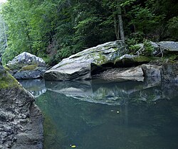
The Green River is a dam-release river that flows through the mountains of North Carolina, south of Asheville. [4] The Green has numerous tributaries, but much of its water flows from a confluence with Big Hungry Creek. The Green River is itself a tributary of the Broad River. The river is dammed to form Lake Summit, in Tuxedo, North Carolina, and Lake Adger near Mill Spring, NC. The Green River is named for its deep green color but runs brown after heavy rains.

Contents

Landscape

The Green River begins in the Blue Ridge Mountains of North Carolina and flows through the Blue Ridge Escarpment into the Piedmont. The river basin itself is not mainly sediment, but rather consists of metamorphic rock. The humid subtropical climate provides for moderate temperatures and relatively mild winters. The precipitation for the areas around the Green River typically ranges from 100 to 140 centimeters annually. [5]

Ecology

The area surrounding the river is all deciduous forest and is known for having some of the "highest floral and faunal biodiversity in the eastern United States." The Green River basin is typical of most southeastern mountain creeks as it is home to many animals, including deer and black bears. A few prominent deciduous trees in and around the Green River Basin are the Maple, Birch, and Oak Trees. The Green river serves as both a source of fresh water to a specific ecosystem, as well as a source of food to many consumers. [6]

Angling

The population of freshwater trout draws many anglers to the slower-moving lower Green. [6] The world record V-lip redhorse was taken from the Green River in 2018. [7] The world record notchlip redhorse was also taken from the Green in 2018, but by a different angler. [8] The current North Carolina State Muskellunge record of 41 Lbs 8 Oz was caught in Lake Adger in 2001

Whitewater Sports

The Green River is well known for its different types of whitewater sports including whitewater kayaking, canoeing, and tubing. Because the flow of water is controlled by dam-release, the river has sufficient water to support whitewater sports approximately 300 days a year. This makes the Green River available for whitewater enthusiasts to use even when other popular rivers such as the Chattooga River and the Nantahala River do not have enough water flow to support whitewater kayaking or canoeing. The three main sections of the Green River are: The upper Green, The "Narrows" section, and the lower Green. While all of these stretches of water are very closely connected they each have unique terrain and characteristics, and each section tends to draw different types of boating.

Upper Green

This section of the Green River is frequently run by kayakers, as well as persons paddling whitewater canoes, and other types of solo boaters. It is approximately 3.7 miles in length and has an average gradient of 49 feet per mile. This top section of the Green River begins below the Tuxedo Hydro Station, which controls the water flow, and ends at the beginning of the "Narrows" section. Because it is directly above the "Narrows" section, the Upper Green is often used by whitewater paddlers to access the Narrows. With only two significant rapids (Class III), it is considered a moderately difficult section by most whitewater paddlers. This section of the Green is narrow and resembles what would be considered a creek, rather than an actual river. The hydrology and nature of the water on this particular section of water makes it a popular spot for playboating, a style of whitewater kayaking. [9]

The Narrows

The "Narrows" section of the Green river has many qualities of a steep creek that drops between pools, and doesn't resemble many broad, slow-moving rivers in the southeast. John Pilson describes the Narrows as "boulder congested" with a "pool-drop character." This length of the river is considered an extremely difficult portion of whitewater, as it contains nine class IV rapids, and eight class V rapids (these being the most difficult runnable rapids). The first official descent of the Narrows was made in 1988, and it is still frequently paddled today. However, the Narrows are typically only paddled by seasoned whitewater boaters with an extensive knowledge of boating technique. Many whitewater enthusiasts have been injured here, and three qualified Class V boaters have died on the Green River. Three of the biggest and most notorious class V rapids on this section are known as the "Big Three." These are "Go Left and Die" (Class 5.1), "Gorilla" (Class 5.2), and "Sunshine" (Class 5.2). [10] An incident on "Sunshine" rapid left one whitewater kayaker paralyzed. [11]

This technical section of water is home to the Green River Race that is held every year on the first Saturday of November. The race typically involves many different classes of boats, and contains a section judged by time trial, as well as a head-to-head section of the race. Many paddlers consider the Green River Narrows race to be the pinnacle of whitewater racing in the southeast.

Part of the reason that the Narrows are so notable is because they have a downward gradient of over 100 feet per mile. The entire section of river is about 3 miles in length.

Lower Green

This run is frequented by both kayakers and tubers. Many local companies promote tubing as a type of "safe" whitewater tourism on the Green. The entire run is considered a class II section of water, appropriate for introductory level whitewater enthusiasts. This section of the Green River is very mild compared to its counterparts and is approximately six miles in length.

Bridges

Peter Guice Memorial Bridge (I-26)

See also

Related Research Articles

<span class="mw-page-title-main">Whitewater</span> Turbulent and aerated water

Whitewater forms in a rapid context, in particular, when a river's gradient changes enough to generate so much turbulence that air is trapped within the water. This forms an unstable current that froths, making the water appear opaque and white.

<span class="mw-page-title-main">Whitewater kayaking</span> Type of water sport

Whitewater kayaking is an adventure sport where a river is navigated in a decked kayak. Whitewater kayaking includes several styles. River running; where the paddler follows a river and paddles rapids as they travel. Creeking usually involving smaller, steeper, and more technical waterways. Creek boats tend to be short but high volume to allow for manoeuvrability while maintaining buoyancy. Slalom requires paddlers to navigate through "gates". Slalom is the only whitewater event to be in the Olympics. Play boating involves staying on one feature of the river and is more artistic than the others. Squirt boating uses low-volume boats to perform special moves in whitewater features.

<span class="mw-page-title-main">San Miguel River (Colorado)</span> River

The San Miguel River is a tributary of the Dolores River, approximately 81 miles (130 km) long, in southwestern Colorado in the United States. It rises in the San Juan Mountains southeast of Telluride and flows northwest, along the southern slope of the Uncompahgre Plateau, past the towns of Placerville and Nucla and joins the Dolores in western Montrose County approximately 15 miles (24 km) east of the state line with Utah.

<span class="mw-page-title-main">Watauga River</span> River in the United States of America

The Watauga River is a large stream of western North Carolina and East Tennessee. It is 78.5 miles (126.3 km) long with its headwaters in Linville Gap to the South Fork Holston River at Boone Lake.

<span class="mw-page-title-main">Hiwassee River</span> River in the United States of America

The Hiwassee River originates from a spring on the north slope of Rocky Mountain in Towns County in the northern area of the State of Georgia. It flows northward into North Carolina before turning westward into Tennessee, flowing into the Tennessee River a few miles west of what is now State Route 58 in Meigs County, Tennessee. The river is about 147 miles (237 km) long.

<span class="mw-page-title-main">Cheat River</span> River in West Virginia, United States

The Cheat River is a 78.3-mile-long (126.0 km) tributary of the Monongahela River in eastern West Virginia and southwestern Pennsylvania in the United States. Via the Ohio River, the Cheat and Monongahela are part of the Mississippi River watershed. Owing to the ruggedness of the surrounding Allegheny Mountains, the Cheat remains largely remote with few settlements or developments along its banks. Its headwaters are in the Cheat-Potomac Ranger District of the Monongahela National Forest.

<span class="mw-page-title-main">Deerfield River</span> River in Vermont and Massachusetts, United States

Deerfield River is a river that runs for 76 miles (122 km) from southern Vermont through northwestern Massachusetts to the Connecticut River. The Deerfield River was historically influential in the settlement of western Franklin County, Massachusetts, and its namesake town. It is the Connecticut River's second-longest tributary in Massachusetts, 2.1 miles (3.4 km) shorter than Metropolitan Springfield's Westfield River.

<span class="mw-page-title-main">Chattooga River</span> River in the Southeastern USA

The Chattooga River is the main tributary of the Tugaloo River.

<span class="mw-page-title-main">Nantahala River</span> Stream in North Carolina, USA

The Nantahala River is a river in western North Carolina in the United States, within the Nantahala National Forest, and near the Great Smoky Mountains National Park. Two-lane U.S. Highway 19/74 runs along the river, picnic areas dotting the route. In 1839, this was an unimproved large path, part of what became known as the Trail of Tears as the Cherokee people were forcibly removed from their homelands in this region to west of the Mississippi River and Indian Territory.

<span class="mw-page-title-main">International scale of river difficulty</span> Scale of skill needed to navigate a section of river

The international scale of river difficulty is an American system used to rate the difficulty of navigating a stretch of river, or a single rapid. The scale was created by the American Whitewater Association to evaluate rivers throughout the world, hence international in the title. It should not be confused with the internationally used whitewater scale, which is published and adapted by a committee of the International Canoe Federation (ICF). The grade reflects the technical difficulty and skill level required associated with the section of river. The scale is of use to various water sports and activities, such as rafting, riverboarding, whitewater canoeing, stand up paddle surfing, and whitewater kayaking.

<span class="mw-page-title-main">Narrows of the Green</span>

The Narrows of the Green is a 2.9-mile (4.7 km) section of the Green River in Henderson County and Polk County, between the Big Hungry Creek confluence and the Fishtop access area, in western North Carolina, United States. It is roughly 35 miles (56 km) south of downtown Asheville.

<span class="mw-page-title-main">Kettle River (St. Croix River tributary)</span> River in Minnesota, United States

The Kettle is an 83.6-mile-long (134.5 km) tributary of the St. Croix River in eastern Minnesota in the United States. Via the St. Croix River, it is part of the watershed of the Mississippi River. The river's English name is due to the large number of large rounded holes (kettles) in the sandstone in and around the river, carved out by the swirling waters of the river. The river's Dakota name Céġa watpa entered into English via the Anishinaabe people's Akiko-ziibi, both meaning "Kettle River".

<span class="mw-page-title-main">Creeking</span> Canoeing and kayaking involving the descent of waterfalls and slides

Creeking is a branch of canoeing and kayaking that involves descending very steep low-volume whitewater. It is usually performed in specialized canoes and kayaks specifically designed to withstand the extreme whitewater environment in which the activity occurs. In addition, the canoes and kayaks give the paddler improved performance and maneuverability needed to avoid river obstacles.

<span class="mw-page-title-main">Bee Cliff (Tennessee)</span>

The Bee Cliff is a prominent northeast Tennessee geological limestone feature with high caves that overlooks the Watauga River and the Siam community of Carter County, Tennessee.

<span class="mw-page-title-main">Whitewater canoeing</span> Paddling a canoe on a moving body of water

Whitewater canoeing is the sport of paddling a canoe on a moving body of water, typically a whitewater river. Whitewater canoeing can range from simple, carefree gently moving water, to demanding, dangerous whitewater. River rapids are graded like ski runs according to the difficulty, danger or severity of the rapid. Whitewater grades range from I or 1 to VI or 6. Grade/Class I can be described as slightly moving water with ripples. Grade/Class VI can be described as severe or almost unrunnable whitewater, such as Niagara Falls.

<span class="mw-page-title-main">Boonton Gorge</span>

The Boonton Gorge is a river gorge in Boonton, New Jersey where the Rockaway River drops over several waterfalls, and travels for slightly over a mile before emptying into the Jersey City Reservoir.

<span class="mw-page-title-main">Outline of canoeing and kayaking</span> Overview of and topical guide to canoeing and kayaking

Canoeing – recreational boating activity or paddle sport in which you kneel or sit facing forward in an open or closed-decked canoe, and propel yourself with a single-bladed paddle, under your own power.

<span class="mw-page-title-main">Extreme racing</span>

Extreme racing involves paddling a kayak down a section of hard whitewater. The race is similar to a timed version of creeking. The rivers used for this sport are typically class V, containing waterfalls and dangerous rapids. Races may have mass-starts or individual timed runs. Having two boat categories is also becoming popular among extreme racers. Many races have different classes including short boat, long boat, and hand paddle.

<span class="mw-page-title-main">Nantahala, North Carolina</span> Township in Macon County, North Carolina

Nantahala Township is located in North Carolina, United States in the part of Macon County which is west of Wayah Gap. It has a population of 1,711. "Nantahala" is a Cherokee word which means "The sun between them".

References

  1. 1 2 "GNIS Detail - Green River". geonames.usgs.gov. US Geological Survey. Retrieved 27 July 2019.
  2. "ArcGIS Web Application". epa.maps.arcgis.com. US EPA. Retrieved 27 July 2019.
  3. "Green River Watershed Report". Waters Geoviewer. US EPA. Retrieved 27 July 2019.
  4. Burmeister, Walter F. (1976). The Southeastern Rivers: Rivers of Virginia, North Carolina, South Carolina, Georgia and Florida. Oakton, VA: Appalachian.
  5. Benke, Arthur C. (2005). Rivers of North America. California: Elsevier Academic Press.
  6. 1 2 Shelford, Victor E. (1963). The Ecology of North America . Urbana: University of Illinois Press.
  7. "Redhorse, v-lip". igfa.org. International Game Fish Association. Retrieved 17 May 2019.
  8. igfa.org. International Game Fish Association https://igfa.org/igfa-world-records-search/?search_type=CommonName&search_term_1=Redhorse,%20notchlip . Retrieved 17 May 2019.{{cite web}}: Missing or empty |title= (help)
  9. Bell, Chris. "Green, North Carolina, US". American Whitewater. Retrieved 13 March 2012.
  10. Pilson, John. "American Whitewater - 2. Green Narrows, Green North Carolina, US". American Whitewater. Retrieved 21 February 2012.
  11. Hairr, John (2007). North Carolina Rivers: Facts, Legends, and Lore. Charleston, SC.{{cite book}}: CS1 maint: location missing publisher (link)