Related Research Articles
Cumberland is an incorporated village municipality east of Perseverance Creek, near the east coast of central Vancouver Island, British Columbia. The Comox Valley community is west of BC Highway 19 and is by road about 105 kilometres (65 mi) northwest of Nanaimo and 10 kilometres (6 mi) southwest of Courtenay.

Morden Colliery Historic Provincial Park is a 4-hectare (9.9-acre) historic provincial park near the east coast of southern Vancouver Island, British Columbia. The location off BC Highway 19 is about 102 kilometres (63 mi) by road northwest of Victoria, and 10 kilometres (6 mi) south of Nanaimo.
The Kent Coalfield was a coalfield in the eastern part of the English county of Kent. The Coalfields Trust defines the Kent Coalfield as the wards of Barham Downs and Marshside in the Canterbury district, and the wards of Aylesham, Eastry, Eythorne & Shepherdswell, Middle Deal & Sholden, Mill Hill and North Deal in the Dover district.

Nordegg is a hamlet in west-central Alberta, Canada within Clearwater County. It is located in the North Saskatchewan River valley in the foothills of the Canadian Rockies, just east of the intersection of the David Thompson Highway and the Highway 734 spur of the Bighorn Highway. A former coal mining town, it was named after Martin Nordegg and the name probably means "North Corner" in a German dialect. The railway station name at the locality was called Brazeau rather than Nordegg at certain points in its history, but the local post office has always been named Nordegg. The name Brazeau is now obsolete.
Coalmont was a tiny mining town, 11 miles (18 km) northwest of Princeton, British Columbia, Canada, on the north bank of the Tulameen River. The population of Coalmont is roughly 100 full-time residents. It is near the community of Tulameen and Otter Lake and the Coldwater Junction of the Coquihalla Highway. The town was established in 1912 to serve as a supply point to the neighbouring coal mine at Blakeburn.
Rhondda Heritage Park, Trehafod, Rhondda, South Wales is a tourist attraction which offers an insight into the life of the coal mining community that existed in the area until the 1980s.

Chatterley Whitfield Colliery is a disused coal mine on the outskirts of Chell, Staffordshire in Stoke on Trent, England. It was the largest mine working the North Staffordshire Coalfield and was the first colliery in the UK to produce one million tons of saleable coal in a year.
Cynheidre Colliery was a coal mine located in the Gwendraeth valley, in Carmarthenshire, South Wales. Opened in 1954, it closed in 1989.
Victoria Mines is a community in the Canadian province of Nova Scotia, located in the Cape Breton Regional Municipality on Cape Breton Island.

Chisnall Hall Colliery was a coal mine in Coppull in Lancashire, England. It was the largest coal mine on the Lancashire Coalfield north of Wigan. The colliery on Coppull Moor was owned by Pearson and Knowles Coal and Iron Company in 1896 when it employed 135 underground and 48 surface workers. The colliery appeared on maps in 1908 as a coal mine with two shafts and railway sidings connecting its 1.5-mile mineral railway to the London and North Western Railway's West Coast Main Line. In 1930, Pearson & Knowles merged with the Wigan Coal and Iron Company and others and their collieries became the property of the Wigan Coal Corporation. More than 1,000 people were employed there in 1933 and more than 300,000 tonnes of coal were produced annually.

Lille is a ghost town and former village in the Crowsnest Pass area of southwest Alberta, Canada. It was a company-built coal mining community that, between 1901 and 1912, hosted a population that grew to over 400. The mines at Lille closed in 1912, due primarily to weak coal prices, increasing production costs, and the increasingly poor quality of the coal. The community was then dismantled and most of its structures were moved elsewhere. Today the site is an Alberta Provincial Historic Resource and is known for the elegant ruins of a set of Bernard-style coke ovens that was imported from Belgium.
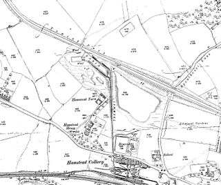
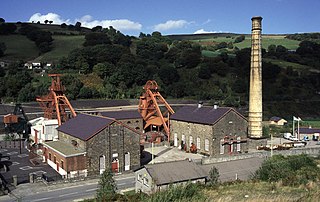
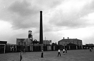
Hamstead Colliery in Hamstead, England, produced coal between 1878 and 1965, by mining the South Staffordshire 'Thick' coal seam. It suffered a major fire in 1908 in which 26 men died.

Bickershaw Colliery was a coal mine, located at Pennington, in Leigh, then within the historic county boundaries of Lancashire, England.
Parsonage Colliery was a coal mine operating on the Lancashire Coalfield in Leigh, then in the historic county of Lancashire, England. The colliery, close to the centre of Leigh and the Bolton and Leigh Railway was sunk between 1913 and 1920 by the Wigan Coal and Iron Company and the first coal was wound to the surface in 1921. For many years its shafts to the Arley mine were the deepest in the country. The pit was close to the town centre and large pillars of coal were left under the parish church and the town's large cotton mills.

Bradford Colliery was a coal mine in Bradford, Manchester, England. Although part of the Manchester Coalfield, the seams of the Bradford Coalfield correspond more closely to those of the Oldham Coalfield. The Bradford Coalfield is crossed by a number of fault lines, principally the Bradford Fault, which was reactivated by mining activity in the mid-1960s.
The Tarenni Colliery and its associated workings, are a series of coal mines and pits located between the villages of Godre'r Graig and Cilybebyll located in the valley of the River Tawe, in Neath Port Talbot county borough, South Wales.
The Kathleen Mine was a coal mine that operated in the nearby coal town of Dowell, Illinois, United States, from 1918 to 1946. At peak production, its output was 5,000 tons/day of coal. It was operated by the Union Colliery Company in St. Louis. Many miners who worked in the Kathleen were immigrants from eastern Europe, including Rusyns

The Burnley Coalfield is the most northerly portion of the Lancashire Coalfield. Surrounding Burnley, Nelson, Blackburn and Accrington, it is separated from the larger southern part by an area of Millstone Grit that forms the Rossendale anticline. Occupying a syncline, it stretches from Blackburn past Colne to the Yorkshire border where its eastern flank is the Pennine anticline.
The Prince of Wales Colliery, was a coal mine that operated for over 130 years in Pontefract, West Yorkshire, England. It was permanently closed in 2002 after geological problems were found to make accessing remaining coal reserves unprofitable, and most of the site was later converted for housing.
Passburg is a ghost town in the Municipality of Crowsnest Pass in southern Alberta, Canada that was formerly a coal mining community. It is on Highway 3 approximately 130 km (81 mi) west of Lethbridge and 4 km (2.5 mi) southeast of Bellevue.
References
- ↑ "Crowsnest Highway" . Retrieved 2013-03-27.
Coordinates: 49°36′52″N114°26′37″W / 49.614432°N 114.443550°W