Related Research Articles

East Northamptonshire was a local government district in Northamptonshire, England, from 1974 to 2021. Its council was based in Thrapston and Rushden. Other towns included Oundle, Raunds, Irthlingborough and Higham Ferrers. The town of Rushden was by far the largest settlement in the district. The population of the district at the 2011 Census was 86,765.
The history of the English county of Rutland, located in the East Midlands. It was reconstituted as a district of Leicestershire in 1974 by the Local Government Act 1972. This district was given unitary authority status on 1 April 1997.
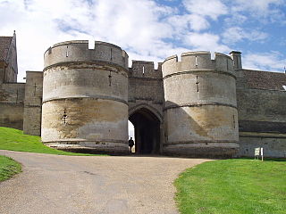
Rockingham Castle is a former royal castle and hunting lodge in Rockingham Forest, approximately two miles north from the town centre of Corby, Northamptonshire.

Kettering is a constituency in Northamptonshire represented in the House of Commons of the UK Parliament since 2005 by Philip Hollobone, a Conservative.

Great Easton is a village and civil parish in the Harborough district of Leicestershire, England. The parish had a population of 558 according to the 2001 census, increasing to 671 at the 2011 census.
The rural district of Hallaton existed in Leicestershire, England from 1894 to 1935. It included the following civil parishes, which were the parts of the Uppingham Rural Sanitary District in Leicestershire.
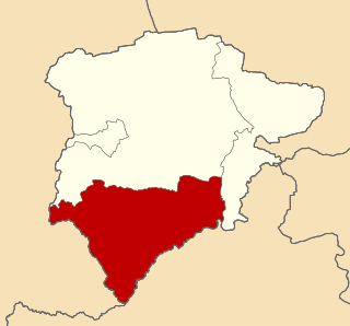
Uppingham was a rural district in Rutland, England from 1894 to 1974, covering the south of the county.
Thrapston was a rural district in England from 1894 to 1935. It was one of the only rural districts to be split between administrative counties, with part in Northamptonshire and part in Huntingdonshire.
Oundle and Thrapston was a rural district in Northamptonshire, England from 1935 to 1974.
Kettering was a rural district in Northamptonshire in England from 1894 to 1974.
Oxendon was a rural district in Northamptonshire, England from 1894 to 1935.
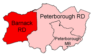
Barnack was a rural district in the Soke of Peterborough and later Huntingdon and Peterborough from 1894 to 1974.
Uffington was a rural district in Lincolnshire, Parts of Kesteven from 1894 to 1931.
Northampton was a rural district in Northamptonshire, England from 1894 to 1974.

Medbourne is a village and civil parish in the Harborough district, in the county of Leicestershire, England. The population of the civil parish at the 2011 census was 473.

Stamford Baron St Martin was a civil parish in Stamford, England, including the southern part of Stamford, south of the River Welland, and therefore historically part of Northamptonshire. It remains an ecclesiastical parish used by the Church of England; the parish church is St Martin's.

North Northamptonshire is one of two local government districts in Northamptonshire, England. It is a unitary authority area forming about one half of the ceremonial county of Northamptonshire. It was created in 2021. Its council is based in Corby, the district's largest town. Other notable towns are Kettering, Wellingborough, Rushden, Raunds, Desborough, Rothwell, Irthlingborough, Thrapston and Oundle.

Gretton railway station was a railway station near Gretton, Northamptonshire. It was on the Nottingham direct line of the Midland Railway of the Midland Railway. The steps up to the former platforms can still be seen, but the station building itself is in private ownership.

Rutland, archaically Rutlandshire, is a ceremonial county in the East Midlands of England. It borders Leicestershire to the north and west, Lincolnshire to the north-east, and Northamptonshire to the south-west. Oakham is the largest town.

Corby was a non-metropolitan district with borough status in the county of Northamptonshire, England. It bordered the East Northamptonshire district to the east, the Borough of Kettering to the south and west, the Harborough district of Leicestershire to the north-west, and the county of Rutland to the north-east. In 2021 the district had a population of 75,571. The council, Corby Borough Council was based at the Cube in the town of Corby.