
Blaby is a local government district in Leicestershire, England. The district is named after the village of Blaby, although the council is based in Narborough. The district covers an area lying south-west of the city of Leicester. Several of the district's settlements form part of the wider Leicester Urban Area, including Glenfield, where Leicestershire County Council has its headquarters at County Hall, and the town of Braunstone.
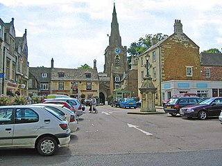
Uppingham is a market town and civil parish in the ceremonial county of Rutland, England, off the A47 between Leicester and Peterborough, 6 miles (10 km) south of Oakham. It had a population of 4,745 according to the 2011 census, estimated at 4,853 in 2019.

The Parts of Kesteven are a traditional division of Lincolnshire, England. This division had long had a separate county administration, along with the two other Parts of Lincolnshire, Lindsey and Holland.
The history of the English county of Rutland, located in the East Midlands. It was reconstituted as a district of Leicestershire in 1974 by the Local Government Act 1972. This district was given unitary authority status on 1 April 1997.

Buckingham Rural District was a rural district in the administrative county of Buckinghamshire, England from 1894 to 1974, covering an area in the north-west of the county. It was named after but did not include the borough of Buckingham.
Winslow Rural District was a rural district in the administrative county of Buckinghamshire, England from 1894 to 1974, covering an area in the north of the county.
The rural district of Castle Donington in Leicestershire, England, was formed in 1894 and abolished in 1974. It was formed by the Local Government Act 1894 from the part of the Shadlow Rural Sanitary District that was in Leicestershire.
The rural district of Hallaton existed in Leicestershire, England from 1894 to 1935. It included the following civil parishes, which were the parts of the Uppingham Rural Sanitary District in Leicestershire.
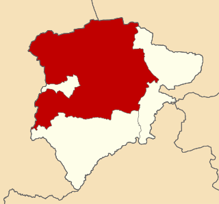
Oakham was a rural district in Rutland, England from 1894 to 1974, covering the north of the county.
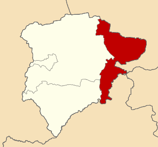
Ketton was a rural district in Rutland, England from 1894 to 1974, covering the east of the county. The district was named after Ketton.
Ampthill was a rural district in Bedfordshire, England from 1894 to 1974. It entirely surrounded but did not include the urban district of Ampthill.
Bedford Rural District was a rural district in Bedfordshire, England from 1894 to 1974. It surrounded but did not include the Municipal Borough of Bedford and Kempston Urban District.
Biggleswade was a rural district in Bedfordshire, England from 1894 to 1974. As initially created the district entirely surrounded but did not include Biggleswade, which was an urban district in its own right. In 1927 the parish of Sandy, which bordered Biggleswade, also became an urban district, leaving an island of two urban districts surrounded by the rural district.
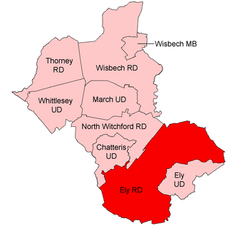
Ely Rural District was a rural district in England from 1894 to 1974. It was named after Ely, but did not include the city itself, instead covering the rural area to the west and north of it. It formed part of the administrative county of the Isle of Ely from 1894 to 1965, when this was merged into Cambridgeshire and Isle of Ely.

Thedwastre was a rural district in West Suffolk, England from 1894 to 1974. Thedwastre was formed under the Local Government Act 1894, from the part of the Stow Rural Sanitary District which was in West Suffolk. It was named after the historic hundred of Thedwastre.

Rutland County Council is the local authority for the non-metropolitan county of Rutland in the East Midlands of England. Since 1997 the council has been a unitary authority, legally being a district council which also performs the functions of a county council.
Oakham was an Urban District in Rutland, England from 1911 to 1974. It was created under the Local Government Act 1894.

Rutland, sometimes archaically called Rutlandshire, is a ceremonial county in the East Midlands of England. It borders Leicestershire to the north and west, Lincolnshire to the north-east, and Northamptonshire to the south-west. Oakham is the largest town.

St Neots was a rural district in Huntingdonshire, England from 1894 to 1974, around the northern and eastern sides of the urban area of St Neots.

