
Donhead St Mary is a village and civil parish in southwest Wiltshire, England, on the county border with Dorset. The village lies about 2+1⁄2 miles (4.0 km) east of the Dorset town of Shaftesbury and stands on high ground above the River Nadder, which rises in the parish.

Denton is a village and civil parish in the South Kesteven district of Lincolnshire, England. The population of the civil parish was 273 at the 2011 census. It is situated approximately 3 miles (5 km) both south-west from the market town of Grantham, and west from the A1 road.

Tixover is a small village and civil parish in Rutland. The population of the civil parish at the 2001 census was 174, falling to 163 at the 2011 census.
North Luffenham is a village in Rutland, in the East Midlands of England. The population of the civil parish at the 2001 census was 704, decreasing to 679 at the 2011 census. It lies to the north of the River Chater, 5 miles (8.0 km) east of Uppingham and 7 miles (11 km) west of Stamford. Located to the north of the village is St George's Barracks, formerly RAF North Luffenham.

Caldecott is a village in the county of Rutland in the East Midlands of England. The civil parish population was 256 at the 2001 census increasing to 269 at the 2011 census. It is located about four miles (6.4 km) south of Uppingham and about 4 miles north of Corby in Northamptonshire. The A6003 runs through the village; traffic flow on the bridge over the River Welland is controlled by traffic lights.

Clipsham is a small village in the county of Rutland in the East Midlands of England. It is in the northeast of Rutland, close to the county boundary with Lincolnshire. The population of the civil parish was 120 at the 2001 census increasing to 166 at the 2011 census.
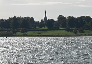
Edith Weston is a village and civil parish in the county of Rutland in the East Midlands of England. The population of the civil parish was 1,042 at the 2001 census, including Normanton and increasing to 1,359 at the 2011 census. It is on the south-eastern shore of Rutland Water and is home of the main sailing club and a fishing lodge. The village is named after Edith of Wessex (1029–1075), the queen of Edward the Confessor and sister of Harold Godwinson.

Exton is a village in Rutland, England. The population was 607 at the 2011 census. The civil parish was abolished in 2016 and merged with Horn to form Exton and Horn.

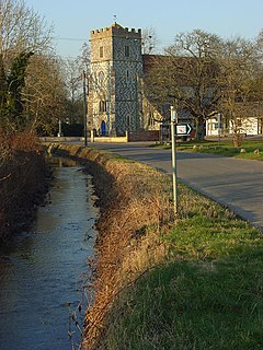
Greetham is a village and civil parish in the county of Rutland in the East Midlands of England.

Morcott is a village and civil parish in the county of Rutland in the East Midlands of England. The population at the 2001 census was 329 falling slightly to 321 at the 2011 census. It is located about 7 miles (11 km) south-east of the county town of Oakham on the A47 and A6121 roads. A prominent reconstructed windmill can be seen from both East and West-bound approaches to Morcott along the A47.

Normanton is a village and civil parish on the eastern shore of Rutland Water in the county of Rutland in the East Midlands of England. The population remained less than 100 at the 2011 census and was included in the civil parish of Edith Weston.

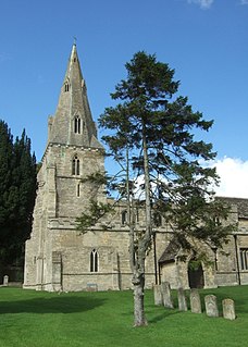
Ridlington is a village and civil parish in Rutland in the East Midlands of England. The population of the village was 202 at the time of the 2001 census, including Ayston, Leighfield and Wardley also increasing to 260 at the 2011 census.

Ambrosden is a village and civil parish in Cherwell, Oxfordshire, England, 3 miles (5 km) southwest of Bicester to which it is linked by the A41 road, and 13 miles (21 km) from Oxford. The 2011 Census recorded the parish's population as 2,248. The parish is bounded by the River Ray to the south, its tributary the River Bure to the west, the outskirts of Bicester to the north and field boundaries to the east.

Sledmere is a village in the East Riding of Yorkshire, England, about 7 miles (11 km) north-west of Driffield on the B1253 road.

Rufford is a village in West Lancashire, England, where the Leeds and Liverpool Canal, Liverpool, Ormskirk and Preston Railway, the A59 and the River Douglas meet.
Chitterne is a village and civil parish in the county of Wiltshire, in the south west of England. The village lies in the middle of Salisbury Plain, about 7 miles (11 km) east of the town of Warminster.

Gisburn is a village and civil parish within the Ribble Valley borough of Lancashire, England. Historically within the West Riding of Yorkshire, it lies 8 miles (13 km) northeast of Clitheroe and 11 miles (18 km) west of Skipton. The civil parish had a population of 506, recorded in the 2001 census, increasing to 521 at the 2011 Census.

Duddington is a small village in Northamptonshire, England. It is by the junction of the A47 and A43 roads, and is 9 kilometres (6 mi) southwest of the town of Stamford. The village is on the east bank of the River Welland which is the county boundary of Rutland.

George Fludyer (1761–1837) was an English politician, the Member of Parliament for Chippenham from 1782 to 1802, and for Appleby from 1818 to 1819.
John Henry Fludyer, 4th Baronet (1803–1896), generally known as Henry Fludyer, was a rare combination of Baronet and clergyman who restored the St Nicholas' Church in Thistleton, Rutland as a memorial to his three eldest children. He inherited the Baronetcy at a late age after his cousin and two elder brothers died without issue. He inherited the family seat at Ayston, a village where he was already Rector, and near which he seems to have spent most of his life. He died at age 92, having been connected to the parish of Ayston for nearly 70 years.


