Greycliffe Homestead

Last updated

Greycliffe Homestead
Greycliffe Homestead (2009).jpg
Greycliffe Homestead, 2009
Location 48 Gladstone Road, Biloela, Shire of Banana, Queensland, Australia
Coordinates 24°23′47″S150°31′11″E / 24.3963°S 150.5198°E / -24.3963; 150.5198 Coordinates: 24°23′47″S150°31′11″E / 24.3963°S 150.5198°E / -24.3963; 150.5198
Design period 1840s - 1860s (mid-19th century)
Builtc.1863 -
Official name: Greycliffe Homestead
Type state heritage (built)
Designated 21 October 1992
Reference no. 600017
Significant period 1860s (historical)
1860s-1870s (fabric)
Significant components residential accommodation - main house
Australia Queensland location map.svg
Red pog.svg
Location of Greycliffe Homestead in Queensland
Australia location map.svg
Red pog.svg
Greycliffe Homestead (Australia)

Greycliffe Homestead is a heritage-listed homestead at 48 Gladstone Road, Biloela, Shire of Banana, Queensland, Australia. It was built from c.1863 onwards . It was added to the Queensland Heritage Register on 21 October 1992. [1]

A homestead is a dwelling, especially a farmhouse, and adjacent outbuildings, typically on a large agricultural holding such as a ranch or station.

Shire of Banana Local government area in Queensland, Australia

The Shire of Banana is a local government area located in the Capricorn region of Queensland, Australia, inland from the regional city of Gladstone. The shire was named after the first township in the region (Banana), which in turn was named for the burial site of a huge dun coloured bullock named 'Banana'. The council sits in the town of Biloela, which is the largest town in the Shire.

Queensland North-east state of Australia

Queensland is the second-largest and third-most populous state in the Commonwealth of Australia. Situated in the north-east of the country, it is bordered by the Northern Territory, South Australia and New South Wales to the west, south-west and south respectively. To the east, Queensland is bordered by the Coral Sea and Pacific Ocean. To its north is the Torres Strait, with Papua New Guinea located less than 200 km across it from the mainland. The state is the world's sixth-largest sub-national entity, with an area of 1,852,642 square kilometres (715,309 sq mi).

Contents

History

Greycliffe Homestead is a slab dwelling formerly on Greycliffe pastoral station and relocated to Biloela where it has served as the headquarters of the Banana Shire Historical Society since 1979. [1]

Ludwig Leichhardt explored the Callide and Dawson Valleys in 1844. Thomas Archer took up Eidsvold pastoral run and Charles Archer moved further north settling in the region of what is now Biloela. Other European pastoralists soon followed them in the 1850s, when this district was still a part of New South Wales (prior to the separation of Queensland in 1859). In 1863 Frederick Barton took up Greycliffe. [1]

Ludwig Leichhardt German explorer of Australia

Friedrich Wilhelm Ludwig Leichhardt, known as Ludwig Leichhardt, was a German explorer and naturalist, most famous for his exploration of northern and central Australia.

Dawson River (Queensland) river in Queensland, Australia

The Dawson River is a river located in Central Queensland, Australia.

The Archer brothers were among the earliest European settlers in Queensland. They were explorers and pastoralists. Seven sons of William Archer, a Scottish timber merchant, they spent varying amounts of time in the colony of New South Wales, mainly in parts of what later became Queensland. A substantial number of locations in Queensland were either named by or for them. They were, in order of birth:

It is not certain when William Nott moved onto the run, but in 1871 he married Sophia Collins. Their first two children died, but in November 1875 Helen Brenda Nott was born and as she was the only one of their subsequent children not to have been born on Greycliffe, the Nott family may have moved to Greycliffe in 1876. In January 1877 Alfred David became the first of seven more children born on the property. In 1878 the lease was transferred to Frederick Brackner, but in 1879 Nott acquired the lease himself. In 1884 he took up further land and in later years further leases extended the run. [1]

The original form of the house was a large rectangular room with a fireplace at one end. This was extended and eventually included two bedrooms separated by a passage in the core section, an encircling verandah with subsidiary rooms and a detached kitchen. The rooms were ceiled with stretched calico and walls were decorated by gluing chintz directly to the timber. [1]

Fireplace device for firing solid fuels in residential buildings

A fireplace is a structure made of brick, stone or metal designed to contain a fire. Fireplaces are used for the relaxing ambiance they create and for heating a room. Modern fireplaces vary in heat efficiency, depending on the design.

Veranda roofed, open-air gallery or porch

A veranda or verandah is a roofed, open-air gallery or porch, attached to the outside of a building. A veranda is often partly enclosed by a railing and frequently extends across the front and sides of the structure.

Calico balanced plain-weave cotton or cotton-blend fabric, often with a small printed pattern

Calico is a plain-woven textile made from unbleached and often not fully processed cotton. It may contain unseparated husk parts, for example. The fabric is far less fine than muslin, but less coarse and thick than canvas or denim, but it is still very cheap owing to its unfinished and undyed appearance.

In 1903, William Nott died and the eldest of his surviving sons, William Ingliss, managed the property. His two brothers and a sister, Emma, served overseas in World War I while another sister, Jessie, helped to run the station. [1]

World War I 1914–1918 global war originating in Europe

World War I, also known as the First World War or the Great War, was a global war originating in Europe that lasted from 28 July 1914 to 11 November 1918. Contemporaneously described as "the war to end all wars", it led to the mobilisation of more than 70 million military personnel, including 60 million Europeans, making it one of the largest wars in history. It is also one of the deadliest conflicts in history, with an estimated nine million combatants and seven million civilian deaths as a direct result of the war, while resulting genocides and the 1918 influenza pandemic caused another 50 to 100 million deaths worldwide.

In the 1920s the homestead was repaired and the roof shingles were replaced by corrugated iron sheeting. In 1923, Frederic Nott and his family moved to Darling Plain and in 1924, Bill Nott also moved away, although Greycliffe remained in the family. In 1929 Sophia Nott died aged 83. Emma and a nephew, Robin Nott, lived on the property. In 1972 she died at the age of 92, being the last person to live in the homestead building. When Robin Nott also died, his wife and sons took over the running of the property. It was sold in the late 1970s. [1]

After the sale of Greycliffe station, the Banana Shire Historical Society feared that the vacant homestead might decay or catch fire. They therefore acquired the building in 1979 and removed it from the site in two sections. At the time this approach to preserving buildings was considered by many to be a valid way to save places valued by the community. It was relocated 37 kilometres (23 mi) away at Gladstone Road, Biloela where it became premises for the Society. It is open to the public by arrangement. The detached kitchen has not survived the move. [1]

Description

The former Greycliffe homestead is now located on the corner of Gladstone Road and Lawrence Street, Biloela. The site has several other buildings on it including a slab hut, a new timber shelter for machinery and a concrete toilet block. [1]

The homestead is a single storey timber building set on low timber stumps. The roof is hipped and clad in corrugated iron. The house is constructed of timber slabs on a pole frame and has an encircling verandah incorporating subsidiary rooms. There is a tourist office in the room on the front left hand side of the verandah. The rear verandah has storage rooms and a kitchen. At least one room has a modern steel security door and some rooms are lined with modern material. [1]

The core of the building consists of a large living room with a fireplace at one end. This has a simple timber mantelpiece and is brick lined. There are two bedrooms separated by a passage. The fabric ceilings have not survived the removal. There are timber steps to the front of the building and the rear is reached by a ramp. [1]

Heritage listing

Greycliffe Homestead was listed on the Queensland Heritage Register on 21 October 1992 having satisfied the following criteria. [1]

The place is important in demonstrating the evolution or pattern of Queensland's history.

Greycliffe homestead illustrates the pattern of early European exploration and settlement of Queensland where the development of pastoral properties preceded agriculture and the establishment of towns. As an early homestead in the Leichhardt Pastoral District, it has associations with the development of the pastoral industry in Queensland. [1]

The place is important in demonstrating the principal characteristics of a particular class of cultural places.

Greycliffe demonstrates the principal characteristics of an early homestead building constructed from materials found on the property and illustrates the building techniques traditionally used for such buildings. [1]

The place has a strong or special association with a particular community or cultural group for social, cultural or spiritual reasons.

The homestead is valued by the community as demonstrated by the project to preserve it as an important part of the history of the area, and it is associated with the historical society whose focus it has been since the late 1970s. [1]

The place has a special association with the life or work of a particular person, group or organisation of importance in Queensland's history.

Greycliffe homestead is associated with the Nott family who, as early pastoralists, contributed to the development of the area. [1]

Related Research Articles

Glenmore Homestead, Rockhampton

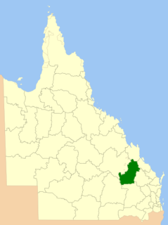
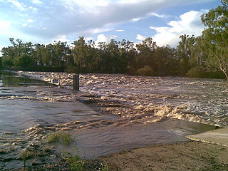
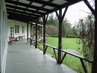
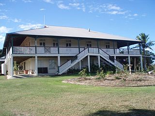
Glenmore Homestead is a heritage-listed homestead at Belmont Road, Parkhurst, Rockhampton Region, Queensland, Australia. It was built from c. 1858 to c. 1920. The homestead and associated buildings once belonged to pastoral run on the Fitzroy River, seven kilometres northwest of Rockhampton, Queensland. Originally much larger at 127 square miles the current size of the property is 20 acres (8.1 ha). It was added to the Queensland Heritage Register on 21 October 1992.

Canning Downs

Canning Downs was the first residential establishment built by a white person on the Darling Downs in Queensland, Australia. It is located a short drive from the town of Warwick and originally extended south east to Killarney and the McPherson Range. The area was first named after the British statesman George Canning by Allan Cunningham.

Bellevue Homestead

Bellevue Homestead is a heritage-listed homestead currently located in Coominya, Somerset Region, Queensland, Australia. It was built from c. 1872 to c. 1910. It was added to the Queensland Heritage Register on 21 October 1992.

Westbrook Homestead

Westbrook Homestead is a heritage-listed homestead at Coupers Road, Westbrook, Toowoomba Region, Queensland, Australia. It was built from 1864 to 1867. It was added to the Queensland Heritage Register on 21 October 1992.

Franklyn Vale Homestead

Franklyn Vale Homestead is a heritage-listed homestead at Franklin Vale Road, Mount Mort, City of Ipswich, Queensland, Australia. It was built in the early 1870s. It was added to the Queensland Heritage Register on 21 October 1992.

Ballandean Homestead

Ballandean Homestead is a heritage-listed homestead at Ballandean, Southern Downs Region, Queensland, Australia. It was built from c. 1840 to 1890s circa. It was added to the Queensland Heritage Register on 21 October 1992.

Kilcoy Homestead

Kilcoy Homestead is a heritage-listed homestead at Kilcoy-Murgon Road, Winya, Somerset Region, Queensland, Australia. It was built c. 1857. It was added to the Queensland Heritage Register on 21 October 1992.

Booubyjan Homestead

Booubyjan Homestead is a heritage-listed homestead at Booubyjan Road, Booubyjan, Gympie Region, Queensland, Australia. It was built from the 1860s to the 1870s circa. It was added to the Queensland Heritage Register on 21 October 1992.

Glengarry Homestead

Glengarry Homestead is a heritage-listed homestead at Gladstone-Monto Road, Boynedale, Gladstone Region, Queensland, Australia. It was built from c. 1894 to c. 1920. It was added to the Queensland Heritage Register on 21 October 1992.

Raglan Homestead

Raglan Homestead is a heritage-listed homestead at Raglan Station Road, Raglan, Gladstone Region, Queensland, Australia. It was built from c. 1857 to 1913. It is also known as Raglan Station. It was added to the Queensland Heritage Register on 21 October 1992.

Strathmore Homestead

Strathmore Homestead is a heritage-listed homestead at Strathmore Station on Strathmore Road, Springlands, Whitsunday Region, Queensland, Australia. It was built from the 1860s onward. It is also known as Strathmore Station. It was added to the Queensland Heritage Register on 13 November 2008.

Muralambeen Homestead

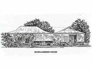
Muralambeen Homestead is a heritage-listed homestead off Bosworth's Road, Forrest Beach, Shire of Hinchinbrook, Queensland, Australia. It was built from c. 1881 to c. 1900. It was added to the Queensland Heritage Register on 25 February 2005.

Gunnawarra Homestead

Gunnawarra Homestead is a heritage-listed homestead at Gunnawarra Road, Gunnawarra, Tablelands Region, Queensland, Australia. It was built from 1878 to 1908. It was added to the Queensland Heritage Register on 21 October 1992.

Old Westmoreland Homestead

Old Westmoreland Homestead is a heritage-listed homestead at Westmoreland Station, Nicholson, Shire of Burke, Queensland, Australia. It was designed by Thomas Brassey McIntosh and built in c. 1882 by Thomas Brassey McIntosh. It was added to the Queensland Heritage Register on 31 July 2008.

Wylarah

Wylarah is a heritage-listed homestead at South Burrandowan Road, Ironpot, South Burnett Region, Queensland, Australia. It was built in 1891 by J Gibbs. It was added to the Queensland Heritage Register on 21 August 1992.

Burrandowan Station Homestead homestead at Kingaroy Road, Durong, South Burnett Region, Queensland, Australia

Burrandowan Station Homestead is a heritage-listed homestead at Kingaroy Road, Durong, South Burnett Region, Queensland, Australia. It was built from 1848 to c. 1927. It was added to the Queensland Heritage Register on 21 October 1992.

Kilbirnie Homestead historic house in Queensland

Kilbirnie Homestead is a heritage-listed homestead at Argoon-Kilburnie Road, Jambin, Shire of Banana, Queensland, Australia. It was built in 1884. It was added to the Queensland Heritage Register on 21 October 1992.

The Glebe Homestead

The Glebe Homestead is a heritage-listed homestead at Taroom-Cracow Road, Glebe near Taroom, Shire of Banana, Queensland, Australia. It was designed by Florence Mary Rigby and built c. 1920. It is also known as Broadwater. It was added to the Queensland Heritage Register on 23 March 2007.

Tarong Homestead

Tarong Homestead is a heritage-listed homestead at Cooyar Road, Tarong, South Burnett Region, Queensland, Australia. It was built from 1840s circa to 1890s circa. It was added to the Queensland Heritage Register on 21 October 1992.

Boondooma Homestead homestead at Mundubbera - Durong Road, Boondooma, South Burnett Region, Queensland

Boondooma Homestead is a heritage-listed homestead at Mundubbera - Durong Road, Boondooma, South Burnett Region, Queensland, Australia. It was built from the 1850s to the 1870s. It was added to the Queensland Heritage Register on 21 October 1992.

References

  1. 1 2 3 4 5 6 7 8 9 10 11 12 13 14 15 16 "Greycliffe Homestead (entry 600017)". Queensland Heritage Register . Queensland Heritage Council. Retrieved 1 August 2014.

Attribution

CC-BY-icon-80x15.png This Wikipedia article was originally based on "The Queensland heritage register" published by the State of Queensland under CC-BY 3.0 AU licence (accessed on 7 July 2014, archived on 8 October 2014). The geo-coordinates were originally computed from the "Queensland heritage register boundaries" published by the State of Queensland under CC-BY 3.0 AU licence (accessed on 5 September 2014, archived on 15 October 2014).

Commons-logo.svg Media related to Greycliffe Homestead at Wikimedia Commons