
Rocky Ford is a statutory city located in Otero County, Colorado, United States. The population was 3,957 at the 2010 census.

Faison is a town in Duplin County in the U.S. state of North Carolina. The population was 961 at the 2010 census.

The A90 road is a major north to south road in eastern Scotland, running from Edinburgh to Fraserburgh, through Dundee and Aberdeen. Along with the A9 and the A82 it is one of the three major north–south trunk roads connecting the Central Belt to the North.

Gros Islet District, one of 10 first order subdivision of the Caribbean island nation of Saint Lucia which includes the island's northernmost point, Cap Point and the notable Cap Estate, where the renowned St. Lucia Golf and Country Club is located. Whilst the town of Gros Islet is an important administrative centre, Rodney Bay is the main financial center of the district.

Charlotte is the largest parish of Saint Vincent and the Grenadines, situated on the eastern coast of the island of Saint Vincent. With an area of 149 km², its size is comparable to that of the British Virgin Islands.) The parish has the longest coastline of all the parishes and is also larger than the three smallest parishes combined. The parish possesses a very rough and rugged topography with very little flat land occurring towards the coast. as a result of these features, parts of the north of the parish cannot be accessed by a main road. Up until the building of a bridge over the Rabacca Dry River access to the north side of the river was not possible when rain caused the river to swell and make the path impassable.

The Trinity Centre is a one floor shopping centre in Aberdeen, Scotland. It has a two level car park. There are 408 spaces and the main entrance is on Wapping Street. Wider spaces are available for parents and children and the disabled. Car Valeting services are now also provided.

Banks o' Dee Football Club is a Scottish football club from the city of Aberdeen, that will play in the Scottish Highland Football League from the 2022–23 season.
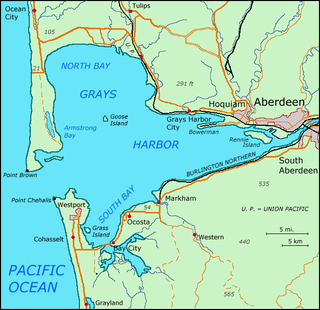
Grays Harbor is an estuarine bay located 45 miles (72 km) north of the mouth of the Columbia River, on the southwest Pacific coast of Washington state, in the United States of America. It is a ria, which formed at the end of the last ice age, when sea levels flooded the Chehalis River. The bay is 17 miles (27 km) long and 12 miles (19 km) wide. The Chehalis River flows into its eastern end, where the city of Aberdeen stands at that river's mouth, on its north bank, with the somewhat smaller city of Hoquiam immediately to its northwest, along the bayshore. Besides the Chehalis, many lesser rivers and streams flow into Grays Harbor, such as Hoquiam River and Humptulips River. A pair of low peninsulas separate it from the Pacific Ocean, except for an opening about two miles (3 km) in width. The northern peninsula, which is largely covered by the community of Ocean Shores, ends in Point Brown. Facing that across the bay-mouth is Point Chehalis, at the end of the southern peninsula upon which stands the town of Westport.

The Diocese of Aberdeen and Orkney is one of the seven dioceses of the Scottish Episcopal Church. Created in 1865, the diocese covers the historic county of Aberdeenshire, and the Orkney and Shetland island groups. It shares with the Roman Catholic Diocese of Aberdeen a Christian heritage that can be traced back to Norman times, and incorporates the ancient Diocese of Orkney, founded in 1035.

The Kirk of St Nicholas is a historic church located in the city centre of Aberdeen, Scotland. Up until the dissolution of the congregation on 31 December 2020, it was known as the "Kirk of St Nicholas Uniting". It is also known as "The Mither Kirk" of the city. As of 1 January 2021, the building falls under the care and maintenance of the General Trustees of the Church of Scotland.
The Shumatuscacant River is an 8.8-mile-long (14.2 km) river running through Abington and Whitman, Massachusetts. It forms part of the Taunton River Watershed.

Grays Harbor College is a public community college in Aberdeen, Washington. Founded in 1930, the college sits on a 120-acre (0.49 km2) campus overlooking the town of Aberdeen and its seaport on the edge of the Pacific Ocean. Additional "learning centers" are located in Raymond, Ilwaco, North Aberdeen, and Southside Aberdeen.
Lamar is a small, unincorporated community and census-designated place (CDP) in Aransas County, Texas, United States, 10 miles (16 km) north of Rockport and 40 miles (64 km) north of Corpus Christi. As of the 2010 census it had a population of 636. The community was named for Mirabeau B. Lamar, the second president of the Republic of Texas. This was a new CDP for the 2010 census.

Monchy is a town and second-order administrative division of Gros Islet District in the island nation of Saint Lucia. The town is located near the northern end of the island about 4 kilometres (2.5 mi) from Gros Islet, and about 7.9 kilometres (4.9 mi) from the capital, Castries.
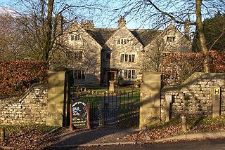
Hartington Hall is a much altered and extended 17th-century manor house at Hartington, Derbyshire, now a youth hostel.
Spring Bay is a hamlet in the Canadian province of Saskatchewan.

The Cruden Bay Hotel Tramway operated an electric tramway service between the Cruden Bay Hotel and Cruden Bay railway station between 1899 and 1940.

Girdle Ness Lighthouse is situated near Torry Battery on the Girdle Ness peninsula just south of the entrance to Aberdeen's harbour, in Scotland. It is an active light, managed by the Northern Lighthouse Board.
The Oscar was a whaling ship that was wrecked near Aberdeen, Scotland, on 1 April 1813. It was so close to the shore that families helplessly watched the ship's men struggle and drown, a few yards from safety. This disaster led to community funding for the bereaved families and is known in poem and art. It resulted in changes to bring safety in a new lighthouse for the headland, and a street in Torry was named Oscar Road.
The NESS Energy Project is an incinerator currently under construction in Aberdeen, UK. It is situated in East Tullos Industrial Estate on a site formerly used for gas storage.
