Greåker

Last updated
Nordic Paper's factory at Greaker, Norway. Nordic Paper 01.JPG
Nordic Paper's factory at Greåker, Norway.
Centre of Greaker seen from the fortress. Greaker.jpg
Centre of Greåker seen from the fortress.

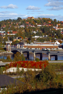
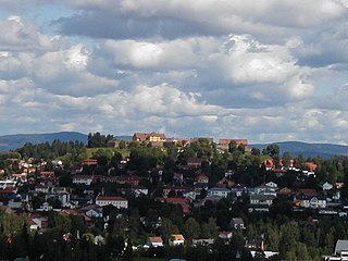
Greåker is a borough in the city of Sarpsborg, Norway, located 7 km west of the city centre. Before 1992 Greåker was a part of Tune municipality. It is situated at the river Glomma between Sarpsborg and Fredrikstad. [1]

Sarpsborg Municipality in Østfold, Norway

Sarpsborg[ˈsɑʂ.bɔr] or [ˈsɑrps.bɔrg], historically Borg, is a city and municipality in Østfold county, Norway. The administrative centre of the municipality is the city of Sarpsborg.

Norway constitutional monarchy in Northern Europe

Norway, officially the Kingdom of Norway, is a Nordic country in Northwestern Europe whose territory comprises the western and northernmost portion of the Scandinavian Peninsula; the remote island of Jan Mayen and the archipelago of Svalbard are also part of the Kingdom of Norway. The Antarctic Peter I Island and the sub-Antarctic Bouvet Island are dependent territories and thus not considered part of the kingdom. Norway also lays claim to a section of Antarctica known as Queen Maud Land.

Tune, Norway former municipality in Østfold county, Norway

Tune is a former municipality in Østfold county, Norway. The former municipality originally covered the current Sarpsborg municipality with the exception of Skjeberg and with the addition of Rolvsøy.

The borough of Greåker is the home of the Premier League Floorball team "Greåker Bulldogs". The team's home arena is the Tindlundhallen arena.

Greåker has been a site for diverse industry for decades, most notably in the area of paper production. The most notable remaining industry today[ when? ] is Nordic Paper's kraft paper mill by the Glomma river, which is the continuation of over a hundred years of various wood processing works (e.g. Greaker Cellulose, Greaker Industrier). [2]

Nordic Paper Swedish Paper and Pulp Company

Nordic Paper AS is a Norwegian industrial company, operating in Norway and Sweden. It was founded in 2001 when Peterson Scanproof, a branch of M. Peterson & Søn which consisted of production units in Greåker and Säffle, was merged with a paper factory in Geithus, owned by Norske Skog Union.

There is a fortress located in Greåker, built during the first decade of the 20th century. It was one of several fortresses built along the Norwegian/Swedish border during this period, in preparation for a potential war between Norway and Sweden. Norway was struggling to leave the union with Sweden, which had lasted since 1814. This war never came to happen, and the fortress was partially disabled. During World War II, the Germans attacked the fortress, coming across the river Visterflo, which unites with its source, Glomma, again at Greåker. Today[ when? ] the fortress is in poor condition, and used as a look-out point over Fredrikstad and the southern parts of Sarpsborg.

Norway–Sweden border international border between Norway and Sweden

The Norway–Sweden border is a 1,630-kilometre (1,010 mi) long land national border, and the longest border for both Norway and Sweden.

Dissolution of the union between Norway and Sweden the dissolution of the United Kingdoms of Sweden and Norway

The dissolution of the union between the kingdoms of Norway and Sweden under the House of Bernadotte, was set in motion by a resolution of the Norwegian Parliament on 7 June 1905. Following some months of tension and fear of war between the neighbouring nations – and a Norwegian plebiscite held on 13 August which overwhelmingly backed dissolution – negotiations between the two governments led to Sweden's recognition of Norway as an independent constitutional monarchy on 26 October 1905. On that date, King Oscar II renounced his claim to the Norwegian throne, effectively dissolving the United Kingdoms of Sweden and Norway, and this event was swiftly followed, on 18 November, by the accession to the Norwegian throne of Prince Carl of Denmark, taking the name of Haakon VII.

Related Research Articles

Fredrikstad Municipality in Østfold, Norway

Fredrikstad is a city and municipality in Østfold county, Norway. The administrative centre of the municipality is the city of Fredrikstad.

Østfold County (fylke) of Norway

Østfold[²œstfɔl](listen) is a county in southeastern Norway, bordering Akershus and southwestern Sweden, while Buskerud and Vestfold are on the other side of Oslofjord. The county's administrative seat is Sarpsborg.

Kongsvinger Municipality in Hedmark, Norway

Kongsvinger  is a town and is a municipality in Hedmark county, Norway. It is part of the traditional region of Glåmdal. The administrative centre of the municipality is the town of Kongsvinger.

Elverum Municipality in Hedmark, Norway

Elverum  is a city and municipality in Hedmark county, Norway. It is part of the traditional region of Østerdalen. The administrative centre of the municipality is the town of Elverum. The municipality of Elverum was established on 1 January 1838 . Elverum lies at an important crossroads, with Hamar to the west, Kongsvinger to the south, and Trysil on the Swedish border to the northeast. It is bordered on the north by Åmot municipality, in the northeast by Trysil municipality, in the southeast by Våler, and in the west by Løten.

Fredriksten fort at Halden on the norwegian-swedish border

Fredriksten is a fortress in the city of Halden in Norway.

Fredrikstad FK association football club in Fredrikstad, Norway

Fredrikstad Fotballklubb is a Norwegian football club from the town of Fredrikstad. With nine league championships and eleven Norwegian Cup wins, FFK is one of the most successful clubs in Norwegian football. The club was founded in 1903.

The Lower Glomma Region is a statistical metropolitan region in Østfold in southeastern Norway. It is centered on the cities of Fredrikstad and Sarpsborg near the Swedish border. It is located at the end of the Glomma River.

Fredrikstad Fortress

Fredrikstad fortress was a fortification in Fredrikstad, Norway. It was the base of the Østfold Regiment, with defence related responsibilities for the east side of Oslofjord.

Sannesund Bridge bridge in Norway

Sannesund Bridge is a motorway cantilever bridge that crosses Glomma river in Østfold, Norway. It extends from Alvim in Sarpsborg to Årum in Fredrikstad.The bridge is 1528 metres long, the longest span is 139 metres, and the maximum clearance is 30 metres. The bridge has 48 spans.

Kongsvinger Fortress building in Kongsvinger, Hedmark, Norway

Kongsvinger Fortress is located in the city and municipality of Kongsvinger in the county of Hedmark, Norway. It is situated on a hill west and north of the Glomma river, standing astride the ancient Vinger Royal Road, which connected Norway and Värmland, Sweden as well as on the north-south Norwegian route along the Glomma. As Kongsvinger formed a key junction point for these routes, fortifications were constructed there to protect against invasion from the east.

Elvestad is a well-known traffic junction area and a village in the Hobøl municipality in the Østfold county, Norway. It is where the "Riksvei" (country road route 120 and Europe Way E18 cross each other. Riksvei 120 goes between Gardermoen airport via Gjerdrum municipality in the Akershus county and Moss City in the Østfold county.

Varteig

Varteig is a village in Sarpsborg and a former municipality in Østfold County, Norway.

Borge, Østfold human settlement

Borge is a parish and former municipality in Østfold county, Norway. Today it is located in the northeast part of Fredrikstad municipality, near the border with Sarpsborg.

Fetsund Village in Akershus, Norway

Fetsund forms the center of the municipality Fet in the county of Akershus, Norway. The name comes from the local geography, Fet means "where water meets grass". As for the -sund part, it simply means 'strait, inlet'. Accordingly, Fetsund is located at the strait of Glomma, Norway's largest river, just before it enters Øyeren nature reservation, and this is the place the logging industry in years past pulled the logs out of the water for transport to steam sawmills.

Yven is a borough in the city of Sarpsborg in Østfold, Norway. It is located east of the city centre on the west side of the Glomma river between Sarpsborg and Fredrikstad. Yven was previously assigned to the former municipality of Tune. As of 1885, the village was estimated to have had 297 inhabitants.

Greaker Industrier AS was a Norwegian industrial company, which ran a paper mill in Sarpsborg, Norway.

The 1st Division is a former unit in the Norwegian Army, responsible for the defence of Eastern Norway along with 2nd Division.

References

  1. Sigurd H. Unneberg; Egil Kristoffer Sanner (1953). Botne bygdebok: Gårds- og slekthistorie (in Norwegian). Harald Lyche. Retrieved 15 August 2013.
  2. "Greåker". Nordic Paper. Retrieved 2013-08-15.

Coordinates: 59°16′N11°02′E / 59.267°N 11.033°E / 59.267; 11.033

Geographic coordinate system Coordinate system

A geographic coordinate system is a coordinate system that enables every location on Earth to be specified by a set of numbers, letters or symbols. The coordinates are often chosen such that one of the numbers represents a vertical position and two or three of the numbers represent a horizontal position; alternatively, a geographic position may be expressed in a combined three-dimensional Cartesian vector. A common choice of coordinates is latitude, longitude and elevation. To specify a location on a plane requires a map projection.