
The economy of Afghanistan is listed as the 124th largest in the world in terms of nominal gross domestic product (GDP), and 102nd largest in the world in terms of purchasing power parity (PPP). With a population of around 41 million people, Afghanistan's GDP (nominal) stands at $14.58 billion as of 2021, amounting to a GDP per capita of $363.7. Its annual exports exceed $2 billion, with agricultural, mineral and textile products accounting for 94% of total exports. The nation's total external debt is $1.4 billion as of 2022.

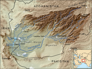
The Helmand River is the longest river in Afghanistan and the primary watershed for the endorheic Sistan Basin. It emerges in the Sanglakh Range of the Hindu Kush mountains in the northeastern part of Maidan Wardak Province, where it is separated from the watershed of the Kabul River by the Unai Pass. The Helmand feeds into the Hamun Lake on the border between Afghanistan and Iran.

Helmand, also known as Hillmand, in ancient times, as Hermand and Hethumand, is one of the 34 provinces of Afghanistan, in the south of the country. It is the largest province by area, covering 58,584 square kilometres (20,000 sq mi) area. The province contains 18 districts, encompassing over 1,000 villages, and roughly 1,446,230 settled people. Lashkargah serves as the provincial capital. Helmand was part of the Greater Kandahar region until made into a separate province by the Afghan government in the 20th century.

Lashkargāh, historically called Bost or Boost, is a city in southwestern Afghanistan and the capital of Helmand Province. It is located in Lashkargah District, where the Arghandab River merges into the Helmand River. The city has a population of 201,546 as of 2006. Lashkargah is linked by major roads with Kandahar to the east, Zaranj on the border with Iran to the west, and Farah and Herat to the north-west. It is mostly very arid and desolate. However, farming does exist around the Helmand and Arghandab rivers. Bost Airport is located on the east bank of the Helmand River, five miles north of the junction of the Helmand and Arghandab rivers. Because of the trading hubs, it is Afghanistan's second largest city in size, after Kabul and before Kandahar.

Lake Hāmūn, or the Hamoun Oasis, is a seasonal lake and wetlands in the endorheic Sīstān Basin in the Sistan region on the Afghanistan–Iran border. In Iran, it is also known as Hāmūn-e Helmand, Hāmūn-e Hīrmand, or Daryācheh-ye Sīstān.

The Arghandab is a river in Afghanistan, about 400 km (250 mi) in length. It rises in Ghazni Province, west of the city of Ghazni, and flows southwest, passing near the city of Kandahar, before joining the Helmand River 30 km (19 mi) below the town of Grishk. In its lower course, it is much used for irrigation, under the control of the Helmand and Arghandab Valley Authority, and the valley is cultivated and populous; yet the water is said to be somewhat brackish. It is doubtful whether the ancient Arachotus is to be identified with the Arghandab or with its chief confluent the Tarnak, which joins it on the left 50 km (31 mi) southwest of Kandahar. The Tarnak, which flows south of Kandahar, is much shorter and less copious.
Daman District is situated in the central part of the Kandahar Province, Afghanistan. It borders Panjwai and Kandahar districts to the west, Shah Wali Kot District to the north, Zabul Province to the northeast, Arghistan and Spin Boldak districts to the east and Reg District to the south. The population is 30,700 (2006). The center is the village of Daman, located in the central part of the district. The area is irrigated by the Helmand and Arghandab Valley Authority.
Grishk District, also called Nahri Saraj District, is a district in Helmand Province in southern Afghanistan. Its principal municipality is Grishk. Grishk Dam is located in the district.

Maiwand is a village in Afghanistan within the Maywand District of Kandahar Province. It is located 50 miles northwest of Kandahar, on the main Kandahar–Lashkargah road.

Grishk, also spelled Gereshk, is the new name of Zamindawar which is named after the invasion the region by Nader Afshar army and given to Ghilji tribe in 18th century. Grishk a town in Grishk District of Helmand province, geographically located along the Helmand River in Afghanistan, some 120 km (75 mi) northwest of Kandahar, at 817 metres (2,680 ft) altitude. Upstream lies the Kajaki Dam which diverts water to the Boghra Irrigation Canal, an essential infrastructure for the region's crops. Grishk Dam is also nearby. Grishk was originally built around a fort on the east bank of the river but was later rebuilt on the west. The fort was twice captured by the British: first in the First Anglo-Afghan War and again in 1879. In both cases the fort was later abandoned. Grishk has a population of about 48,546 and has a hospital and a school of engineering which was built back in 1957.
Sher Mohammed Akhundzada is an Alizai tribal leader who was the Governor of Helmand in Afghanistan from 2001 to 2005. As governor, he implemented various agricultural projects in Helmand, including canal excavation from the Kajaki dam for irrigation and electricity generation projects. He was deeply involved in opium production and smuggling, leading to his removal from office by the Afghan government in 2005 after lobbying by the British, who were leading counter-narcotic efforts in Afghanistan at the time. He was succeeded as governor of Helmand by Mohammad Daoud.

The Kajaki Dam is "an earth and rockfill embankment type dam" located on the Helmand River in the Kajaki District of Helmand Province in Afghanistan, about 161 km (100 mi) northwest of Kandahar. It has a hydroelectric power station, which is operated by the Helmand and Arghandab Valley Authority through the Ministry of Energy and Water.

Nawzad is a small town, the centre of Nawzad District in Helmand Province, Afghanistan. It is located at 32.4000°N 64.4667°E at an altitude of 1221 metres ASL. It was the site of the Battle of Nawzad.

Operation Achilles was a NATO operation, part of the War in Afghanistan. Its objective was to clear Helmand province of the Taliban. The operation began on March 6, 2007. The offensive is the largest NATO-based operation in Afghanistan to date. NATO officials reported that, contrary to previous operations, Taliban fighters were avoiding direct confrontation in favor of guerilla tactics.
The following lists events that happened during 1953 in Afghanistan.

Operation Eagle's Summit was a military operation conducted by ISAF and Afghan National Army troops, with the objective of transporting a 220-tonne turbine to the Kajaki Dam in Helmand Province through territory controlled by Taliban insurgents. Ending in success for the coalition, it involved many British troops, and was said to have been one of the largest logistical operations carried out by the British Army since World War II. The operation took its name from the eagle pictured on the insignia of the 16th Air Assault Brigade.

Marjah is an agricultural town in southern Afghanistan. It has been reported to have a population between 80,000 and 125,000, but some sources argue that its population is much smaller and is spread across 80 to 125 km2, an area larger than Cleveland or Washington, D.C. Another source described Marjah as "a cluster of villages" and "a community of 60,000 persons". The town sits in Nad Ali District of Helmand Province, southwest of the provincial capital Lashkar Gah.
The Helmand and Arghandab Valley Authority (HAVA) based in Lashkar Gah, Afghanistan, originally named the Helmand Valley Authority (HVA) until its expansion in 1965, was established on December 4, 1952, as an agency of the Afghan Government. The agency was modeled on the Tennessee Valley Authority in the United States, with a remit covering lands in Farah Province, Ghazni Province, Helmand Province, Herat Province, and Kandahar Province.
Kamal Khan Dam is a hydroelectric and irrigation dam project on the Helmand River in Chahar Burjak District of Nimruz Province in south-western Afghanistan. It is located about 95 km to the southeast of Zaranj. Construction work on the dam officially began in 1974 but after the 1978 Saur Revolution, the Americans involved in the construction were compelled to leave Afghanistan and the project was abandoned. It was recently completed.
