Trifels Castle is a reconstructed medieval castle at an elevation of 500 m (1,600 ft) near the small town of Annweiler, in the Palatinate region of southwestern Germany. It is located high above the Queich valley within the Palatinate Forest on one peak of a red sandstone mountain split into three. Trifels Castle is on the peak of the Sonnenberg, and on both of the other two rock elevations there are castle ruins: Anebos Castle and Scharfenberg Castle.
Franz Ullrich (1830–1891) was a German industrialist, and co-founder of the "Gebrüder Ullrich" in the Rhineland-Palatinate.
Johannes Anton Ullrich (1826–1895) was a German industrialist, inventor, and co-founder of the "Gebrüder Ullrich" in the Rhineland-Palatinate.

Albersweiler is a municipality in the Südliche Weinstraße district, in Rhineland-Palatinate, Germany. It is part of the Verbandsgemeinde Annweiler am Trifels.

Gossersweiler-Stein is a municipality in Südliche Weinstraße district, in Rhineland-Palatinate, western Germany.

Ramberg is a municipality in Südliche Weinstraße district, in Rhineland-Palatinate, western Germany.
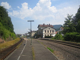
Annweiler am Trifels is a Verbandsgemeinde in the Südliche Weinstraße district, in Rhineland-Palatinate, Germany. The seat of the municipality is in Annweiler am Trifels.

The Queich is a tributary of the Rhine, which rises in the southern part of the Palatinate Forest, and flows through the Upper Rhine valley to its confluence with the Rhine in Germersheim. It is 52 kilometres (32 mi) long and is one of the four major drainage systems of the Palatinate Forest along with the Speyerbach, Lauter and Schwarzbach. The Queich flows through the towns Hauenstein, Annweiler am Trifels, Siebeldingen, Landau, Offenbach an der Queich and Germersheim.

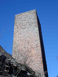
The Asselstein is a rock pinnacle or tower near the village of Annweiler am Trifels in the Southern Palatinate in western Germany.
The Wasgau is a Franco-German hill range in the German state of Rhineland-Palatinate and the French departments of Bas-Rhin and Moselle. It is formed from the southern part of the Palatine Forest and the northern part of the Vosges mountains, and extends from the River Queich in the north over the French border to the Col de Saverne in the south.

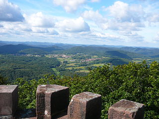
The Rehberg is a prominent hill, 576.8 m above sea level (NHN), in the German state of Rhineland-Palatinate. After the Grand Wintersberg in French North Alsace, the Rehberg is the second highest hill in the Wasgau, the Franco-German region that forms the southern part of the Palatine Forest and runs from the valley of the River Queich to the Col de Saverne. The Rehberg is also the highest hill on German soil in the Wasgau. As part of the Palatine Forest-North Vosges Biosphere Reserve it has been placed under special protection measures.
William Lovell Church of England Academy is a coeducational Church of England secondary school with academy status, located in Stickney in the English county of Lincolnshire.
Scharfenberg Castle, is the ruin of a medieval rock castle in the Palatine Forest in the German state of Rhineland-Palatinate. It is situated above the small South Palatine town of Annweiler.

The Hohenberg is a 552 m above sea level (NN) high hill in the Palatinate Forest, in the municipalities of Birkweiler, Queichhambach and Siebeldingen. At its summit is an observation tower, a refuge hut and starting ramps for hang gliders.

The Frankenburg is a natural monument with the ruins of a rock castle in the county of Südliche Weinstraße in the German state of Rhineland-Palatinate. It lies above the Modenbach valley on a rocky outcrop of the Frankenberg called the Frankenfelsen and was built to guard the road opposite Meistersel Castle.

The Dernbach is a river in the county of Südliche Weinstraße in the German state of Rhineland-Palatinate. It is 7.46 kilometres long and forms the left-hand, northern headstream of the Eisbach.
The Eisbach is a left-hand, northern tributary of the River Queich in the county of Südliche Weinstraße in the German state of Rhineland-Palatinate. It is 1.5 km (1 mi) long, or 10.48 km (7 mi) long if the Eußerbach is counted.