The Palatinate Forest, sometimes also called the Palatine Forest, is a low-mountain region in southwestern Germany, located in the Palatinate in the state of Rhineland-Palatinate. The forest is a designated nature park covering 1,771 km2 and its highest elevation is the Kalmit.

Wilgartswiesen is a municipality in Südwestpfalz district, in Rhineland-Palatinate, western Germany.

The Devil's Table in Hinterweidenthal is a 14 metre high mushroom rock in the German part of the Wasgau region, the southern Palatine Forest in the state of Rhineland-Palatinate). Thanks to its location in the territory of the village of Kaltenbach - formerly part of Wilgartswiesen – it is often called the Kaltenbach Devil's Table, especially in old literary sources. It is larger and better known than the Devil's Table of Salzwoog, which is only 5 kilometres away to the southwest.
The Wasgau is a Franco-German hill range in the German state of Rhineland-Palatinate and the French departments of Bas-Rhin and Moselle. It is formed from the southern part of the Palatine Forest and the northern part of the Vosges mountains, and extends from the River Queich in the north over the French border to the Col de Saverne in the south.

The Rehberg is a prominent hill, 576.8 m above sea level (NHN), in the German state of Rhineland-Palatinate. After the Grand Wintersberg in French North Alsace, the Rehberg is the second highest hill in the Wasgau, the Franco-German region that forms the southern part of the Palatine Forest and runs from the valley of the River Queich to the Col de Saverne. The Rehberg is also the highest hill on German soil in the Wasgau. As part of the Palatine Forest-North Vosges Biosphere Reserve it has been placed under special protection measures.

The Bobenthaler Knopf is a hill, 534 m above sea level, in the southeastern Wasgau, the name given to the region covering the southern part of the Palatine Forest in Germany and the northern part of the Vosges in France.

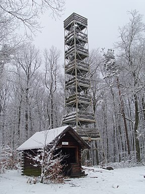
The Eckkopf is a 516 metre-high hill in the Palatine Forest in the Germany state of Rhineland-Palatinate. It lies about 3 km west of the small Palatine town of Deidesheim in the Haardt, as the eastern edge of the Palatine Forest is called. It has a 25 metre high observation tower called the Eckkopf Tower (Eckkopfturm).

The rock castle of Neudahn, in the southwestern Palatine Forest in the German state of Rhineland-Palatinate, is located at the northern end of an elongated ridge near the town of Dahn. The heart of the castle is situated on one of the sandstone rock outcrops that are typical of the Dahner Felsenland region.

The Bride and Groom is a double rock pinnacle, about 26 metres (85 ft) high, near the small German town of Dahn in the state of Rhineland-Palatinate and in the southern Palatine Forest, the German half of the Wasgau region.

The Betzenberg is a 285-metre-high hill in the German city of Kaiserslautern. It rises about 50 metres above the city and gives its name to the quarter in which it stands. It was well known because it also gave its name to what is now the Fritz Walter Stadium.
The Südliche Weinstraße Wildlife Park is located in the Wasgau, a region on the Franco-German border that forms the southern part of the Palatine Forest and the northern part of the Vosges, near the village of Silz in the south of the state of Rhineland-Palatinate. The park is not named after the German Wine Route which passes about 6 kilometres away, but after the county of Südliche Weinstraße. The tourist attraction receives about 100,000 visitors annually.
Scharfenberg Castle, is the ruin of a medieval rock castle in the Palatine Forest in the German state of Rhineland-Palatinate. It is situated above the small South Palatine town of Annweiler.

The Peterskopf, near the Palatine county town of Bad Dürkheim in the German state of Rhineland-Palatinate, is a 487-metre-high hill in the Haardt mountains. On its summit is the Bismarck tower.
The Erlenbach is a stream, over 9 km long, in the South Palatine Wasgau region of the German state of Rhineland-Palatinate. It is a left tributary of the Lauter which, here in its upper reaches is still called the Wieslauter.

The Nestelberg is a 402-metre-high hill in the Dahner Felsenland in the Wasgau, a region that comprises the southern part of the Palatine Forest in the German state of Rhineland-Palatinate and the northern part of the French Vosges in the departments of Bas-Rhin and Moselle.
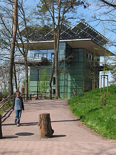
The Biosphere House in the village of Fischbach bei Dahn in the German state of Rhineland-Pfalz is a nature experience centre and important regional tourist attraction.

The Bichtenberg is a 400-metre-high hill in the western Wasgau, a region on the Franco-German border that includes the southern part of the Palatine Forest and the northern part of the Vosges. Its northwestern flank is in the parish of Lemberg, its southwestern flank in the parish of Dahn. To the north is the Lemberg hamlet of Salzwoog. Three kilometres west lies the Salzwoog Devil's Table.

The Hohe Derst is a hill, 561 metres above sea level, in the Palatine Forest of southwest Germany. It lies within the Wasgau region and is the highest point of the Mundat Forest.