Related Research Articles

Botswana is a landlocked country located in Southern Africa, north of South Africa. Botswana occupies an area of 581,730 square kilometres (224,610 sq mi), of which 566,730 km2 (218,820 sq mi) are land. Botswana has land boundaries of combined length 4,347.15 kilometres (2,701.19 mi), of which the constituent boundaries are shared with Namibia, for 1,544 km (959 mi); South Africa 1,969 km (1,223 mi); Zimbabwe, 834 km (518 mi) and Zambia, 0.15 km (0.093 mi). Much of the population of Botswana is concentrated in the eastern part of the country.

The Limpopo River rises in South Africa and flows generally eastward through Mozambique to the Indian Ocean. The term Limpopo is derived from Rivombo (Livombo/Lebombo), a group of Tsonga settlers led by Hosi Rivombo who settled in the mountainous vicinity and named the area after their leader. The river has been called Vhembe by local Venda communities of the area where now that name has been adopted by the South African government as its District Municipality in the north, a name that was also suggested in 2002 as a possible name to be adopted for the Province but was voted against. The river is approximately 1,750 kilometres (1,087 mi) long, with a drainage basin 415,000 square kilometres (160,200 sq mi) in size. The mean discharge measured over a year is 170 m3 per second at its mouth. The Limpopo is the second largest river in Africa that drains to the Indian Ocean, after the Zambezi River.

Limpopo is the northernmost province of South Africa. It is named after the Limpopo River, which forms the province's western and northern borders. The capital and largest city in the province is Polokwane, while the provincial legislature is situated in Lebowakgomo.

Gaza is a province of Mozambique. It has an area of 75,709 km2 and a population of 1,422,460, which is the least populous of all the provinces of Mozambique.
Kgatleng is one of the districts of Botswana, coterminous with the homeland of the Bakgatla people. Its capital is Mochudi, the hometown of protagonist Precious Ramotswe in Alexander McCall Smith's popular The No. 1 Ladies' Detective Agency series. According to the 2001 Census, Kgatleng had a population of 73,507 people.

Central is the largest of Botswana's districts in terms of area and population. It encompasses the traditional homeland of the Bamangwato people. Some of the most politically connected Batswana have come from the Central District, including former President Sir Seretse Khama, former President Festus Mogae, and former President Lt. General Seretse Ian Khama. The district borders the Botswanan districts of Chobe in the north, North-West in the northwest, Ghanzi in the west, Kweneng in southwest, Kgatleng in the south and North-East in the northeast, as well as Zimbabwe also in the northeast and South Africa in the southeast.
The Vhembe District Municipality is one of the 5 districts of the Limpopo province of South Africa. It is the northernmost district of the country and shares its northern border with the Beitbridge District in Zimbabwe and on the east with the Gaza Province in Mozambique. Vhembe consists of all the territories that were part of the former Venda Bantustan; however, two large densely populated districts of the former Tsonga homeland of Gazankulu, in particular, Hlanganani and Malamulele, were also incorporated into the municipality, hence the ethnic diversity of the district. The seat is Thohoyandou, the capital of the former Venda Bantustan. According to 2011 census, the majority of the municipality's 800,000 inhabitants spoke TshiVenda as their mother language, while 400,000 spoke Xitsonga as their home language. However, the Tsonga people form the majority south of the Levubu River, while the Venda are the minority south of Levubu at 15%. The Sepedi speakers number 27,000. The district code is DC34.

The Shashe River is a major left-bank tributary of the Limpopo River in Zimbabwe. It rises northwest of Francistown, Botswana and flows into the Limpopo River where Botswana, Zimbabwe and South Africa meet. The confluence is at the site of the Greater Mapungubwe Transfrontier Conservation Area.

Mapungubwe National Park is a national park in the Limpopo Province, South Africa. The park protects the historical site of Mapungubwe Hill, which was the capital of the Kingdom of Mapungubwe, as well as the wildlife and riverine forests along the Limpopo River. The Mapungubwe Hill was the site of a community dating back to the Iron Age. Evidence has shown that it was a prosperous community. Archaeologists also uncovered the famous Golden Rhinoceros of Mapungubwe figurine from the site.
The Kalanga or BaKalanga are a southern Bantu ethnic group mainly inhabiting Matebeleland in Zimbabwe, northern Botswana, and parts of the Limpopo Province in South Africa.

The N11 is a national route in South Africa which runs from the Botswana border at Groblersbrug, through Mokopane, Middelburg, Ermelo and Newcastle to end at the N3 just after Ladysmith.
Drainage Basin A, is one of the drainage basins of South Africa. The main river in this system is the Limpopo River. It is subdivided into 9 sub-drainage basins.

The Notwane River is a river in southeastern Botswana. Certain sections of its course form the international boundary with South Africa. Its mouth is at the head of the Limpopo River. It has a catchment area of 18,053 square kilometers.
Limpopo Valley Airfield is an airport serving the Northern Tuli Game Reserve, an area of public and private game reserves in eastern Botswana. The airport is owned by Mashatu Game Reserve with a superseded ICAO code of FBLV.
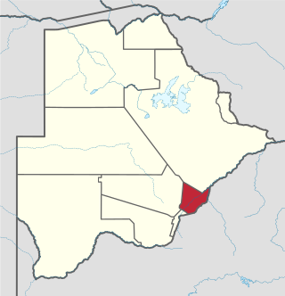
The Bobirwa Subdistrict is a jurisdiction in Botswana. It is populated by the Babirwa (Ba-Birwa) people who came from Transvaal in present-day South Africa.

The border between Botswana and South Africa is 1,969 kilometres (1,223 mi) long. More than 90% of the border follows rivers, including the Nossob, Molopo, Marico and Limpopo.

The border between South Africa and Zimbabwe is 225 kilometres (140 mi) long, and follows the median line of the Limpopo River.
Pontdrif is a border crossing between South Africa and Botswana on the Limpopo River in Limpopo. The borderpost is situated just west of Mapungubwe National Park.
Stockpoort is a border crossing between South Africa and Botswana in the Limpopo province. On the Botswana side the post is known as Parr's Halt. The Limpopo River separates the border posts.

The Soutpansberg Military Area (SMA) Headquarters was situated in Messina in the Northern Province of South Africa. The size of the area for which the SMA was responsible for was approximately 4,040 square kilometres (1,560 sq mi).
References
- ↑ "South African Ports of entry". Archived from the original on 28 August 2015. Retrieved 22 August 2015.