Groeneveld, Netherlands

Last updated
Coats of arms to Groeneveld Groeneveld COA.png
Coats of arms to Groeneveld

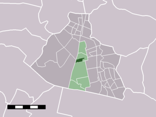
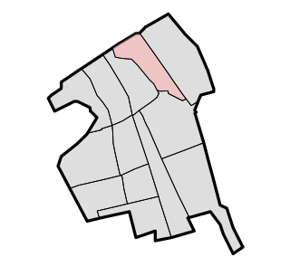
Groeneveld is a former municipality in the Dutch province of South Holland. It was located to the west of the city of Delft. The municipality covered the Groeneveldse Polder, northwest of De Lier, and contained no towns or villages; only the hamlet of Lierhand.

Netherlands Constituent country of the Kingdom of the Netherlands in Europe

The Netherlands, sometimes incorrectly called Holland, is a country located in Northwestern Europe with some overseas territories in the Caribbean. In Europe, it consists of 12 provinces that border Germany to the east, Belgium to the south, and the North Sea to the northwest, with maritime borders in the North Sea with those countries and the United Kingdom. Together with three island territories in the Caribbean Sea—Bonaire, Sint Eustatius and Saba—it forms a constituent country of the Kingdom of the Netherlands. The official language is Dutch, but a secondary official language in the province of Friesland is West Frisian. In the northern parts of the country, Low German is also spoken.

South Holland Province of the Netherlands

South Holland is a province of the Netherlands with a population of just over 3.6 million as of 2015 and a population density of about 1,300/km2 (3,400/sq mi), making it the country's most populous province and one of the world's most densely populated areas. Situated on the North Sea in the west of the Netherlands, South Holland covers an area of 3,403 km2 (1,314 sq mi), of which 585 km2 (226 sq mi) is water. It borders North Holland to the north, Utrecht and Gelderland to the east, and North Brabant and Zeeland to the south. The provincial capital is The Hague, while its largest city is Rotterdam.

Delft City and municipality in South Holland, Netherlands

Delft is a city and municipality in the province of South Holland, Netherlands. It is located between Rotterdam, to the southeast, and The Hague, to the northwest. Together with them, it is part of both Rotterdam–The Hague metropolitan area and the Randstad.

The municipality of Groeneveld was split off from 't Woud in 1817, and only existed until 1855, when it became part of Hof van Delft. [1]

t Woud Village in Gelderland, Netherlands

't Woud is a village in the Dutch province of Gelderland. It is a part of the municipality of Nijkerk, and lies about 12 km east of Amersfoort.

Hof van Delft neighborhood

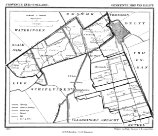
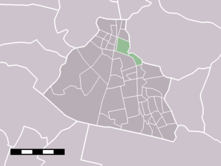
Hof van Delft is a former municipality in the Dutch province of South Holland. It was located to the west of the city of Delft, and covered the villages of Den Hoorn, Abtswoude, and 't Woudt.

Related Research Articles

Steenwijk City in Overijssel, Netherlands

Steenwijk is a city in the Dutch province of Overijssel. It is located in the municipality of Steenwijkerland. It is the largest town of the municipality.

Krommenie Place in Noord-Holland, Netherlands

Krommenie is a town in the Dutch province of North Holland. It is a part of the municipality of Zaanstad, and lies about 15 km northeast of Haarlem.

Westzaan Place in Noord-Holland, Netherlands

Westzaan is a town in the Dutch province of North Holland. It is a part of the municipality of Zaanstad, and lies about 13 km northeast of Haarlem.

Wormerveer Place in Noord-Holland, Netherlands

Wormerveer is a town in the Dutch province of North Holland. It is a part of the municipality of Zaanstad, and lies about 13 km northwest of Amsterdam.

Delfshaven former borough of Rotterdam

Delfshaven is a borough of Rotterdam, Netherlands, on the right bank of river Nieuwe Maas. It was a separate municipality until 1886.

Pijnacker is a town in the Dutch province of South Holland. It is located about 4 km east of the city of Delft, in the municipality of Pijnacker-Nootdorp.

Nootdorp Place in South Holland, Netherlands

Nootdorp is a town in the Dutch province of South Holland. It is located approximately 2 km to the east of Delft and about 6 km southeast of the centre of The Hague. Nootdorp was a separate municipality until 2002, when it merged with Pijnacker to form Pijnacker-Nootdorp.

Badhoevedorp Place in North Holland, Netherlands

Badhoevedorp is a town in the Dutch province of North Holland. It is a part of the municipality of Haarlemmermeer, and lies next to the Ringvaart around Haarlemmermeer at the side of the polder bordering Amsterdam / Amstelveen.

Oudorp Place in North Holland, Netherlands

Oudorp is a village in the Dutch province of North Holland. It is located in the municipality of Alkmaar, about 2 km (1 mi) east of the city centre.

Ackersdijk en Vrouwenregt is a former municipality in the Dutch province of South Holland, located about halfway between Delft and Schiedam. It existed from 1817 to 1855, when it was joined to the municipality of Vrijenban. The area is now part of the municipalities of Midden-Delfland, Delft, and Pijnacker-Nootdorp.

Schoten, Netherlands former municipality in the Netherlands, now part of Haarlem

Schoten is a former village in the Dutch province of North Holland. It was located between Haarlem and Santpoort.

Sint Pancras is a town in the northwestern Netherlands. It is located in the municipality of Langedijk, North Holland, about 5 km northeast of Alkmaar.

Cillaarshoek is a village in the western Netherlands. It is located in the municipality of Strijen, South Holland, about 15 km south of Rotterdam.

Dubbeldam Former village and municipality in Zuid-Holland, Netherlands

Dubbeldam is a former village in the Dutch province of South Holland. It was located to the east of the city of Dordrecht. It is now a part of that city.

Hodenpijl Place in Zuid-Holland, Netherlands

Hodenpijl is a hamlet in the Dutch province of South Holland. It is located 3 km southwest of the centre of Delft, in the municipality of Midden-Delfland.

Hofwegen is a hamlet in Molenwaard, which is a municipality in the Dutch province of South Holland. It is located on the south bank of the small river Graafstroom. It is now considered to be part of the village of Bleskensgraaf, which lies on the opposite bank.

Hoog en Woud Harnasch

Hoog en Woud Harnasch is a former municipality in the Dutch province of South Holland. It was located to the west of the city of Delft.

Vrijenban Neighborhood of Delft and Former Municipality in South Holland, Netherlands

Vrijenban is a neighborhood of Delft in the Netherlands province of South Holland. It is located on the northeast boundary of the historic city center of Delft. Prior to being merged into Delft, Vrijenban used to be a municipality in its own right.

t Woudt Place in South Holland, Netherlands

't Woudt is a small village in the Dutch province of South Holland. It is located about 5 km southwest of the city of Delft, in the municipality of Midden-Delfland.

References

  1. Ad van der Meer and Onno Boonstra, "Repertorium van Nederlandse gemeenten", KNAW, 2006. "Archived copy". Archived from the original on 2007-02-20. Retrieved 2009-12-03.CS1 maint: archived copy as title (link)

Coordinates: 52°46′N4°47′E / 52.767°N 4.783°E / 52.767; 4.783

Geographic coordinate system Coordinate system

A geographic coordinate system is a coordinate system that enables every location on Earth to be specified by a set of numbers, letters or symbols. The coordinates are often chosen such that one of the numbers represents a vertical position and two or three of the numbers represent a horizontal position; alternatively, a geographic position may be expressed in a combined three-dimensional Cartesian vector. A common choice of coordinates is latitude, longitude and elevation. To specify a location on a plane requires a map projection.