Related Research Articles

Albany is the capital city of the U.S. state of New York and the seat of Albany County. It is located on the west bank of the Hudson River, about 10 miles (16 km) south of its confluence with the Mohawk River, and about 135 miles (220 km) north of New York City.

Cohoes is an incorporated city located in the northeast corner of Albany County in the U.S. state of New York. It is called the "Spindle City" because of the importance of textile manufacturing to its growth in the 19th century. The city's factories processed cotton from the Deep South.

Watervliet is a city in northeastern Albany County, in the U.S. state of New York. The population was 10,375 as of the 2020 census. Watervliet is north of Albany, the capital of the state, and is bordered on the north, west, and south by the town of Colonie. The city is also known as "the Arsenal City".

Rensselaer is a city in Rensselaer County, New York, United States, and is located on the east side of the Hudson River, directly opposite of Albany. As of the 2020 census, the city population was 9,210. Rensselaer is on the western border of Rensselaer County. The area now known as the City of Rensselaer was settled by the Dutch in the 17th century, who called it t'Greyn Bos, which became Greenbush in English. The city has a rich industrial history stretching back to the 19th century, when it became a major railroad hub; In 2020, Albany-Rensselaer was the ninth busiest Amtrak station in the country and the second busiest in New York State. Rensselaer was one of the earliest locations of the dye industry in the United States, and was the first American location for the production of aspirin.

Victorian architecture is a series of architectural revival styles in the mid-to-late 19th century. Victorian refers to the reign of Queen Victoria (1837–1901), called the Victorian era, during which period the styles known as Victorian were used in construction. However, many elements of what is typically termed "Victorian" architecture did not become popular until later in Victoria's reign, roughly from 1850 and later. The styles often included interpretations and eclectic revivals of historic styles (see Historicism). The name represents the British and French custom of naming architectural styles for a reigning monarch. Within this naming and classification scheme, it followed Georgian architecture and later Regency architecture, and was succeeded by Edwardian architecture.

Loudonville is a hamlet in the town of Colonie, in Albany County, New York, United States. Loudonville was a census-designated place in the 1970, 1980, and 1990 US Census, but ceased to be in the 2000 Census, but became a CDP again in 2020.

Uptown is a section of New Orleans, Louisiana, United States, on the east bank of the Mississippi River, encompassing a number of neighborhoods between the French Quarter and the Jefferson Parish line. It remains an area of mixed residential and small commercial properties, with a wealth of 19th-century architecture. It includes part or all of Uptown New Orleans Historic District, which is listed on the National Register of Historic Places.

SUNY Plaza, or the H. Carl McCall SUNY Building, formerly the Delaware & Hudson Railroad Company Building, is a public office building located at 353 Broadway at the intersection with State Street in downtown Albany, New York, United States. Locally the building is sometimes referred to as "The Castle" or "D&H Plaza"; prior to the construction of the nearby Empire State Plaza it was simply "The Plaza". The central tower of the building is thirteen stories high and is capped by an 8-foot-tall (2.4 m) working weathervane that is a replica of Henry Hudson's Half Moon.

The neighborhoods of Albany, New York are listed below.

Washington Park in Albany, New York is the city's premier park and the site of many festivals and gatherings. As public property it dates back to the city charter in 1686, and has seen many uses including that of gunpowder storage, square/parade grounds, and cemetery. The park is often mistaken as being designed by Frederick Law Olmsted, as it incorporate many of the philosophical ideals used by Olmsted when he designed Central Park in Manhattan. The park is about 81 acres (33 ha) in size with the 5.2-acre (2.1 ha) Washington Park Lake, a roughly 1,600-foot-long (490 m) and 140-foot-wide (43 m) lake, in the southwestern corner.

The Clinton Avenue Historic District in Albany, New York, United States, is a 70-acre (28 ha) area along that street between North Pearl and Quail streets. It also includes some blocks along neighboring streets such as Lark and Lexington.
The Pastures Historic District is a residential neighborhood located south of downtown Albany, New York, United States. Its 17 acres (6.9 ha) include all or part of a 13-block area.

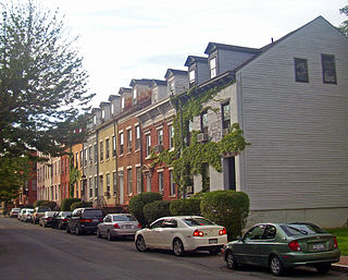
The Mansion Historic District, sometimes referred to as Mansion Hill, is located south of Empire State Plaza in Albany, New York, United States. It takes its name from the nearby New York State Executive Mansion, which overlooks it. It is a 45-acre (18 ha), 16-block area with almost 500 buildings. Many of them are rowhouses and townhouses built in the middle and late 19th century that remain mostly intact today.

There are 75 properties listed on the National Register of Historic Places in Albany, New York, United States. Six are additionally designated as National Historic Landmarks (NHLs), the most of any city in the state after New York City. Another 14 are historic districts, for which 20 of the listings are also contributing properties. Two properties, both buildings, that had been listed in the past but have since been demolished have been delisted; one building that is also no longer extant remains listed.
Kenwood was a hamlet in the Town of Bethlehem, New York. The hamlet spanned both sides of the Normans Kill near the area where the Normans Kill flows into the Hudson River. In 1870, and again in 1910, northern portions of Kenwood were annexed by the City of Albany, New York.
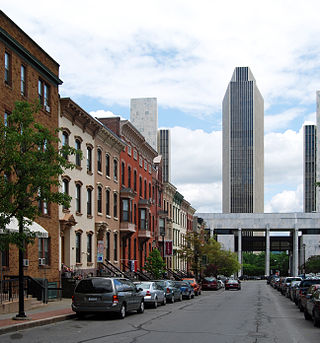
The architecture of Albany, New York, embraces a variety of architectural styles ranging from the early 18th century to the present. The city's roots date from the early 17th century and few buildings survive from that era or from the 18th and early 19th century. The completion of the Erie Canal in 1825 triggered a building boom, which continued until the Great Depression and the suburbanization of the area afterward. This accounts for much of the construction in the city's urban core along the Hudson River. Since then most construction has been largely residential, as the city spread out to its current boundaries, although there have been some large government building complexes in the modernist style, such as Empire State Plaza, which includes the Erastus Corning Tower, the tallest building in New York outside of New York City.

North Albany is a neighborhood in the city of Albany, New York. North Albany was settled in the mid-17th century by the Patroon of Rensselaerswyck and his tenants and later became a hamlet in the town of Watervliet. Due to the Erie Canal being constructed in 1825, North Albany saw immense growth, with the Albany Lumber District and an influx of Irish immigrants lending the area the name of Limerick. Home to many historic warehouses and row houses, North Albany continues to be an important industrial neighborhood. Recent efforts have begun to gentrify the neighborhood by adapting heavy industry/warehouse use to artistic and entertainment venues, such as a German beer garden, an amusement park, live music venues, and arts and crafts marketplaces.

The Arbor Hill Historic District–Ten Broeck Triangle, originally the Ten Broeck Historic District, is a seven-block area located within the Arbor Hill neighborhood north of what is today downtown Albany, New York, United States. In 1979 its easternmost third, the Ten Broeck Triangle, the second oldest residential neighborhood in the city, was recognized as a historic district and listed on the National Register of Historic Places. Four years later, the district was increased to its current size and renamed to reflect its expansion to include some of the rest of Arbor Hill.

The South End–Groesbeckville Historic District is located in part of the neighborhood of that name in Albany, New York, United States. It is a 26-block, 57-acre (23 ha) area south of the Mansion and Pastures neighborhoods with a mix of residential and commercial properties. In 1984 it was recognized as a historic district and listed on the National Register of Historic Places.

The history of Albany, New York from 1860 to 1900 begins in 1860, prior to the start of the Civil War, and ends in 1900.
References
- ↑ Stefan Bielinski (September 10, 2005). "Groesbeck". New York State Museum. Retrieved June 9, 2010.
- 1 2 3 4 Judith Botch and Miriam Trementozzi (2006). "O Albany's South End: A Walking Tour; Pastures, Mansions, and Personalities" (PDF). New York State Writers Institute (State University of New York). Retrieved June 9, 2010.
- ↑ "South End-Groesbeckville Historic District". The Gombach Group. 2010. Retrieved December 3, 2012.
- ↑ Pat Paternak. "Albany parish closing". The Evangelist. Archived from the original on July 22, 2011. Retrieved June 10, 2010.