
Longitude, is a geographic coordinate that specifies the east–west position of a point on the Earth's surface, or the surface of a celestial body. It is an angular measurement, usually expressed in degrees and denoted by the Greek letter lambda (λ). Meridians connect points with the same longitude. By convention, one of these, the Prime Meridian, which passes through the Royal Observatory, Greenwich, England, was allocated the position of 0° longitude. The longitude of other places is measured as the angle east or west from the Prime Meridian, ranging from 0° at the Prime Meridian to +180° eastward and −180° westward. Specifically, it is the angle between a plane through the Prime Meridian and a plane through both poles and the location in question.

Surveying or land surveying is the technique, profession, art and science of determining the terrestrial or three-dimensional positions of points and the distances and angles between them. A land surveying professional is called a land surveyor. These points are usually on the surface of the Earth, and they are often used to establish maps and boundaries for ownership, locations, such as building corners or the surface location of subsurface features, or other purposes required by government or civil law, such as property sales.

A theodolite is a precision optical instrument for measuring angles between designated visible points in the horizontal and vertical planes. The traditional use has been for land surveying, but they are also used extensively for building and infrastructure construction, and some specialized applications such as meteorology and rocket launching.

Magnetic declination, or magnetic variation, is the angle on the horizontal plane between magnetic north and true north. This angle varies depending on position on the Earth's surface and changes over time.
Gromatici or agrimensores was the name for land surveyors amongst the ancient Romans. The "gromatic writers" were technical writers who codified their techniques of surveying.

The term Jacob's staff, also known as cross-staff, a ballastella, a fore-staff, or a balestilha, is used to refer to several things. In its most basic form, a Jacob's staff is a stick or pole with length markings; most staffs are much more complicated than that, and usually contain a number of measurement and stabilization features. The two most frequent uses are:

A level is an optical instrument used to establish or verify points in the same horizontal plane in a process known as levelling, and is used in conjunction with a levelling staff to establish the relative heights levels of objects or marks. It is widely used in surveying and construction to measure height differences and to transfer, measure, and set heights of known objects or marks.

The solar compass, a surveying instrument that makes use of the sun's direction, was first invented and made by William Austin Burt. He patented it on February 25, 1836, in the United States Patent Office as No 9428X. It received a medal at the Great Exhibition of 1851.
A dioptra is a classical astronomical and surveying instrument, dating from the 3rd century BC. The dioptra was a sighting tube or, alternatively, a rod with a sight at both ends, attached to a stand. If fitted with protractors, it could be used to measure angles.
Tacheometry is a system of rapid surveying, by which the horizontal and vertical positions of points on the earth's surface relative to one another are determined without using a chain or tape, or a separate levelling instrument. Instead of the pole formerly employed to mark a point, a staff similar to a level staff is used. This is marked with heights from the base or foot, and is graduated according to the form of tacheometer in use.
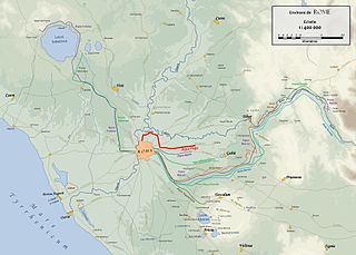
The Aqua Virgo was one of the eleven Roman aqueducts that supplied the city of ancient Rome. The aqueduct fell into disuse with the fall of the Western Roman Empire, but was fully restored nearly a millennium later during the Italian Renaissance to take its current form as the Acqua Vergine. The Aqua Virgo was completed in 19 BC by Marcus Agrippa, during the reign of the emperor Augustus. Its source is just before the 8th milestone north of the Via Collatina, in a marshy area about 3 km from the Via Praenestina. It was also supplemented by several feeder channels along its course. The name is thought to be derived from the purity and clarity of the water because it does not chalk significantly. According to a legend repeated by Frontinus, thirsty Roman soldiers asked a young girl for water who directed them to the springs that later supplied the aqueduct; Aqua Virgo was named after her.

The music of ancient Rome was a part of Roman culture from the earliest of times. Songs (carmen) were an integral part of almost every social occasion. The Secular Ode of Horace, for instance, was commissioned by Augustus and performed by a mixed children's choir at the Secular Games in 17 BC. Music was customary at funerals, and the tibia, a woodwind instrument, was played at sacrifices to ward off ill influences. Under the influence of ancient Greek theory, music was thought to reflect the orderliness of the cosmos, and was associated particularly with mathematics and knowledge.
The Chorobates, described by Vitruvius in Book VII of the Architecture, was used to measure horizontal planes and was especially important in the construction of aqueducts.

A circumferentor, or surveyor's compass, is an instrument used in surveying to measure horizontal angles. It was superseded by the theodolite in the early 19th century.

A measuring rod is a tool used to physically measure lengths and survey areas of various sizes. Most measuring rods are round or square sectioned; however, they can also be flat boards. Some have markings at regular intervals. It is likely that the measuring rod was used before the line, chain or steel tapes used in modern measurement.
Reflecting instruments are those that use mirrors to enhance their ability to make measurements. In particular, the use of mirrors permits one to observe two objects simultaneously while measuring the angular distance between the objects. While reflecting instruments are used in many professions, they are primarily associated with celestial navigation as the need to solve navigation problems, in particular the problem of the longitude, was the primary motivation in their development.
Construction surveying or building surveying is to stake out reference points and markers that will guide the construction of new structures such as roads or buildings. These markers are usually staked out according to a suitable coordinate system selected for the project.
Centuriation, also known as Roman grid, was a method of land measurement used by the Romans. In many cases land divisions based on the survey formed a field system, often referred to in modern times by the same name. According to O. A. W. Dilke, centuriation combined and developed features of land surveying present in Egypt, Etruria, Greek towns and Greek countryside.
Tree height is the vertical distance between the base of the tree and the tip of the highest branch on the tree, and is difficult to measure accurately. It is not the same as the length of the trunk. If a tree is leaning, the trunk length may be greater than the height of the tree. The base of the tree is where the projection of the pith (center) of the tree intersects the existing supporting surface upon which the tree is growing or where the seed sprouted. If the tree is growing on the side of a cliff, the base of the tree is at the point where the pith would intersect the cliff side. Roots extending down from that point would not add to the height of the tree. On a slope this base point is considered as halfway between the ground level at the upper and lower sides of the tree. Tree height can be measured in a number of ways with varying degrees of accuracy.

The Post Plotting Instrument, or simply Post Instrument, was the standard optical sighting system used by the UK's Royal Observer Corps (ROC) to determine the location of aircraft. It was used during the period from the mid-1930s into the early 1950s, and was one of the main sources of daytime tracking information during World War II.
