The Graian Alps are a mountain range in the western part of the Alps.

The Tödi, is a mountain massif and with the mountain peak Piz Russein the highest mountain in the Glarus Alps and the highest summit in the canton of Glarus, Switzerland. It is located on the border between the cantons of Graubünden, to the south, and Glarus, to the north, close to the point where those two cantons meet the canton of Uri, to the west. Although not the culminating point of Graubünden, it is its highest peak outside the Bernina range.

Hautes-Alpes is a department of Provence-Alpes-Côte d'Azur in southeastern France named after the Alps mountain range.

The canton of Valais is one of the 26 cantons of Switzerland, situated in the southwestern part of the country, around the valley of the Rhône from its headwaters to Lake Geneva, separating the Pennine Alps from the Bernese Alps. The canton is simultaneously one of the driest regions of Switzerland in its central Rhône valley and among the wettest, having large amounts of snow and rain up on the highest peaks found in Switzerland. The canton of Valais is widely known for the Matterhorn and resort towns such as Crans-Montana, Saas Fee, Verbier and Zermatt. It is composed of 13 districts and its capital is Sion.
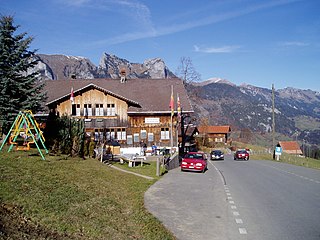
Jaun Pass is a high mountain pass in the Swiss Alps linking Charmey and Jaun in the canton of Fribourg with Reidenbach in the canton of Bern. The pass itself is located within the canton of Berne.
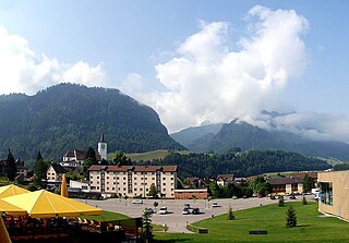
Gruyère is one of seven districts of the canton of Fribourg in Switzerland. It has a population of 54,431. Its capital is Bulle.

Johann Gottfried Steffan was one of the most important Swiss landscapists of the 19th century.

Lac de Montsalvens is a reservoir in the Canton of Fribourg, Switzerland. The reservoir has a capacity of 12.6 million m³ and a surface area of 0.74 km2 (0.29 sq mi). It is located on the road to Jaun Pass, between the villages of Broc and Charmey.

The Muota is a river in the Swiss canton of Schwyz and a tributary of Lake Lucerne. It has a length of 29 km (18 mi).

The Vanil Noir is a mountain of the Fribourg Prealps, located on the border between the cantons of Fribourg and Vaud in western Switzerland. Reaching a height of 2,389 metres above sea level, the Vanil Noir is the highest summit of the canton of Fribourg and of the Alpine foothills lying north of the Saane and Simme. It is also the northernmost point in the canton of Vaud above 2,300 metres and the most prominent summit of both cantons.
The Col Ferret is an Alpine pass between the canton of Valais and the Aosta Valley. This pass separates the Mont Blanc Massif from the Pennine Alps.

The Ringelspitz is a mountain of the Glarus Alps, located on the border between the Swiss cantons of St. Gallen and Graubünden. Reaching a height of 3,248 metres above sea level, it is the highest summit in the canton of St. Gallen. It is split between three municipalities: Pfäfers, Trin and Tamins (Graubünden).

Mont Gelé is a mountain of the Pennine Alps, part of the Municipality Riddes and overlooking Verbier in the Swiss canton of Valais. Located on the range north of Mont Fort, its summit is the tripoint between the municipalities of Bagnes, Riddes and Nendaz. It is one of the two mountains named Mont Gelé in the valley of Bagnes, the other being located on the Italian border.

The Dent de Brenleire is a mountain of the Fribourg Alps, located south of Charmey in the Swiss canton of Fribourg. It has an elevation of 2,353 metres above sea level and is amongst the highest summits in the canton of Fribourg, after the Vanil Noir, the Vanil de l'Ecri and the Pointe de Paray. It is also the highest mountain entirely within the canton.

The Schopfenspitz is a mountain of the Bernese Alps, overlooking Jaun in the canton of Fribourg. It is the culminating point of the group lying between Charmey and the Euschelspass.

The Dent de Savigny is a mountain of the Bernese Alps, located on the border between the Swiss cantons of Vaud and Fribourg. With an elevation of 2,252 metres above sea level, it one of the highest mountains in the canton of Fribourg.

La Balisa is a high mountain pass of the Swiss Alps, connecting Schwarzsee with Charmey via La Valsainte in the canton of Fribourg. The pass lies on the watershed between the Sense and Le Javro. The pass is traversed by a trail.

Mont Risoux is a large wooded crest of the Jura Mountains, located between France and Switzerland. The culminating point, lying on the border between the department of Doubs and the canton of Vaud, is named Gros Crêt.