Related Research Articles

An earthquake – also called a quake, tremor, or temblor – is the shaking of the surface of Earth resulting from a sudden release of energy in the lithosphere that creates seismic waves. Earthquakes can range in intensity, from those that are so weak that they cannot be felt, to those violent enough to propel objects and people into the air, damage critical infrastructure, and wreak destruction across entire cities. The seismic activity of an area is the frequency, type, and size of earthquakes experienced over a particular time. The seismicity at a particular location in the Earth is the average rate of seismic energy release per unit volume. The word tremor is also used for non-earthquake seismic rumbling.
The Modified Mercalli intensity scale measures the effects of an earthquake at a given location. This is in contrast with the seismic magnitude usually reported for an earthquake.

Landslides, also known as landslips, are several forms of mass wasting that may include a wide range of ground movements, such as rockfalls, mudflows, shallow or deep-seated slope failures and debris flows. Landslides occur in a variety of environments, characterized by either steep or gentle slope gradients, from mountain ranges to coastal cliffs or even underwater, in which case they are called submarine landslides.

A natural disaster is the highly harmful impact on a society or community following a natural hazard event. Some examples of natural hazard events include: flooding, drought, earthquake, tropical cyclone, lightning, tsunami, volcanic activity, wildfire. A natural disaster can cause loss of life or damage property, and typically leaves economic damage in its wake. The severity of the damage depends on the affected population's resilience and on the infrastructure available. Scholars have been saying that the term natural disaster is unsuitable and should be abandoned. Instead, the simpler term disaster could be used, while also specifying the category of hazard. A disaster is a result of a natural or human-made hazard impacting a vulnerable community. It is the combination of the hazard along with exposure of a vulnerable society that results in a disaster.

Soil liquefaction occurs when a cohesionless saturated or partially saturated soil substantially loses strength and stiffness in response to an applied stress such as shaking during an earthquake or other sudden change in stress condition, in which material that is ordinarily a solid behaves like a liquid. In soil mechanics, the term "liquefied" was first used by Allen Hazen in reference to the 1918 failure of the Calaveras Dam in California. He described the mechanism of flow liquefaction of the embankment dam as:
If the pressure of the water in the pores is great enough to carry all the load, it will have the effect of holding the particles apart and of producing a condition that is practically equivalent to that of quicksand... the initial movement of some part of the material might result in accumulating pressure, first on one point, and then on another, successively, as the early points of concentration were liquefied.
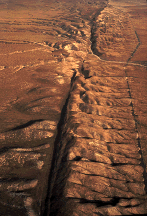
An active fault is a fault that is likely to become the source of another earthquake sometime in the future. Geologists commonly consider faults to be active if there has been movement observed or evidence of seismic activity during the last 10,000 years.
Induced seismicity is typically earthquakes and tremors that are caused by human activity that alters the stresses and strains on Earth's crust. Most induced seismicity is of a low magnitude. A few sites regularly have larger quakes, such as The Geysers geothermal plant in California which averaged two M4 events and 15 M3 events every year from 2004 to 2009. The Human-Induced Earthquake Database (HiQuake) documents all reported cases of induced seismicity proposed on scientific grounds and is the most complete compilation of its kind.
Earthquake engineering is an interdisciplinary branch of engineering that designs and analyzes structures, such as buildings and bridges, with earthquakes in mind. Its overall goal is to make such structures more resistant to earthquakes. An earthquake engineer aims to construct structures that will not be damaged in minor shaking and will avoid serious damage or collapse in a major earthquake. A properly engineered structure does not necessarily have to be extremely strong or expensive. It has to be properly designed to withstand the seismic effects while sustaining an acceptable level of damage.

The Wasatch Fault is an active fault located primarily on the western edge of the Wasatch Mountains in the U.S. states of Utah and Idaho. The fault is about 240 miles long, stretching from southern Idaho, through northern Utah, before terminating in central Utah near the town of Fayette. The fault is made up of ten segments, five of which are considered active. On average the segments are approximately 25 miles long, each of which can independently produce earthquakes as powerful as local magnitude 7.5. The five active segments from north to south are called the Brigham City Fault Segment, the Weber Fault Segment, the Salt Lake City Fault Segment, the Provo Fault Segment and the Nephi Fault Segment.
There have been known various classifications of landslides. Broad definitions include forms of mass movement that narrower definitions exclude. For example, the McGraw-Hill Encyclopedia of Science and Technology distinguishes the following types of landslides:
A landslide dam or barrier lake is the natural damming of a river by some kind of landslide, such as a debris flow, rock avalanche or volcanic eruption. If the damming landslide is caused by an earthquake, it may also be called a quake lake. Some landslide dams are as high as the largest existing artificial dam.

The 2003 Hokkaidō earthquake, scientifically named the 2003 Tokachi-Oki earthquake, occurred off the coast of Hokkaidō, Japan on 26 September at 04:50 local time. At a focal depth of 27 km (17 mi), this great undersea earthquake measured 8.3 on the moment magnitude scale, making it the most powerful earthquake of 2003, as well as one of the most intense earthquakes to hit Japan since modern record-keeping began in 1900.
The 1964 Niigata earthquake struck at 13:01 local time on 16 June with a magnitude of either 7.5 or 7.6. The epicenter was on the continental shelf off the northwest coast of Honshu, Japan, in Niigata Prefecture, about 50 kilometres (31 mi) north of the city of Niigata. The earthquake caused liquefaction over large parts of the city.
A potent magnitude 6.6 Mw intraplate aftershock occurred at 17:16 JST (08:16 UTC) on 11 April, in the Hamadōri region of Fukushima, Japan. With a shallow focus of 13 km (8.1 mi), the earthquake was centred inland about 36 km (22 mi) west of Iwaki, causing widespread strong to locally severe shaking. It was one of many aftershocks to follow the 11 March Tōhoku earthquake, and the strongest to have its epicentre located inland.

Earthquake environmental effects are the effects caused by an earthquake, including surface faulting, tsunamis, soil liquefactions, ground resonance, landslides and ground failure, either directly linked to the earthquake source or provoked by the ground shaking. These are common features produced both in the near and far fields, routinely recorded and surveyed in recent events, very often remembered in historical accounts and preserved in the stratigraphic record. Both surface deformation and faulting and shaking-related geological effects not only leave permanent imprints in the environment, but also dramatically affect human structures. Moreover, underwater fault ruptures and seismically-triggered landslides can generate tsunami waves.
The 1992 Murindó earthquake occurred on October 18 at 15:11 UTC with an epicenter in the Department of Chocó, northern Colombia. The shallow magnitude 7.2 earthquake struck northwest of the town of Murindó, killing ten and injured more than a hundred. Thirty-three municipalities were severely damaged.
The Advanced National Seismic System (ANSS) is a collaboration of the U.S. Geological Survey (USGS) and regional, state, and academic partners that collects and analyzes data on significant earthquakes to provide near real-time information to emergency responders and officials, the news media, and the public. Such information is used to anticipate the likely severity and extent of damage, and to guide decisions on the responses needed.
The 1988 Myanmar–India earthquake, also known as the Indo–Burma earthquake struck the Sagaing Region of Myanmar, about 30 kilometres (19 mi) from the border with India on 6 August at 7:06 am MMT with a moment magnitude (Mw ) of 7.3 or Richter magnitude (ML ) of 7.5. At least five people were killed, more than 30 were injured, and another 30 were missing as a result. Serious damage was reported in India and Bangladesh, while some minor damage occurred in Myanmar. The earthquake was reportedly felt in the Soviet Union.

The 1993 Kushiro–Oki earthquake was one of two large earthquake to strike the Japanese island of Hōkkaido within the same year. The earthquake with a magnitude of 7.6 Mw or 7.8 MJMA struck at 11:06 UTC or 08:06 pm JST on January 15 near the town of Ashoro. Shaking reached a maximum intensity of IX (Violent) on the Mercalli intensity scale, causing considerable damage, and was felt throughout the island, into northern Honshu, Sakhalin, and the Kuril Islands. As a result of the tremors, two people were killed and more than 600 were wounded.
The 1984 Cachar earthquake rattled much of Southern Assam on December 31, 1984, at 5:03 a.m. (UTC+5:30) with an epicenter 20 kilometers southwest of Lakhipur. The quake measured with a magnitude of 6.0 on the moment magnitude scale and an estimated intensity of VIII (Severe) on the Modified Mercalli intensity scale. About 20 people died and 100 others sustained mild to severe injuries.
References
- ↑ "Earthquake Glossary". earthquake.usgs.gov. Retrieved 2021-07-05.
 This article incorporates text from this source, which is in the public domain .
 - ↑ Wartman, Joseph; Rodriguez-Marek, Adrian; Repetto, Pedro C.; Keefer, David K. (2003-01-01). "Ground Failure". Earthquake Spectra. 19 (1_suppl): 35–56. doi:10.1193/1.1737250. ISSN 8755-2930.
- 1 2 "Ground Failure". earthquake.usgs.gov. Retrieved 2021-07-05. This article incorporates text from this source, which is in the public domain .