Related Research Articles

Geelong is a port city in Victoria, Australia, located at the eastern end of Corio Bay and the left bank of Barwon River, about 75 km (47 mi) southwest of Melbourne. With an estimated population of 282,809 in 2023, Geelong is the second largest city in the state of Victoria. It is the administrative centre for the City of Greater Geelong municipality, which is Port Phillip's only regional metropolitan area, and covers all the urban, rural and coastal reserves around the city including the entire Bellarine Peninsula and running from the plains of Lara in the north to the rolling hills of Waurn Ponds to the south, with Corio Bay to the east and the Barrabool Hills to the west.
Footscray railway station is a commuter and regional railway station and the junction point for the Sunbury, Werribee and Williamstown lines and V/Line services to Ballarat, Bendigo and Geelong, part of the Metropolitan and Regional railway networks. It serves the western Melbourne suburb of Footscray in Victoria, Australia. Footscray is a ground level premium station, featuring six platforms, two island platform with two faces and two side platform, connected by an accessible overground concourse. It opened on 17 January 1859, with the current location provided in 1900 and station provided in 2014.

Grovedale is a southern suburb of Geelong, Victoria, Australia. At the 2021 census, Grovedale had a population of 14,869.
Waurn Ponds is a mainly residential southern suburb of Geelong, Victoria, Australia.
Highton is a residential suburb of Geelong, Victoria, Australia. With views across Geelong, Corio Bay and the surrounding region, Highton is located along the banks of the Barwon River and across the rolling Barrabool Hills. The Barwon River straddles Highton to the north and east, while it is bordered by the hilly Ceres and Wandana Heights to the west, the former Kardinia Creek separates the suburb from Belmont to the south-east, and the Princes Highway and Pigdons Road to the south separate the suburb from Waurn Ponds.

Belmont is a southern suburb of Geelong, Victoria, Australia. The name means "beautiful hill". Belmont is geographically separated from the Geelong central business district by the Barwon River. The suburb is primarily residential, with some light industry along Barwon Heads Road. The suburb is part of the City of Greater Geelong local government area. At the 2011 census, Belmont had a population of 13,616.

The Geelong line is a regional passenger rail service operated by V/Line in Victoria, Australia. It serves 15 stations towards its terminus in Waurn Ponds, a southern suburb of Geelong, via the Regional Rail Link. It is the most used regional rail service in Victoria, carrying 8.15 million people in the 2022-23 financial year.

Geelong railway station is a regional railway station on the Warrnambool line, part of the Victorian railway network. It serves the city Geelong, in Victoria, Australia. Geelong station is a ground-level unstaffed station, featuring three platforms, an island platform with two faces and one side platform. It opened on 1 November 1856.

South Geelong railway station is a regional railway station on the Warrnambool line, part of the Victorian railway network. It serves the suburb of South Geelong, in Geelong, Victoria, Australia. South Geelong station is a ground level premium station, featuring two side platforms, connected by an accessible footbridge and concourse. It opened on 1 November 1883 and was rebuilt in 2024 as part of the Regional Rail Revival project.

Corio railway station is a regional railway station on the Warrnambool line, part of the Victorian railway network. It serves the northern Geelong suburb of the same name, in Victoria, Australia. It opened on 15 September 1890, with the current station provided in 1981.

Little River railway station is a regional railway station on the Warrnambool line, part of the Victorian railway network. It serves the town of Little River, in Victoria, Australia. Little River station is a ground level unstaffed station, featuring two side platforms. It opened on 1 January 1857, with the current station provided in 1981.
The Warrnambool line is a long-distance regional rail service in Victoria, Australia. Operated by V/Line, it is the state's fourth longest railway line at 267.3 kilometres (166.1 mi). The line runs from Southern Cross station in central Melbourne to Warrnambool station in the south-west, serving 21 stations via Wyndham Vale, Geelong, Waurn Ponds, and Colac. The line has five return services each weekday and four return services on weekends. Trains on the Warrnambool service run with three- to five-car N-type carriage sets, which are hauled by N class locomotives, and three-car Vlocity units.

Marshall railway station is a regional railway station on the Warrnambool line, part of the Victorian railway network. It serves the southern suburb of Marshall, in Geelong, Victoria, Australia. Marshall station is a ground level premium station, featuring two side platforms, connected by an accessible footbridge and concourse. It opened on 14 July 1879 and was rebuilt in 2024 as part of the Regional Rail Revival project. The station was initially closed on 14 October 1957, then reopened on 26 April 2005.

The Geelong Ring Road is a freeway ring road in Australia beside Geelong's western suburbs from the Princes Freeway at Corio to the Princes Highway at Waurn Ponds. It also connects to the Midland Highway towards Ballarat, and the Hamilton Highway.

Waurn Ponds Shopping Centre is a major regional shopping centre servicing the southern suburbs of the city of Geelong, Victoria, Australia. It is located on the corner of Colac and Pioneer Roads in the suburb of Grovedale.

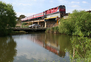
The Warrnambool railway line is a railway serving the south west of Victoria, Australia. Running from the western Melbourne suburb of Newport through the cities of Geelong and Warrnambool, the line once terminated at the coastal town of Port Fairy before being truncated to Dennington. This closed section of line has been converted into the 37 km long Port Fairy to Warrnambool Rail Trail. The line continues to see both passenger and freight services today.
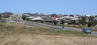
The Armstrong Creek Growth Area is a southern extension to the urban growth boundary of the metropolitan area of Geelong, Victoria, Australia. It comprises parts of the localities of Grovedale and Marshall south of the Warrnambool railway line, and parts of the localities of Mount Duneed and Connewarre from some distance to the north of Lower Duneed Road and generally to the west of Barwon Heads Road.

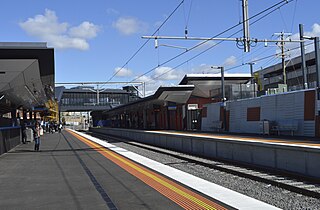
Waurn Ponds railway station is a regional railway station on the Warrnambool line, part of the Victorian railway network. It serves the southern Geelong suburb of Waurn Ponds, in Victoria, Australia. Waurn Ponds station is a ground level premium station, featuring two side platforms. It opened on 12 October 2014, with the current station provided in 2022.
Surfcoast Highway is a semi-rural highway in Victoria, Australia, connecting the city of Geelong with the coastal town of Torquay. The highway runs through the Armstrong Creek Growth Area, which is the subject of extensive residential development; closer to Torquay, tourist attractions the Narana Creations indigenous centre, Surf Coast Plaza retail centre, and the Surfworld museum are located along the highway.
The Regional Rail Revival is a joint initiative between the Australian federal government and the Victorian state government to upgrade all regional railway lines in Victoria. The project has an estimated total cost of A$4 billion. A$2.3 billion of the project's total cost is being funded by the Australian Government. It was delivered by Rail Projects Victoria (RPV) until April 2024, and then by the Level Crossing Removal Project. The project is guided by the 2016 Regional Network Development Plan, which outlines the short, medium and long-term priorities for a modernised regional rail network.
References
- ↑ Rail Geelong - Grovedale Station
- ↑ "Marshalltown road confirmed as site for new station". State Government of Victoria. 16 December 2003. Archived from the original on 25 July 2005.
- ↑ "Marshall - the new station for Geelong". State Government of Victoria. 6 September 2004. Archived from the original on 18 July 2005.
- ↑ "New $26 million Grovedale station a boost for public transport in Geelong". State Government of Victoria. 26 April 2013. Archived from the original on 14 May 2014.
- ↑ Shane Fowles (31 July 2014). "More parking for $25 million Waurn Ponds train station". Geelong Advertiser.