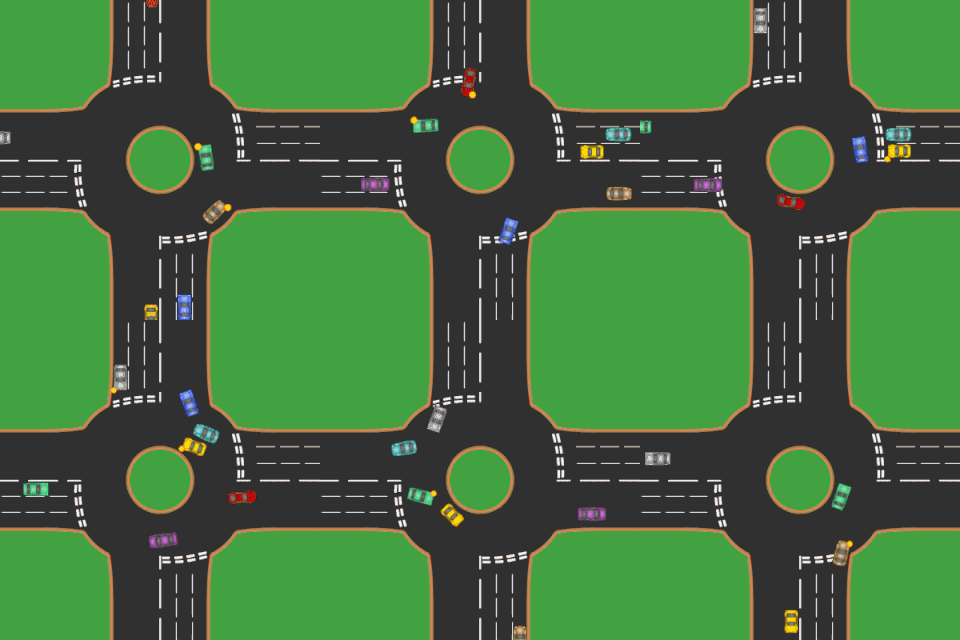
A roundabout, also known as a rotary or traffic circle, is a type of circular intersection or junction in which road traffic is permitted to flow in one direction around a central island, and priority is typically given to traffic already in the junction.

Beverley is a market and minster town and a civil parish in the East Riding of Yorkshire, England, of which it is the county town. The town centre is located 27 miles (43 km) south-east of York and 15 miles (24 km) north-west of Hull.

The East Riding of Yorkshire, often shortened to the East Riding, is a ceremonial county in the Yorkshire and the Humber region of England. It borders North Yorkshire to the north and west, South Yorkshire to the south-west, and Lincolnshire to the south, across the Humber Estuary. The city of Kingston upon Hull is the largest settlement.

The River Hull is a navigable river in the East Riding of Yorkshire in Northern England. It rises from a series of springs to the west of Driffield, and enters the Humber Estuary at Kingston upon Hull. Following a period when the Archbishops of York charged tolls for its use, it became a free navigation. The upper reaches became part of the Driffield Navigation from 1770, after which they were again subject to tolls, and the section within the city of Hull came under the jurisdiction of the Port of Hull, with the same result.

An intersection or an at-grade junction is a junction where two or more roads converge, diverge, meet or cross at the same height, as opposed to an interchange, which uses bridges or tunnels to separate different roads. Major intersections are often delineated by gores and may be classified by road segments, traffic controls and lane design.

Traffic lights, traffic signals, or stoplights – also known as robots in South Africa – are signalling devices positioned at road intersections, pedestrian crossings, and other locations in order to control the flow of traffic.

The A63 is a major road in Yorkshire, England between Leeds and Kingston upon Hull. A section between North Cave and Hull forms the eastward continuation of the M62 motorway and is part of the unsigned Euroroute E20.

Tingley is a suburban village in the City of Leeds in West Yorkshire, Northern England, forming part of the parish of West Ardsley. Tingley forms part of the Heavy Woollen District. It is situated between the cities of Leeds and Wakefield.

The A614 is a main road in England running through the counties of Nottinghamshire, South Yorkshire and the East Riding of Yorkshire.

The A64 is a major road in North and West Yorkshire, England, which links Leeds, York and Scarborough. The A64 starts as the A64(M) ring road motorway in Leeds, then towards York it becomes a high-quality dual carriageway until it is east of York, where it becomes a single carriageway for most of its route to Scarborough.

The M606 is a 3-mile (4.8 km) stretch of motorway in West Yorkshire, England. Called the Bradford Spur motorway, the M606 leaves the M62 motorway at junction 26, near Cleckheaton, and heads into Bradford, to join the A6177 Bradford Ring Road. It is officially named the "Bradford South Radial Motorway" and was opened in 1973.

The A453 road was formerly the main trunk road connecting the English cities of Nottingham and Birmingham. However, the middle section of this mainly single-carriageway road has largely been downgraded to B roads or unclassified roads following the construction of the parallel M42-A42 link around 1990. The M42 was originally meant to pass further north than it does, and to join the M1 at Sandiacre in Derbyshire. The M42/A42 does not enter Derbyshire, but instead joins the M1 closer to the A453 junction at Kegworth. The A42 shadows the former A453 from Appleby Magna to Castle Donington. The road historically connected the East Midlands with the West Midlands.

The A1079 is a major road in Northern England. It links the cities of York and Kingston upon Hull, both in Yorkshire. The road is noted for its past safety issues, and regularly features in the Road Safety Foundations reports on Britain's most dangerous roads. Campaigners have been calling for the entire route to be made into a dual carriageway.

The A629 road is an inter-Yorkshire road that runs from Skipton to Rotherham through Keighley, Halifax, Huddersfield and Chapeltown in Yorkshire, England. The road runs through North, West and South Yorkshire, but before 1974, the entire length of the road was wholly within the boundaries of the West Riding of Yorkshire. It is designated as a primary route through most of its length.

Beverley Beck is a short canal in the East Riding of Yorkshire, England. The beck runs from Grovehill Lock on the River Hull at Beverley west for about 0.8 miles (1.3 km) into the town of Beverley. Until 1802, the beck was tidal, but the Beverley and Barmston Drain needed to pass under it, and the lock was constructed to maintain water levels over its tunnel. In 1898, a steam engine was installed, which could be used to top up the water levels in the beck by pumping water from the River Hull. A multimillion-pound refurbishment of the area concluded in 2007, with the refurbishment of the lock gates and pumping engine.

The York–Beverley line was a railway line between York, Market Weighton and Beverley in Yorkshire, England. The line was sanctioned in 1846 and the first part, the York to Market Weighton Line opened in 1847. Construction of the second part to Beverley was delayed for 17 years in part by the downfall of George Hudson, and a less favourable financial environment following the collapse of the 1840s railway bubble; the North Eastern Railway revived and completed the scheme in the 1860s; the Market Weighton to Beverley Line opened in 1865.

The A1033 road is a main arterial route across Kingston upon Hull and the East Riding of Yorkshire connecting Hull with Withernsea. The road carries traffic to and from the Port of Hull and Salt End at its western end, and local and holiday traffic at its eastern end. It is a primary route from the junction of the A63 road to the Salt End roundabout and is maintained on that section by National Highways. The section by the docks is also part of a designated abnormal load route.

The Harrogate–Church Fenton line was a railway line opened by the York and North Midland Railway between 1847 and 1848 linking Harrogate and Church Fenton.

A protected intersection or protected junction, also known as a Dutch-style junction, is a type of at-grade road junction in which cyclists and pedestrians are separated from cars. The primary aim of junction protection is to make pedestrians and cyclists safer and feel safer at road junctions.

A650 road is a main route through the West Yorkshire conurbation in England. The road goes from Keighley to Wakefield on a rough north west/south east axis for 25 miles (40 km). The route is mostly single carriageway with some dualled sections in the Aire Valley, Bradford and the approach to Wakefield from the M1.


