Mato Grosso is one of the states of Brazil, the third-largest by area, located in the western part of the country.

Torres is a city on the coast of south Brazil in the state of Rio Grande do Sul. The city has a population of approximately 40,000 inhabitants, of which 10,000 live in rural zones, but in summer the number of inhabitants reaches 300,000.
Caverna dos Ecos (GO-018), also called "Gruta dos Ecos", is a mica schist cavern in central Goiás, Brazil. It is located between Cocalzinho de Goiás and Brasília, 134 km from Goiânia. It is near the settlement of Girassol, just after the boundary with the Federal District.

The Grutas de Cacahuamilpa National Park in Guerrero, Mexico, is best known for the Grutas de Cacahuamilpa Caverns, which are one of the largest cave systems in the world. It is also home to the Grutas of Carlos Pacheco, a smaller system, as well as two subterranean rivers which have carved out tunnels in the rock. The park has outdoor pursuit attractions such as rappelling, and rock climbing in Limontitla Canyon. as well as the two underground rivers to explore. It also has a small botanical garden, a pool and places to camp.
Iraquara is a municipality in the state of Bahia in the North-East region of Brazil.
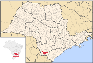
Caverna da Tapagem (SP-002), also Caverna do Diabo, is a cave located within the Jacupiranga State Park next to the Alto Ribeira Tourist State Park, in the municipality of Eldorado Paulista, Iporanga, 280 km from São Paulo, Brazil. It is the second longest cave in the state of São Paulo and also the highlight of what the local guides call "Circuit Disneyland," which is a series of family attractions that people of all ages can enjoy.

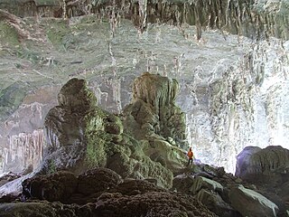
Gruta de Maquiné (MG-0243), also Lapa Nova de Maquiné, is the oldest and one of the most commercially visited caves in Brazil. It is located about 5 km (3.1 mi) from Cordisburgo and 143 km (88.9 mi) northwest of Belo Horizonte, in the State of Minas Gerais. The cave has seven huge chambers explored, amounting to 650 m (2,130 ft) (linear) and unevenness of the ground of only 18 m (59 ft). Safety measures like lighting, walkways and handrails allow a multitude of visitors to enjoy safely the wonders of the grotto where the whole journey is accompanied by an experienced local guide.
Gruta do Padre (BA-052) is a cave located halfway between the municipalities of Santana, Santa Maria da Vitória e Canápolis, in the state of Bahia, Brazil. It is currently the third-longest cave in the country being 16,400 meters long and unevenness of 125 meters. Discovered in 1914 by a priest who sought honey in hives that get stuck in the rocks, it was often a place of religious pilgrimage where the locals came to pay their promises until the 1950s.
Gruta das Areias is a complex of caverns located in the region of Lajeado, in the municipality of Iporanga, São Paulo, Brazil. It is therefore part of the Areias System, located in the southwestern part of the carbonatic area Lajeado-Bombas, on the right bank of the Betari river, in the municipality of Iporanga, southeast of the state. It comprises the caves Ressurgência das Areias (SP-016), the 5.565 meter-long cave Areias de Cima (SP-018) and the Areias de Baixo (SP-019) cave, also popularly called Areias I and II. It is also part of the so-called Açungui group of caverns formed between the Mesoproterozoic and Neoproterozoic, between 1.6 billion and 542 million years ago.
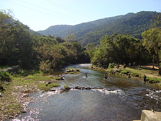
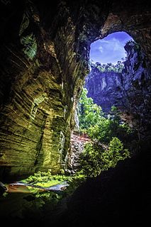
Gruta Casa de Pedra (SP-009) is a cave located in the karstic region of the Alto Ribeira Tourist State Park, between the municipalities of Apiaí and Iporanga, to the south of the State of Sao Paulo, Brazil. It is 2,930 meters long and features the largest cave mouth in the world, measuring 172 meters high. It is located in the final portion of the hydrographic sub-basin of the Maximiano stream which enters the cave for about 800 meters and flows into the Iporanga River. Its name derives from the size of its portico, recognized as the world's largest.
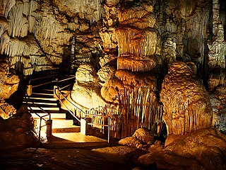
Caverna de Santana (SP-041), also Caverna de Sant'Anna, is a cave located inside the Alto Ribeira Tourist State Park, along the road connecting the towns of Apiaí and Iporanga, to the south of the State of Sao Paulo, Brazil. The Flowers' Hall, displaying thousands of flowers of aragonite, and the Taqueupa Hall as one of the many other formations of great scenic beauty found in the cave, are ranked among the most beautiful and ornated of the world.
Gruta do Centenário (MG-1081), is a cave located in the municipality of Mariana, in the state of Minas Gerais, Brazil. It is the largest and deepest quartzite cave in the world, and second in the country in terms of unevenness. Other caves which are part of the same system have now been partially explored.
Gruta do Janelão (MG-199) is a limestone cave located inside the Cavernas do Peruaçu National Park, in the municipality of Januária, Minas Gerais, Brazil. This cave is the largest in the valley, totaling 4,740 m of horizontal extension and elevation of 176m. Because it has several skylights letting the sun in, small forests that resemble Japanese gardens by the delicacy and harmony are formed everywhere, all by the banks of the Peruaçu River which runs through the Janelão grotto. It has the largest stalactite already registered measuring 28 meters long.
Abismo Ouro Grosso (SP-054), also Gruta Ouro Grosso, is a 192-metre-deep (630 ft) shaft consisting of waterfalls and natural pools. It was created by the capture of surface rivers by carbonate rocks with subterranean drainage systems in an advanced stage of evolution. First explored by the German naturalist and spelunker Michel Le Bret in the 1970s, it is located at the Nucleo Ouro Grosso, within the borders of the Alto Ribeira Tourist State Park, in the municipality of Iporanga, 350 kilometres (220 mi) from Sao Paulo, Brazil.
Gruta da Morena (MG-0270) is a limestone cave, considered the third largest cave in Minas Gerais, 15 km from Cordisburgo, Brazil. Reaching 4620 meters long, it presents five entrances, various halls and a stream. It is close to the road of Povoado do Onça, 6 km from the city. To get to the cave, it is first necessary to go through a track. This specific cave has been very recently included in the area of influence of Gruta de Maquiné, once a new species of arachnid has also been found inside the cave, being it the third troglobitic species of Brazilian Palpigradi found in this cave and of characteristic very similar to the previous species Eukoenenia maquinenses.

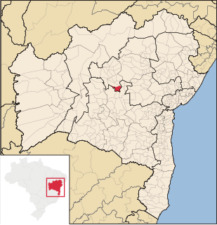
Conjunto Santa Rita is a complex of limestone caves located in the municipality of Iraquara, Bahia, Brazil. It is 17,050 metres (55,940 ft) long and the target of traditional pilgrimage. It contains numerous offerings on the altar and inside. The cave has two large parallel galleries joined by a smaller gallery being both associated with a lower slope. About 600 m have been mapped. The highlight of the cave is a spectacular calcite run-off resembling curtains of over 12 m tall, besides beautiful stratigraphic features on the walls. The small and adjacent Gruta Santa Rita II, has also been quickly mapped.
Areado Grande is the name given to a group of limestone caves located inside the Alto Ribeira Tourist State Park, in the municipality of Iporanga, State of Sao Paulo, Brazil. It consists of Areado Grande I (SP-077), Areado Grande II (SP-078) being 3400 meters long, Areado Grande III (SP-510) with 6004 linear meters, Areado Grande IV (SP-524), Areado Grande V (SP-525). Other caves in the region of the Areado Grande creek are Toca da Pedra Inclinada, Gruta do Toboga, Gruta do Jeep (SP-086), Gruta da Fenda (SP-087), Gruta do Baixao (SP-088), and Gruta da Cabana (SP-108).
Gruta Olhos d'Água (MG-0288) is a 9,100 meter-long cave located in the municipality of Itacarambi, State of Minas Gerais, Brazil. It is considered the fourth longest in Brazil and contains many limestone formations reaching up to 1 km long. The cave is 1180 m wide in its main axis and is formed by rocks of the pre-cambrian age, belonging to the Açungui Group of caverns frequently used for extraction of marble, limestone, talc, lead and iron. Its fauna consists of bats and spiders as well as depigmented crickets.
Gruta Canabrava (BA-0261) is a limestone cave measuring 5,500 metres (18,000 ft) long, located near the municipality of Santana, in the State of Bahia, Brazil.