
Gamle Oslo is a district of the city of Oslo, Norway. The name means "Old Oslo".
Greater Oslo Region is a statistical metropolitan region surrounding the Norwegian capital of Oslo. The region includes the city of Oslo, the entire county of Akershus and several municipalities in the counties of Buskerud (150,709), Oppland (8,552), Vestfold (27,695) and Østfold (102,808).

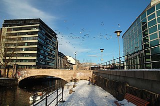
Akerselva or Akerselven is a river which flows through Oslo. It starts at Maridalsvannet in Oslomarka, and follows the urban areas Nordre Aker, Sagene, Grünerløkka, Oslo centre and Grønland, whereby it finally ends at Paulsenkaien and Oset in Bjørvika. The river is considered to be a part of the Nordmarkvassdraget, and has the watercourse number 006.Z. The entire river is about 8.2 kilometres (5.1 mi) long, and has a difference in elevation between source and mouth of approximately 149 metres (489 ft).
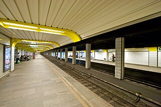
Grønland is a rapid transit station on the Oslo Metro in the Common Tunnel serving all six lines. It is located in the business and residential area Grønland, between the stations Jernbanetorget to the west and Tøyen to the east. The station was opened on 22 May 1966 with the opening of the subway, and underwent refurbishments 1988–92. Peer Qvam was the original architect.

The National Theatre in Oslo is one of Norway's largest and most prominent venues for performance of dramatic arts.
Voldsløkka Stadion is a football stadium in Oslo, Norway. Its visitor capacity is 4,000.

Sørengautstikkeren is a neighborhood in the borough Gamle Oslo in Oslo, Norway. It is an artificial peninsula that sticks out into the Oslofjord form Bjørvika and Sørenga. It is part of the Port of Oslo, but will be redeveloped as part of the Fjord City urban redevelopment program, after the Bjørvika Tunnel is completed in 2010, and the European Route E18 will run under the area. Until then, it is used as a container port, a quay for cruiseships and as a storage area for earth and bulk. The quay is 880 metres (2,890 ft) long.

The Fjord City is an urban renewal project for the waterfront part of the center of Oslo, Norway. The first redevelopment was at Aker Brygge during the 1980s. Bjørvika and Tjuvholmen followed up during the 2000s, while the remaining parts of the Port of Oslo will be developed in the 2010s. The port will be relocated to Sørhavna. The planning is performed by the Oslo Waterfront Planning Office. Major investments in the area include a new Central Railway Station, an already completed Oslo Opera House, and the commercial buildings in the Barcode Project. Several large cultural institutions will be moved to Bjørvika, including moving the Oseberg Ship, Oslo Public Library, and the Munch Museum. The main barrier between the city and the fjord will disappear when European Route E18 is relocated to the Bjørvika Tunnel.
Apoteket Hjorten was a pharmacy located at Grønland in Oslo, Norway. The name "Apoteket Hjorten" is used for a number of pharmacies in several Norwegian cities such as Fredrikstad and Trondheim. The pharmacy is now renamed to Vitusapotek Hjorten, and the modern building is located in Smalgangen 5.

Asylet is the popular name of a building located at Grønland 28 in Oslo, Norway.
Vaterland Bridge is a bridge that crosses the Aker River in the city center of Oslo, Norway.

Olaf Ryes plass is a square and park placed centrally in the Grünerløkka borough of Oslo, Norway. It is more or less square in shape.

Schous plass is a square in the southern part of the borough of Grünerløkka in Oslo, Norway.

The 1943 Filipstad explosion was a fire in an ammunition store at Filipstad in Oslo on Sunday, 19 December 1943, during the occupation of Norway by Nazi Germany. The fire started during the unloading of ammunition from the transport ship Selma. The estimated amount of exploded ammunition varies from 800 to 1,200 tons. A large number of shells and grenades were tossed into the air and spread over the city. There were around 40 Norwegian casualties and around 75 Germans were killed, and 400 wounded. About 400 buildings were severely damaged.
Stortorvet is a station on the Oslo Tramway in Oslo, Norway. The station is located on the square Stortorvet in the city centre. It is served by the lines 11, 17 and 18. In 2009, it was decided to improve the square, the station and the tram tracks in the street.
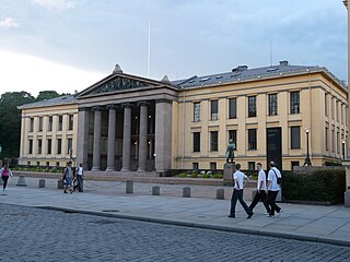
Universitetsplassen is a square in the city center of Oslo, Norway. The square borders the street Karl Johans gate, and is surrounded by three buildings of the Faculty of Law, University of Oslo.

Ormøya is an inhabited island in the inner part of Oslofjord, in the municipality of Oslo. It is located north of the island Malmøya and west of the mainland at Bekkelaget / Nordstrand. A bridge over the strait Ormsundet connects the island to the mainland. The island covers an area of 0.18 square kilometres (0.069 sq mi) Ormøy Church, designed by architect Bernhard Steckmest, was built in the 1890s. On the island there are beaches, boating ports and a small park.

Enerhaugen is today a neighborhood in Oslo, Norway which among others includes six apartment buildings on Toyen in the borough of Gamle Oslo, located north of the neighborhood of Grønland. The site is located on a hill just south of Tøyen manor, and was largely undeveloped in the first half of the 1800s, where it then became a sort of suburb of Oslo. The streets of today's Enerhaugen is Sørligata, Enerhaugggata and Smedgata. The closest subway station is Tøyen.
The Intercultural Museum in Oslo, Norway, was founded in 1990 by Bente Guro Møller. It is located at Tøyenbekken 5, in an old police station in the district of Grønland at the eastern side of downtown Oslo. The Intercultural Museum is a migration museum, and is primarily concerned with the collection, preservation and dissemination of Norwegian immigration history.


