Spain is a country located in southwestern Europe occupying most of the Iberian Peninsula. It also includes a small exclave inside France called Llívia, as well as the Balearic Islands in the Mediterranean, the Canary Islands in the Atlantic Ocean 108 km (67 mi) off northwest Africa, and five places of sovereignty on and off the coast of North Africa: Ceuta, Melilla, Islas Chafarinas, Peñón de Alhucemas, and Peñón de Vélez de la Gomera.

The Tagus is the longest river in the Iberian Peninsula. The river rises in the Montes Universales near Teruel, in mid-eastern Spain, flows 1,007 km (626 mi), generally westward, and empties into the Atlantic Ocean in Lisbon.

The Feather River is the principal tributary of the Sacramento River, in the Sacramento Valley of Northern California. The river's main stem is about 73 miles (117 km) long. Its length to its most distant headwater tributary is just over 210 miles (340 km). The main stem Feather River begins in Lake Oroville, where its four long tributary forks join—the South Fork, Middle Fork, North Fork, and West Branch Feather Rivers. These and other tributaries drain part of the northern Sierra Nevada, and the extreme southern Cascades, as well as a small portion of the Sacramento Valley. The total drainage basin is about 6,200 square miles (16,000 km2), with approximately 3,604 square miles (9,330 km2) above Lake Oroville.

Segura is a medium-sized river in southeastern Spain. It has its source in the Sierra de Segura.

The Omo River in southern Ethiopia is the largest Ethiopian river outside the Nile Basin. Its course is entirely contained within the boundaries of Ethiopia, and it empties into Lake Turkana on the border with Kenya. The river is the principal stream of an endorheic drainage basin, the Turkana Basin.

The geography of the U.S. State of Colorado is diverse, encompassing both rugged mountainous terrain, vast plains, desert lands, desert canyons, and mesas. Colorado is a landlocked U.S. state. In 1861, the United States Congress defined the boundaries of the new Territory of Colorado exclusively by lines of latitude and longitude, stretching from 37°N to 41°N latitude, and from 102°02'48"W to 109°02'48"W longitude. Starting in 1868, official surveys demarcated the boundaries, deviating from the parallels and meridians in several places. Later surveys attempted to correct some of these mistakes but in 1925 the U.S. Supreme Court affirmed that the earlier demarcation was the official boundary. The borders of Colorado are now officially defined by 697 boundary markers connected by straight boundary lines. Colorado, Wyoming, and Utah are the only states that have their borders defined solely by straight boundary lines with no natural features. The southwest corner of Colorado is the Four Corners Monument at 36°59'56"N, 109°2'43"W. This is the only place in the United States where four states meet: Colorado, New Mexico, Arizona, and Utah.
The Central Valley, Intermediate Depression, or Longitudinal Valley is the depression between the Chilean Coastal Range and the Andes Mountains. The Chilean Central Valley extends from the border with Peru to Puerto Montt in southern Chile, with a notable interruption at Norte Chico. South of Puerto Montt the valley has a continuation as a series of marine basins up to the isthmus of Ofqui. Some of Chile's most populous cities lie within the valley including Santiago, Temuco, Rancagua, Talca and Chillán.
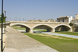
Coy is a town within the municipality of Lorca, in the Spanish province of Murcia. It has a population of 511 and is located 22 miles north of Lorca. Previously known for their supply of metals, they are now known for their wine and traditional crafts.

The Genil River is the main (left) tributary of the river Guadalquivir in Andalusia, Spain. The Roman Singilis, its modern name derives from the Moorish rendering of the Roman name: Sinyil, Sannil, and Sinnil.

Kanab Creek is one of the many tributaries of the Colorado River. It begins in Kane County, Utah, just south of the watershed to the Great Basin and flows 125 miles (201 km) south to the Colorado River.

Brickfields Meadow is a meadow in Woodside in the London Borough of Croydon. It is located on the former site of a brickworks in Tennison Road and Dickensons Lane. The meadow covers an area of about 4.37 hectares. The meadow is not very well known to residents on Tennison Road, as the entrance is very secluded, beyond an EDF Energy transformer. The meadow includes: large pond where fishing is allowed, dipping platform, Buddleia Valley, grassland and woodland planting, small woodland area, and a children's play area which includes a mini maze and roundabout.

Little Yosemite Valley is a smaller glacial valley upstream in the Merced River drainage from the Yosemite Valley in Yosemite National Park. The Merced River meanders through the 3.5 mi (5.6 km) long flat valley, draining out over Nevada Fall and Vernal Fall before emptying into the main Yosemite Valley. It can be reached by a day hike from the main valley, and is the most popular area in the Yosemite Wilderness. The Valley provides access to nearby destinations such as the back side of Half Dome, Clouds Rest and the High Sierra Camp at Merced Lake.

The Temecula Valley is a graben rift valley in western Riverside County, California.

Wakhan River ; known locally as Ab-i-Wakhan or Abe Vâxân, Вахондарё and Vaxondaryo) is the name of the Sarhadd branch of the Panj River along its upper length in the Wakhan District of Badakhshan province of Afghanistan.
The Baetic Depression is an alluvial plain in the lower valley of the Guadalquivir in Andalusia, Spain.

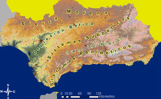
The Intrabaetic Basin is a discontinuous series of valleys in the Baetic System of Andalusia, Spain.
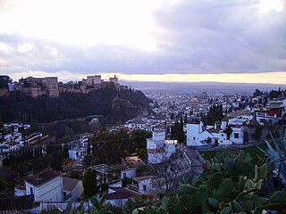
The Granada Basin, Depression of Granada or Granada Depression is a totally enclosed valley in Andalusia, Spain. The river Genil runs through the valley upon exiting from the Sierra Nevada until it passes through the Infiernos de Loja. On the north it borders the comarca of Los Montes on the southern border of the Cordillera Subbética; on the north west are the Sierra de Loja and El Hacho; on the southwest the Sierra Gorda; in the south the Sierra de la Almijara; and in the east the aforementioned Sierra Nevada. It is one of the series of valleys forming the Surco Intrabético.
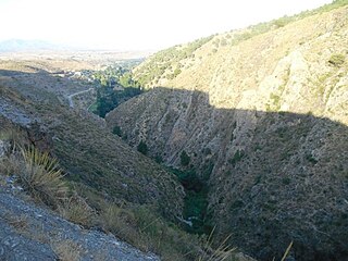
The Almanzora River is a river in the province of Almería in Andalusia, Spain.

The Balsas River is a major river of south-central Mexico.
There is not consensus and agreement in the demarcation of the comarcas of the region and some of them varies largely depending on the comarcas proposal. According to La Verdad newspapers’ Region of Murcia Atlas, there are three main divisions corresponding to three different authors.