Related Research Articles

São Carlos is a Brazilian municipality in the interior of the state of São Paulo, 254 kilometers from the city of São Paulo. With a population of 254,484 inhabitants, it is the 13th largest city in the state in terms of the number of residents, being almost in the center of the state of São Paulo. The municipality is formed by the headquarters and the districts of Água Vermelha, Bela Vista São-Carlense, Santa Eudóxia and Vila Nery.

São Paulo is one of the 26 states of the Federative Republic of Brazil and is named after Saint Paul of Tarsus. A major industrial complex, the state has 21.9% of the Brazilian population and is responsible for 33.9% of Brazil's GDP. São Paulo also has the second-highest Human Development Index (HDI) and GDP per capita, the fourth-lowest infant mortality rate, the third-highest life expectancy, and the third-lowest rate of illiteracy among the federative units of Brazil. São Paulo alone is wealthier than Argentina, Uruguay, Paraguay, and Bolivia combined. São Paulo is also the world's twenty-eighth-most populous sub-national entity and the most populous sub-national entity in the Americas.
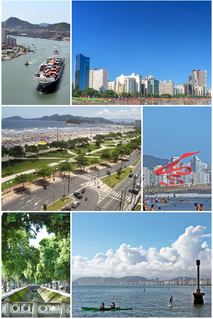
Santos is a municipality in the Brazilian state of São Paulo, founded in 1546 by the Portuguese nobleman Brás Cubas. It is located mostly on the island of São Vicente, which harbors both the city of Santos and the city of São Vicente, and partially on the mainland. It is the main city in the metropolitan region of Baixada Santista. The population is 433,656 in an area of 280.67 km2 (108.37 sq mi). The city is also home to the Coffee Museum, where world coffee prices were once negotiated. There is also a football memorial, dedicated to the city's greatest players, which includes Pelé, who spent the majority of his career with Santos Futebol Clube. Its beachfront garden, 5,335 m (5,834 yd) in length, figures in the Guinness Book of Records as the largest beachfront garden in the world.

São Paulo is a municipality in the Southeast Region of Brazil. The metropolis is an alpha global city and the most populous city in Brazil, the Americas, the Western Hemisphere and the Southern Hemisphere. Additionally, São Paulo is the largest Portuguese-speaking city in the world. The municipality is also the world's 4th largest city proper by population. The city is the capital of the surrounding state of São Paulo, the most populous and wealthiest state in Brazil. It exerts strong international influences in commerce, finance, arts and entertainment. The name of the city honors the Apostle, Saint Paul of Tarsus. The city's metropolitan area, the Greater São Paulo, ranks as the most populous in Brazil and the 12th most populous on Earth. The process of conurbation between the metropolitan areas located around the Greater São Paulo created the São Paulo Macrometropolis, a megalopolis with more than 30 million inhabitants, one of the most populous urban agglomerations in the world.

The São Francisco River or Rio São Francisco is a river in Brazil. With a length of 2,914 kilometres (1,811 mi), it is the longest river that runs entirely in Brazilian territory, and the fourth longest in South America and overall in Brazil. It used to be known as the Opara by the indigenous people before colonisation, and is today also known as Velho Chico.

São Vicente is a coastal municipality at southern São Paulo, Brazil. It is part of the Metropolitan Region of Baixada Santista. The population is 368,355 in an area of 147.89 square kilometres.

Bauru is a Brazilian municipality in midwestern region of the state of São Paulo. It is the main city of the mesoregion and microregion of Bauru. The population is 379,297 in an area of 667.68 km². Established in 1896, its boundaries are Reginópolis to the north, Arealva to the northeast, Pederneiras to the east, Agudos and Piratininga to the south and Avaí to the west.

Guarulhos is a Brazilian municipality. It is the second most populous city in the Brazilian state of São Paulo, the 13th most populous city in Brazil, and is also the most populous city in the country that is not a state capital. In the last few years it has outgrown Campinas. It is part of the Metropolitan Region of São Paulo. The population is 1,392,121 in an area of 318.68 km2. It is the most populous non-capital city in the country and has the second-largest GDP in the state, the 8th largest in the country.

Mogi Guaçu is a municipality in the state of São Paulo in Brazil. The population is 153,033 in an area of 813 km2 (314 sq mi). The city is at an average elevation of 591 m (1,939 ft) above sea level. Mogi Guaçu is a place name that probably originates from the Tupi language. It means "large river of snakes". The city was founded on April 9, 1877.
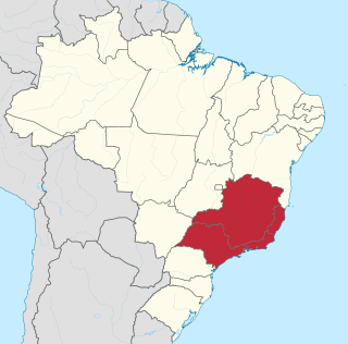
The Southeast Region of Brazil is composed of the states of Espírito Santo, Minas Gerais, Rio de Janeiro and São Paulo. It is the richest region of the country, responsible for approximately 60% of the Brazilian GDP, as São Paulo, Rio de Janeiro, and Minas Gerais are the three richest states of Brazil, the top three Brazilian states in terms of GDP. The Southeast of Brazil also has the highest GDP per capita among all Brazilian regions.

São Caetano do Sul is a city in São Paulo state in Brazil. It is part of the Metropolitan Region of São Paulo. The population is 161,957 in an area of 15.33 km2. It is the city with the highest per capita income in Brazil and it also has the highest Human Development Index.

The Tietê River is a Brazilian river in the state of São Paulo.

Rodovia Marechal Cândido Rondon is a highway in the state of São Paulo, Brazil.

Rodovia Ayrton Senna da Silva, is a highway in the state of São Paulo, Brazil.
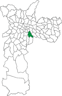
Ipiranga is an historical district located in the subprefecture of the same name of São Paulo, Brazil. The name Ipiranga comes from the river of the same name located in the region, which means "red river" in a Tupí–Guaraní language. The Independence Park, where supposedly the Emperor Pedro I of Brazil proclaimed the independence of Brazil, the Paulista Museum, which exhibits classic architecture and a collection of Brazilian colonial artifacts, and the Museum of Zoology of the University of São Paulo, are also located in Ipiranga.

The Rodovia Presidente Dutra,, colloquially known as Via Dutra is a federal highway which runs through the eastern part of the state of São Paulo and southwestern region of the state of Rio de Janeiro. It is the part of the route BR-116 connecting the city of São Paulo to the city of Rio de Janeiro.

The coastline of Brazil measures 7,491 km, which makes it the 16th longest national coastline of the world. All the coast lies adjacent to the Atlantic Ocean.

The Ipiranga Brook, is a river of São Paulo state in southeastern Brazil, historically known as the place where Dom Pedro I declared the independence of Brazil from the United Kingdom of Portugal, Brazil and the Algarves.
Português macarrônico is an Italian-Portuguese macaronic language that was widely spoken by Italian immigrants in Brazil well into the 1950s and early 1960s.
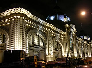
The Municipal Market of São Paulo is a large public market in São Paulo, Brazil. It was designed by the architect Francisco Ramos de Azevedo and inaugurated on January 25, 1933 as a wholesale and retail post specializing in fruits, vegetables, cereals, meats, spices and other food products. The market is located in the Mercado neighborhood, a name that references the market, in the historic center of São Paulo. It is located near the Tamanduateí River in the old Várzea do Carmo, a floodplain of the river now primarily used as Dom Pedro II Park. The market was formally named the Mercado Municipal São Paulo in 1995. It is commonly known in São Paulo as the Mercadão, or "big market", and a noted meeting point for resident São Paulo and one of the most visited tourist spots in the city.