
Nahan is a town in Himachal Pradesh in India and is the headquarters of the Sirmaur District. It was the capital of the former Sirmur princely state. Nahan is also known as the "town of ponds".
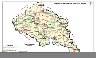
Shahapur is a city and taluka headquarter located in the Yadgir district of Indian state of Karnataka. Shahapur is 597 km north of Bangalore and well connected by road to Gulbarga (70 km), Hyderabad (240 km), Bidar (160 km), Raichur (90 km) and Yadgir (32 km).
Maihar is a city in the Maihar district of the Indian state of Madhya Pradesh. It's Administrative Headquarter of Maihar District. Maihar is known for the Maa Sharda Mandir situated in the city. It is one of the Shakti Peeth.

Raisen is a town and a municipality in Raisen district in the Indian state of Madhya Pradesh. It is the administrative headquarters of Raisen District.

Devanahalli, also called "Devandahalli", "Dyaavandalli", Devanadoddi, and Devanapura, is a town and Town Municipal Council in Bengaluru Rural district in the state of Karnataka in India. The town is located 40 kilometres (25 mi) to the north-east of Bengaluru. Devanahalli is the site of Kempegowda International Airport. A multibillion-dollar Devanahalli Business Park with two IT Parks are coming up on nearly 400 acres (1.6 km2) adjoining the airport. An Aerospace Park, Science Park and a ₹10 billion (US$120 million) Financial City are also coming up. A new satellite ring road will connect the city with Doddaballapur. Devanahalli is situated near the upcoming ₹1,500 billion (US$18 billion), 12,000-acre (49 km2) BIAL IT Investment Region, to be the largest IT region in India.
Chikkaballapur is the district headquarters of the newly created Chikkaballapur district in the state of Karnataka, India, which was carved out from Kolar district. It is located within 3 km of Muddenahalli. A $400 million Pharmaceutical SEZ is coming up in Chikkaballapur on 325 acres (1.32 km2), the first of its kind in India. Furthermore, the noted Traveler Bunglow is being converted into a state-of-the-art bus terminus. A new district government headquarters and police headquarters is being constructed at a cost of $5 million. In addition, the state government is releasing over $10 million to develop the city and expand underground sanitary systems. It is a regional transport and educational hub, and is a major site for grape, grain, and silk cultivation"

Bijoliya is a census town in Bhilwara district in the state of Rajasthan, India and is surrounded by nature and waterfalls and is famous for Tapodaya Teerth Kshetra and Mandakini Temple.
Bhalki is a town in Bidar district in the Indian state of Karnataka.It is 30 km from Bidar.It is the headquarters of Bhalki taluka panchayat.It is well connected by roadways and railways The karanja river one of the main river of Bidar district flows through bhalki taluka.
Chandameta-Butaria is a town and a nagar panchayat in Chhindwara district in the state of Madhya Pradesh, India.

Gajendragad is a Town Municipal Council city in Gadag District, Karnataka, India with Population of 32,359 as of 2011 Census data and is located at 15.73°N 75.98°E. It has an average elevation of 643 metres (2109 feet). This place is known for its hill station,hill strip, film shooting spots, Fort, kalakaleshwara temple, Market for Javali / Dress Materials for marriage & festivals, windmills, Handloom. It is about 55 kilometers from the district head quarter Gadag, 110 kilometers from Hubli, 200 kilometers from Belgaum and 450 kilometers from state capital Bangalore
Kalugumalai is a panchayat town in Kovilpatti Taluk of Thoothukudi district in the Indian state of Tamil Nadu. Kalugumalai is 21 km and 22 km from Kovilpatti and Sankarankovil respectively. The place houses the rockcut Kalugasalamoorthy Temple, monolithic Vettuvan Koil and Kalugumalai Jain Beds.
Kunigal is a town in Tumakuru district in the Indian state of Karnataka. It is the headquarters of Kunigal taluk. As of 2011 census, the town has a population of 34155.
Minjur is a suburb located in the northern outskirts of Chennai, India. It is located in Thiruvallur district in the Indian state of Tamil Nadu. Minjur is called 'Vada Kanchi' meaning North Kanchipuram. The locality has two famous temples for Shiva and Vishnu, similar to Kanchipuram. The neighbourhood is served by Minjur railway station of the Chennai Suburban Railway Network.
Molakalmuru is a taluk in Chitradurga district in the Indian state of Karnataka. It is near the border of Karnataka and Andhra Pradesh. It borders the Rayadurg taluk of Ananthpur district of Andhra Pradesh. Legend has it that its name means "broken knees" in Kannada, referencing a battle between the native Indians and the British in which, due to the rocky and hilly terrain, British soldiers suffered many broken knees in their defeat. The town is famous for the unique Molkalmuru sarees manufactured here.
Nilagiri is a town and a Notified Area Council in Balasore district in the Indian state of Odisha.

Tosham is a town and a Gram Panchayat on the foot of Tosham Hill range in Bhiwani district in the Indian state of Haryana. It has been awarded the title of "Adarsh Village". It is situated in the foothill of Tosham hill range of Aravali Mountain Range. The hill has several historic places, such as forts, carvings, paintings, temples, sacred ponds, dating as far back 1800 years. It is a rural area.
Madakasira is a town with a population 19,432 in 2001 and also a mandal in Sri Satya Sai district in the state of Andhra Pradesh in India. It is located near the state border with Karnataka. The Madakasira Hill Fort in the town is a centrally protected monument of national importance.

Chikkaballapura district is a district in the state of Karnataka, India. On 23 August 2007, it was carved out of the pre-existing Kolar district which was the fourth largest district of Karnataka by moving the talukas of Gauribidanur, Gudibanda, Bagepalli, Chikballapur, Manchenahalli, Chelur, Sidlaghatta and Chintamani into the new district. Kannada is the official language.

Tilothu, also spelled Tilauthu or Tilothu, is a village and corresponding community development block in Rohtas district, Bihar, India. It is located 15 km from Dehri-on-Sone on the west bank of the Son River. As of 2011, the population of Tilouthu was 16,402, in 2,745 families, while the corresponding block population was 109,249.

Kapal Mochan is an ancient place of pilgrimage for both Hindus and Sikhs, 17 km north-east of Yamunanagar city-Jagadhari town, on the Bilaspur road in Yamunanagar district, Haryana, India. It is also called Gopal Mochan and Somsar Mochan. As per Legend, Brāhmanahatya i.e. killing of Brahmin is considered as a major sin, but one who kills a Brahmin and bath here, his Brāhmanahatya sins will be washed. Nearby Bilaspur, Haryana in Yamuna Nagar District which takes its name from the corrupted form of "Vyas Puri", was the ashram of Ved Vyasa rishi where he wrote the Mahabharta on the banks of Sarasvati river near Adi Badri where Sarasvati river leaves Himalayas and enters the plains.


