Related Research Articles

Cartography is the study and practice of making and using maps. Combining science, aesthetics and technique, cartography builds on the premise that reality can be modeled in ways that communicate spatial information effectively.
An atlas is a collection of maps; it is typically a bundle of maps of Earth or of a region of Earth.

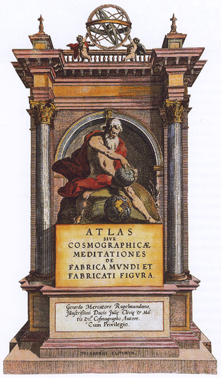
Gerardus Mercator was a Flemish geographer, cosmographer and cartographer. He is most renowned for creating the 1569 world map based on a new projection which represented sailing courses of constant bearing as straight lines—an innovation that is still employed in nautical charts.

Abraham Ortelius was a Brabantian cartographer, geographer, and cosmographer. He is recognized as the creator of the first modern atlas, the Theatrum Orbis Terrarum. Along with Gemma Frisius and Gerardus Mercator, Ortelius is generally considered one of the founders of the Netherlandish school of cartography and geography. He was a notable figure of this school in its golden age and an important geographer of Spain during the age of discovery. The publication of his atlas in 1570 is often considered as the official beginning of the Golden Age of Netherlandish cartography. He was the first person proposing that the continents were joined before drifting to their present positions.
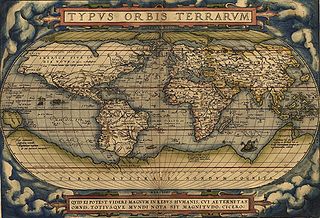
Theatrum Orbis Terrarum is considered to be the first true modern atlas. Written by Abraham Ortelius, strongly encouraged by Gillis Hooftman and originally printed on 20 May 1570 in Antwerp, it consisted of a collection of uniform map sheets and supporting text bound to form a book for which copper printing plates were specifically engraved. The Ortelius atlas is sometimes referred to as the summary of sixteenth-century cartography. The publication of the Theatrum Orbis Terrarum (1570) is often considered as the official beginning of the Golden Age of Netherlandish cartography.

Claudius Clavus (Suartho) also known as Nicholas Niger,, , was a Danish geographer sometimes considered to be the first Nordic cartographer.
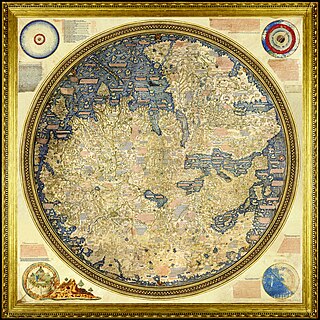
The Fra Mauro map is a map of the world made around 1450 by the Italian (Venetian) cartographer Fra Mauro, which is “considered the greatest memorial of medieval cartography." It is a circular planisphere drawn on parchment and set in a wooden frame that measures over two by two meters. Including Asia, the Indian Ocean, Africa, Europe, and the Atlantic, it is oriented with south at the top. The map is usually on display in the Biblioteca Nazionale Marciana in Venice in Italy.

The Ravenna Cosmography is a list of place-names covering the world from India to Ireland, compiled by an anonymous cleric in Ravenna around 700 AD. Textual evidence indicates that the author frequently used maps as his source.
The earliest known world maps date to classical antiquity, the oldest examples of the 6th to 5th centuries BCE still based on the flat Earth paradigm. World maps assuming a spherical Earth first appear in the Hellenistic period. The developments of Greek geography during this time, notably by Eratosthenes and Posidonius culminated in the Roman era, with Ptolemy's world map, which would remain authoritative throughout the Middle Ages. Since Ptolemy, knowledge of the approximate size of the Earth allowed cartographers to estimate the extent of their geographical knowledge, and to indicate parts of the planet known to exist but not yet explored as terra incognita.
The Geography, also known by its Latin names as the Geographia and the Cosmographia, is a gazetteer, an atlas, and a treatise on cartography, compiling the geographical knowledge of the 2nd-century Roman Empire. Originally written by Claudius Ptolemy in Greek at Alexandria around AD 150, the work was a revision of a now-lost atlas by Marinus of Tyre using additional Roman and Persian gazetteers and new principles. Its translation into Arabic in the 9th century was highly influential on the geographical knowledge and cartographic traditions of the Islamic world. Alongside the works of Islamic scholars - and the commentary containing revised and more accurate data by Alfraganus - Ptolemy's work was subsequently highly influential on Medieval and Renaissance Europe.
Pisa is a modern village situated 2.15 kilometres (1.34 mi) to the east of Olympia, Greece. Currently it is not politically independent but is a neighborhood of the village of Archea Olympia, the capital of the Municipality of Ancient Olympia, of which it is a municipal unit, Ancient Olympia, since 2011. Municipality (deme), municipal unit, village, and ancient site, all telescope at the same location under the same Greek name, archaia Olympia, although different English translations provide some diversity at the different levels. They are all in the regional unit of Elis, located on the northwest side of the geographic feature of the Peloponnesus

Portolan charts are nautical charts, first made in the 13th century in the Mediterranean basin and later expanded to include other regions. The word portolan comes from the Italian portulano, meaning "related to ports or harbors", and which since at least the 17th century designates "a collection of sailing directions".
The history of cartography refers to the development and consequences of cartography, or mapmaking technology, throughout human history. Maps have been one of the most important human inventions for millennia, allowing humans to explain and navigate their way through the world.

Francesco Berlinghieri (1440–1501) was an Italian scholar and humanist who lived during the fifteenth century. He promoted the value of classical Greek learning and was one of the first to print a text based on Ptolemy's Geographica. Berlinghieri studied poetry under the tutelage of Cristoforo Landino.

"Majorcan cartographic school" is the term coined by historians to refer to the collection of predominantly Jewish cartographers, cosmographers and navigational instrument-makers and some Christian associates that flourished in Majorca in the 13th, 14th and 15th centuries until the expulsion of the Jews. The label is usually inclusive of those who worked in Catalonia. The Majorcan school is frequently contrasted with the contemporary Italian cartography school.
The 1119 papal election was, of all the elections currently considered legitimate by the Roman Catholic Church, the smallest papal election of the twelfth century.
Chinese cartography began in the 5th century BC during the Warring States period when cartographers started to make maps of the Earth's surface. Its scope extended beyond China's borders with the expansion of the Chinese Empire under the Han dynasty. By the 11th century during the Song dynasty highly-accurate maps drawn on grids were produced. During the 15th century, the Ming dynasty admiral Zheng He went on a series of voyages to the South China Sea, Indian Ocean, and beyond and maps for areas outside of China were produced, although world maps covering territories known to the Chinese outside of China existed as early as the Tang dynasty.

The Mercator world map of 1569 is titled Nova et Aucta Orbis Terrae Descriptio ad Usum Navigantium Emendate Accommodata. The title shows that Gerardus Mercator aimed to present contemporary knowledge of the geography of the world and at the same time 'correct' the chart to be more useful to sailors. This 'correction', whereby constant bearing sailing courses on the sphere are mapped to straight lines on the plane map, characterizes the Mercator projection. While the map's geography has been superseded by modern knowledge, its projection proved to be one of the most significant advances in the history of cartography, inspiring map historian Nordenskiöld to write "The master of Rupelmonde stands unsurpassed in the history of cartography since the time of Ptolemy." The projection heralded a new era in the evolution of navigation maps and charts and it is still their basis.

The Island of the Jewel or Island of Sapphires was a semi-legendary island in medieval Arabic cartography, said to lie in the Sea of Darkness near the equator, forming the eastern limit of the inhabited world. The island does not appear in any surviving manuscript of Ptolemy's Geography nor other Greek geographers. Instead, it is first attested in the Ptolemaic-influenced Book of the Description of the Earth compiled by al-Khwārizmī around 833. Ptolemy's map ended at 180° E. of the Fortunate Isles without being able to explain what might lay on the imagined eastern shore of the Indian Ocean or beyond the lands of Sinae and Serica in Asia. Roman missions subsequently reached the Han court via Longbian (Hanoi) and Chinese Muslims traditionally credit the founding of their community to the Companion Saʿd ibn Abi Waqqas as early as the 7th century. Muslim merchants such as Soleiman established sizable expatriate communities; a large-scale massacre of Arabs and Persians is recorded at Yangzhou in 760. These connections showed al-Khwārizmī and other Islamic geographers that the Indian Ocean was not closed as Hipparchus and Ptolemy had held but opened either narrowly or broadly.
The cartography of the region of Palestine, also known as cartography of the Holy Land and cartography of the Land of Israel, is the creation, editing, processing and printing of maps of the region of Palestine from ancient times until the rise of modern surveying techniques. For several centuries during the Middle Ages it was the most prominent subject in all of cartography, and it has been described as an "obsessive subject of map art".
References
- ↑ Wolfgang Buchwald, Armin Hohlweg, and Otto Prinz, Dictionnaire des auteurs grecs et latins de l'antiquite et du moyen age, translated and updated by Jean Denis Berger and Jacques Billen (Brepols: 1991), 331.
- ↑ Gašperšič, Primož. "Cartographic Images of Slovenia Through Time" (PDF). Acta Geographica Slovenica. 47 (2): 249. Archived from the original (PDF) on 22 February 2014.