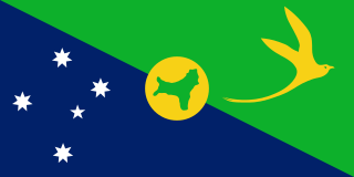
The Territory of Christmas Island is an Australian external territory comprising the island of the same name. Christmas Island is located in the Indian Ocean, around 350 kilometres (220 mi) south of Java and Sumatra and around 1,550 kilometres (960 mi) north-west of the closest point on the Australian mainland. It has an area of 135 square kilometres (52 sq mi).
Maria Island is a mountainous island located in the Tasman Sea, off the east coast of Tasmania, Australia. The 115.5-square-kilometre (44.6 sq mi) island is contained within the Maria Island National Park, which includes a marine area of 18.78 square kilometres (7.25 sq mi) off the island's northwest coast. The island is about 20 kilometres (12 mi) in length from north to south and, at its widest, is about 13 kilometres (8.1 mi) west to east. At its closest point, Point Lesueur, the island lies approximately 4 kilometres (2.5 mi) off the east coast of Tasmania.

The Buccaneer Archipelago is a group of islands off the coast of Western Australia near the town of Derby in the Kimberley region. The closest inhabited place is Bardi located about 54 kilometres (34 mi) from the western end of the island group.

Cartier Island is an uninhabited and unvegetated sand cay in a platform reef in the Timor Sea north of Australia and south of Indonesia. It is within the Territory of Ashmore and Cartier Islands, an external territory of Australia. The land area of Cartier Island is about 0.4 hectares. It is located at 12°31′S123°33′E, on the edge of the Sahul Shelf, about 300 kilometres (190 mi) off the north west coast of Western Australia, 200 kilometres (120 mi) south of the Indonesian island of Roti, and 70 kilometres (43 mi) south-east of Ashmore Reef.

Herdsman Lake, also known as Herdsmans Lake, is a freshwater lake located on the Swan Coastal Plain, 6 kilometres (3.7 mi) north-west of Perth, Western Australia, in the suburb of Herdsman.

The Shire of Cranbrook is a local government area in the Great Southern region of Western Australia, about 92 kilometres (57 mi) north of Albany and about 320 kilometres (199 mi) south-southeast of the state capital, Perth. The Shire covers an area of 3,277 square kilometres (1,265 sq mi), and its seat of government is the town of Cranbrook.

The Shire of Denmark is a local government area in the Great Southern region of Western Australia, about 55 kilometres (34 mi) west of Albany and about 420 kilometres (261 mi) south-southeast of the state capital, Perth. The Shire of Denmark covers an area of 1,860 square kilometres (718 sq mi), and its seat of government is located in the townsite and locality of Denmark.

Jaksonowice is a village in the administrative district of Gmina Długołęka, within Wrocław County, Lower Silesian Voivodeship, in south-western Poland. Prior to 1945 it was in Germany.

The Shire of Phillip Island was a local government area in Western Port about 120 kilometres (75 mi) south of Melbourne, the state capital of Victoria, Australia. The shire covered an area of 101.05 square kilometres (39.0 sq mi), and existed from 1928 until 1994.
Pokrzywna is a village in the administrative district of Gmina Rawa Mazowiecka, within Rawa County, Łódź Voivodeship, in central Poland. It lies approximately 6 kilometres (4 mi) north of Rawa Mazowiecka and 54 km (34 mi) east of the regional capital Łódź.
Grabówka is a village in the administrative district of Gmina Lubomia, within Wodzisław County, Silesian Voivodeship, in southern Poland. It lies approximately 2 kilometres (1 mi) south-east of Lubomia, 11 km (7 mi) west of Wodzisław Śląski, and 55 km (34 mi) south-west of the regional capital Katowice.
Trzebiele is a settlement in the administrative district of Gmina Białogard, within Białogard County, West Pomeranian Voivodeship, in north-western Poland. It lies approximately 5 kilometres (3 mi) north-west of Białogard and 112 km (70 mi) north-east of the regional capital Szczecin.
Irvine Island is located off the Kimberley coast of Western Australia in the Buccaneer Archipelago. It is about 250 km (160 mi) north-east of Broome, 140 km (87 mi) north of Derby and hosts an unmined deposit of iron ore. Irvine Island has a surface area of 893 hectares and is 5 kilometres (3 mi) west of Cockatoo Island.

The Egg Islands are a small group of low-lying estuarine islands in the tidal lower reaches of the Huon River of south-east Tasmania, Australia. They face the town of Franklin which lies on the western bank of the river.
Gulch Island may refer to:
Nanarup Beach is a beach in the Great Southern region of Western Australia, 20 kilometres (12 mi) east of Albany.

Nepean Bay is a bay located on the north-east coast of Kangaroo Island in the Australian state of South Australia about 130 kilometres south-south-west of Adelaide. It was named by the British navigator, Matthew Flinders, after Sir Evan Nepean on 21 March 1802.
Doubtful Islands are a group of three small islands located approximately 3 kilometres (2 mi) offshore of Point Hood and approximately 20 kilometres (12 mi) east of Bremer Bay in Western Australia.
Salisbury Island is located in the Recherche Archipelago off the south coast of Western Australia.

County of Fergusson is a cadastral unit located in the Australian state of South Australia which spans Yorke Peninsula south of Price. It was proclaimed in 1869 by Governor Fergusson after whom the county was named.


