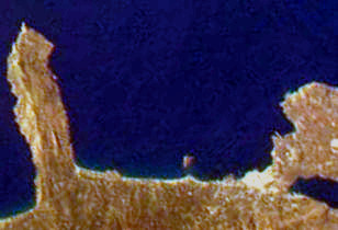
The Gulf of Chania is an embayment of the Sea of Crete in the northwestern region of the island of Crete in present-day Greece. One headland forming the Gulf of Chania is the promontory known as the Akrotiri Peninsula. [1]
The Gulf of Chania is an embayment of the Sea of Crete in the northwestern region of the island of Crete in present-day Greece. One headland forming the Gulf of Chania is the promontory known as the Akrotiri Peninsula. [1]
In prehistory the powerful city of Kydonia commanded the Gulf of Chania and was a center of early Cretan art and culture in western Crete. [2] By 74 BC the city-state of Kydonia fended off an attack by Rome in a naval battle in the Gulf of Chania. [3]

Crete is the largest and most populous of the Greek islands, the 88th largest island in the world and the fifth largest island in the Mediterranean Sea, after Sicily, Sardinia, Cyprus, and Corsica. It bounds the southern border of the Aegean sea. Crete lies approximately 160 km (99 mi) south of the Greek mainland. It has an area of 8,336 km2 (3,219 sq mi) and a coastline of 1,046 km (650 mi).

Chania is the second largest city of Crete and the capital of the Chania regional unit. It lies along the north coast of the island, about 70 km (43 mi) west of Rethymno and 145 km (90 mi) west of Heraklion.

The Sea of Crete or Cretan Sea, is a sea, part of the Aegean Sea, located in its Southern extremity. The sea stretches to the North of the island of Crete, East of the islands of Kythera and Antikythera, South of the Cyclades, and West of the Dodecanese islands of Rhodes, Karpathos and Kassos. The bounding sea to the West is the Ionian Sea. To the Northwest is the Myrtoan Sea, a subdivision of the Mediterranean Sea that lies between the Cyclades and Peloponnese. To the East-SE is the rest of the Mediterranean Sea, sometimes credited as the Levantine Sea. Across the island of Crete, to the opposite shore of it begins the Libyan Sea. Ferry routes to and from Piraeus and Heraklion, as well as the Southern islands of the Aegean and the Dodecanese, run in this area. Just off the coastline of Northeastern Crete the sea reaches a maximum depth of near 3,294 m. Other sources (maps) show a maximum depth of 2,591 m..

Akrotiri is a peninsula and former municipality in the Chania regional unit, Crete, Greece. Since the 2011 local government reform it is part of the municipality Chania, of which it is a municipal unit. The municipal unit has an area of 112.644 km2 (43.492 sq mi). Its ancient name was Kiamon while the Byzantines called it Charaka. The seat of Akrotiri municipality was Pythari. Stavros became famous because of the film Zorba the Greek.

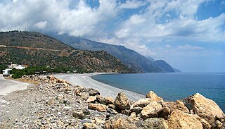
Chania is one of the four regional units of Crete; it covers the westernmost quarter of the island. Its capital is the city of Chania. Chania borders only one other regional unit: that of Rethymno to the east. The western part of Crete is bounded to the north by the Cretan Sea, and to the west and south by the Mediterranean Sea. The regional unit also includes the southernmost island of Europe, Gavdos.

Kydonia or Cydonia was an ancient city-state on the northwest coast of the island of Crete. It is at the site of the modern-day Greek city of Chania. In legend Cydonia was founded by King Cydon (Κύδων), a son of Hermes or Apollo and of Akakallis, the daughter of King Minos. According to Pausanias he was son of king Tegeates.

Souda Bay is a bay and natural harbour near the town of Souda on the northwest coast of the Greek island of Crete. The bay is about 15 km long and only two to four km wide, and a deep natural harbour. It is formed between the Akrotiri peninsula and Cape Drapano, and runs west to east. The bay is overlooked on both sides by hills, with a relatively low and narrow isthmus in the west near Chania.

Nea Kydonia is a former municipality in the Chania regional unit, Crete, Greece. Since the 2011 local government reform it is part of the municipality Chania, of which it is a municipal unit. The municipal unit has an area of 21.457 km2 (8.285 sq mi). It is situated on the western outskirts of Chania. It saw fierce fighting during the Battle of Crete during World War II and there the main prisoner of war camp for Allied soldiers in Western Crete was in Galatas.
Elyrus or Elyros was a town of ancient Crete, which the Periplus of Pseudo-Scylax places between Cydonia and Lissus. It had a harbour, Syia (Συΐα), situated on the south coast of the island, 60 stadia west of Poecilassus. Pausanias states that the city existed in his time in the mountains of Crete. He adds that he had seen at Delphi the bronze goat which the Elyrians had dedicated, and which was represented in the act of giving suckle to Phylacis and Phylander, children of Apollo and the nymph Acacallis, whose love had been won by the youthful god at the house of Casmanor at Tarrha. It was the birthplace of Thaletas, who was considered as the inventor of the Cretic rhythm, the national paeans and songs, with many of the institutions of his country. Elyrus appears in Hierocles' list of Cretan cities, then reduced in number to twenty-one. The coins of this city have the type of a bee upon them.
Sougia is a community and a small village in Chania regional unit on the island of Crete, Greece. It is part of the municipal unit of East Selino. It is located on the south coast of the island, 70 km south of Chania. The community consists of the following villages :

Aptera also called Apteron was an ancient city, now an archaeological site in western Crete, a kilometre inland from the southern shore of Souda Bay, about 13 km east of Chania in the municipality of Akrotiri.

The Archaeological Museum of Chania is a museum located in the former Venetian Monastery of Saint Francis at 28 Chalidon Street, Chania, Crete, Greece. It was established in 1962.
Mount Tityros is a hill landform in western Crete in the vicinity of the modern-day city of Chania, Greece. In ancient times Mount Tityros was associated with the early Cretan city of Kydonia. Residents of the ancient city of Kydonia dedicated a temple to the goddess Britomartis on Mount Tityros.
Malaxa is a village in the Chania regional unit on Crete in Greece. The 2011 census counted a population of 115 people in the village. In ancient times the Malaxa area was under the sphere of influence of the nearby powerful city of Kydonia. Malaxa lies on the feet of the Lefka Ori, and is separated from the large city of Chania by the Chania Plain.
Kastri is a village in the island of Cythera, Islands regional unit, Greece. Kastri has been occupied by humans since the Bronze Age, and was an important settlement of the Early Helladic/Minoan Period of Crete. Kastri is thought to have been an early settlement of Minoan Crete. Kastri on Cythera is considerably but directly north of the ancient site of Kydonia, which was the major northwestern Cretan ancient city.
The Chania Plain is a relatively level landform spreading southward from the city of Chania on the island of Crete in the present day country of Greece. The Chania Plain has been used as a logical study area for air pollution transport in the vicinity of Chania. In ancient times the city of Kydonia, the site of present-day Chania, controlled an expansive area which included the Chania Plain lying to its south at least to Malaxa Mountain.

Mirabello Bay is an embayment of the Sea of Crete on the eastern part of Crete in present-day Greece. It is the largest bay of the Greek islands and the fifth largest in the Mediterranean Sea. The tourist town Agios Nikolaos overlooks the bay. This locale was important in prehistoric settlement of the island of Crete.
Malaxa Mountain is a mountain at Malaxa on the island of Crete in the country of Greece. This mountain feature is situated in northwestern coastal Crete in the vicinity of the city of Chania. Trypali limestone is a dominant rock of Malaxa Mountain. The ancient city of Kydonia held sway over lands to the south of it across the Chania Plain all the way to Malaxa Mountain.
Kastelli Hill is a landform at the city of Chania on the island of Crete in the present day country of Greece. The Minoan city of ancient Cydonia was centered on Kastelli Hill, which later was selected by the Romans as the site of an acropolis.
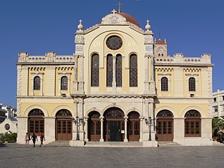
The Church of Crete is an Eastern Orthodox Church, comprising the island of Crete in Greece. The Church of Crete is semi-autonomous (self-governing) under the jurisdiction of the Ecumenical Patriarchate of Constantinople. The current Archbishop of Crete is, since 30 August 2006, Irinaios Athanasiadis.
Coordinates: 35°35′13″N23°54′50″E / 35.587°N 23.914°E
| This Crete location article is a stub. You can help Wikipedia by expanding it. |