Gulf of Papagayo

Last updated
Gulf of Papagayo seen from space Gulf of Papagayo NASA.jpg
Gulf of Papagayo seen from space

The Gulf of Papagayo (Spanish : Golfo del Papagayo, meaning "gulf of the parrot") is a large body of water off Guanacaste province and the northwestern coast of Costa Rica. The Gulf and its coastline are part of a major tourism project by Costa Rica's government. Among the most popular destinations on the Gulf of Papagayo are Ocotal Beach, Playas del Coco, Playa Hermosa, and Playa Panama. The Papagayo peninsula is the most developed area in the gulf region.[ citation needed ] The gulf waters are home to many wildlife including orcas. [1]
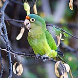
A wild orange-fronted parakeet, orange-fronted conure, or half-moon conure (Aratinga canicularis) near a beach facing the Gulf of Papagayo Eupsittula canicularis, Gulf of Papagayo, Costa Rica 1.jpg
A wild orange-fronted parakeet, orange-fronted conure, or half-moon conure (Aratinga canicularis) near a beach facing the Gulf of Papagayo

10°42′N85°48′W / 10.7°N 85.8°W / 10.7; -85.8

Related Research Articles

<span class="mw-page-title-main">Yaiza (municipality)</span> Municipality in Canary Islands, Spain

Yaiza is a municipality on the island of Lanzarote in the Canary Islands, Spain. It lies in the southwest of the island and forms part of the province of Las Palmas. The municipality is bounded by the Atlantic Ocean to the west, south and east. To the north, the Timanfaya National Park is partly within the municipality. The eastern part of the municipality is mountainous and, south west of the mountains, the Rubicon plain stretches to the coast.

<span class="mw-page-title-main">Guanacaste Province</span> Province of Costa Rica

Guanacaste is a province of Costa Rica located in the northwestern region of the country, along the coast of the Pacific Ocean. It is bordered by Nicaragua to the north, Alajuela Province to the east, and Puntarenas Province to the southeast. It is the most sparsely populated of all the provinces of Costa Rica. The province covers an area of 10,141 square kilometres (3,915 sq mi) and as of 2010, had a population of 354,154, with annual revenue of $2 million.

<span class="mw-page-title-main">Liberia, Costa Rica</span> District in Guanacaste, Costa Rica

Liberia is a district and the largest city in the Guanacaste Province of Costa Rica, located 215 kilometres (134 mi) northwest of the national capital, San José, which is also in the Guanacaste canton. It is a major center for the country's tourism industry.

<span class="mw-page-title-main">Great green macaw</span> Species of bird

The great green macaw, also known as Buffon's macaw or the great military macaw, is a critically endangered Central and South America parrot found in Nicaragua, Honduras, Costa Rica, Panama, Colombia and Ecuador. Two allopatric subspecies are recognized; the nominate subspecies, Ara ambiguus ssp. ambiguus, occurs from Honduras to Colombia, while Ara ambiguus ssp. guayaquilensis appears to be endemic to remnants of dry forests on the southern Pacific coast of Ecuador. The nominate subspecies lives in the canopy of wet tropical forests and in Costa Rica is usually associated with the almendro tree, Dipteryx oleifera.

<span class="mw-page-title-main">Nicoya Peninsula</span> Peninsula

The Nicoya Peninsula is a peninsula on the Pacific coast of Costa Rica. It is divided into two provinces: Guanacaste Province in the north, and the Puntarenas Province in the south. It is located at 10°N 85.4166667°W. It varies from 19 to 37 miles (60 km) wide and is approximately 75 miles (121 km) long, forming the largest peninsula in the country. It is known for its beaches and is a popular tourist destination.

Iguanita Wildlife Refuge is a wildlife refuge in the Guanacaste Conservation Area located in the Guanacaste Province of northwestern Costa Rica.

<span class="mw-page-title-main">Playa Negra, Costa Rica</span>

Tamarindo River is a river in the Guanacaste Province of Costa Rica. The estuary is adjacent to the town of Tamarindo. The river spans 490 hectares and serves as the natural border between Tamarindo and Playa Grande. The estuary is home to much wildlife, including ospreys, herons and kingfishers in addition to howler monkeys and coatimundis. In particular, it hosts the American Crocodile, which draws tourists to the estuary. The river estuary is a popular place for surfing despite the local caiman population.

<span class="mw-page-title-main">Carrillo (canton)</span> Canton in Guanacaste province, Costa Rica

Carrillo is a canton in the Guanacaste province of Costa Rica. The head city is in Filadelfia district.

<span class="mw-page-title-main">Tourism in Costa Rica</span>

Tourism in Costa Rica has been one of the fastest growing economic sectors of the country and by 1995 became the largest foreign exchange earner. Since 1999, tourism has earned more foreign exchange than bananas, pineapples and coffee exports combined. The tourism boom began in 1987, with the number of visitors up from 329,000 in 1988, through 1.03 million in 1999, over 2 million in 2008, to a historical record of 2.66 million foreign visitors in 2015. In 2012, tourism contributed with 12.5% of the country's GDP and it was responsible for 11.7% of direct and indirect employment. In 2009, tourism attracted 17% of foreign direct investment inflows, and 13% in average between 2000 and 2009. In 2010, the tourism industry was responsible for 21.2% of foreign exchange generated by all exports. According to a 2007 report by ECLAC, tourism contributed to a reduction in poverty of 3% in the country.

<span class="mw-page-title-main">Papagayo Peninsula</span>

Papagayo Peninsula is located on the north Pacific coast of Costa Rica in the northwest province of Guanacaste. It is located in the Golfo de Papagayo and was formed by volcanic activity as the Caribbean tectonic plate continuously overrode the Cocos Plate and by subsequent weather erosion. The 15 miles (24 km) at the coastline contains 31 separate beaches. The larger Elena Peninsula Santa to the north protects the waters in the Papagayo Peninsula.

<span class="mw-page-title-main">Playas del Coco</span>

Playas del Coco is one of the oldest beach communities in Guanacaste Province, Costa Rica. This region is also one of the fastest-growing tourism areas in Costa Rica. A popular destination for both local Costa Ricans and visitors from other countries during the traditional holiday seasons, local Costa Ricans refer to Playas del Coco affectionately as "El Coco". At the same time, travelers from outside of Costa Rica use the name "Coco Beach", when mentioning this locale.

Playa Flamingo is one of Costa Rica's most popular beaches with fine white sand. It has pristine clear blue waters, lagoons, vegetation and abundance of activities. The Playa Flamingo area offers a wide variety of secluded beaches and lagoons due to the mountain formations reaching into the sea. It features hotels, lodging, luxury homes, entertainment, water, land and leisure activities.

Playa Cativo is an eco-lodge located in Golfo Dulce, Costa Rica.

Okenia academica is a species of sea slug, specifically a dorid nudibranch, a marine gastropod mollusc in the family Goniodorididae.

The 2015 CONCACAF Beach Soccer Championship was a beach soccer tournament which took place in Costa del Sol, El Salvador on 28 March – 4 April 2015. This was the first time the CONCACAF Beach Soccer Championship was held in Central America. All matches were played at Estadio de Fútbol Playa in La Paz Department, with an official capacity of 2,000.

<span class="mw-page-title-main">Papagayo Jet</span>

The Papagayo jet, also referred to as the Papagayo Wind or the Papagayo Wind Jet, are strong intermittent winds that blow approximately 70 km north of the Gulf of Papagayo, after which they are named. The jet winds travel southwest from the Caribbean and the Gulf of Mexico to the Pacific Ocean through a pass in the Cordillera mountains at Lake Nicaragua. The jet follows the same path as the northeast trade winds in this region; however, due to a unique combination of synoptic scale meteorology and orographic phenomena, the jet winds can reach much greater speeds than their trade wind counterparts. That is to say, the winds occur when cold high-pressure systems from the North American continent meet warm moist air over the Caribbean and Gulf of Mexico, generating winds that are then funneled through a mountain pass in the Cordillera. The Papagayo jet is also not unique to this region. There are two other breaks in the Cordillera where this same phenomenon occurs, one at the Chivela Pass in México and another at the Panama Canal, producing the Tehuano (Tehuantepecer) and the Panama jets respectively.

Punta Islita is a resort town in the Nandayure Canton, Guanacaste Province of Costa Rica. The Punta Islita Airport is located in the nearby town of Corozalito.

The Papagayo are strong winds that blow north of the Gulf of Papagayo.

References

  1. ANNIE. 2012. Orca Whales. Costa Rica Scuba.com. Retrieved on August 25, 2017