
Central Equatoria is a state in South Sudan. With an area of 43,033 square kilometres (16,615 sq mi), it is the smallest of the original South Sudanese states. Its previous name was Bahr al-Jabal, named after a tributary of the White Nile that flows through the state. It was renamed Central Equatoria in the first Interim Legislative Assembly on 1 April 2005 under the government of Southern Sudan. Central Equatoria seceded from Sudan as part of the Republic of South Sudan on 9 July 2011. The state's capital, Juba, is also the national capital of South Sudan. On October 2, 2015, the state was split into three states: Jubek, Terekeka, and Yei River. The state of Central Equatoria was re-established by a peace agreement signed on 22 February 2020.
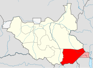
Eastern Equatoria is a state in South Sudan. It has an area of 73,472 km2. The capital City is Torit. On October 1, 1972, the state was divided into Imatong and Namorunyang states and was re-established by a peace agreement signed on 22 February 2020.

Juba is the capital and largest city of South Sudan. The city is situated on the White Nile and also serves as the capital of the Central Equatoria State. It is the most recently declared national capital and had a population of 525,953 in 2017. It has an area of 52 km2 (20 sq mi), with the metropolitan area covering 336 km2 (130 sq mi).
Kaya is a city in Central Equatoria, South Sudan.

Magwi County, also Magwe County, is a county in Eastern Equatoria, South Sudan.

Mukaya Payam is situated in Lainya County in central Equatoria State, South Sudan; It was a former local administrator head for current Yei river county. The name (Mukaya) originated from Hill located about in central of the Mukaya geographical land, which is around 9 to 12 miles north of Yei river County. The Mukaya differentiates into smaller clans of Dimo (1), Dimo (2), Dimo na Godo, Rume, Kendire, Goromba, Mingale, Jolobong, Mijikango, Dongbong, Pisak, Piyasuk, Bori, Yondoru, Sowaka, Ligi, Girim, Yensot, Migibura, Bono, Muresuku, Morsak, Gokoni, Malari, Worokosuk, Bujang, Mika, Warijang, Gori, Kobo, Nyori, Morsak, Bonga, Mikatom, Jubor, and a few other smaller ones. The population of the Mukaya Payam is estimated to be 15,000 persons.
Torit County is an administrative region in Eastern Equatoria of South Sudan, with headquarters in the town of Torit, which is also the state capital.

Magwi is a town in South Sudan. It is the capital, business center and home to the Acholi tribe of South Sudan.
Budi County is an administrative area of Eastern Equatoria state in South Sudan, with headquarters in Chukudum.
Kapoeta East County is an administrative region of Eastern Equatoria state in South Sudan, bordered by Kenya to the south, Ethiopia to the east and Jonglei state to the west. It is part of the Greater Kapoeta region of the state. The largest ethnic group is the Toposa people. The principal town is Narus. The county includes the disputed Ilemi triangle, controlled by Kenya. The emblem of the county is a horned bull, with big humps and a large tail.

Juba County is an administrative area in Central Equatoria state, South Sudan. It is the largest county in Central Equatoria and one of the largest in the region of Equatoria. Its county seat is Juba, the national capital of the South Sudan.
Morobo is one of the six counties in Central Equatoria state, South Sudan. Morobo County borders Uganda and Congo. The county is mainly occupied by Kakwa speaking people, Keliko and Lugbara. The people in Morobo are local farmers working for food. Morobo is part of the green belt and also acts as a breadbasket for Yei and Juba.
Kolnyang is a Payam in Bor County, in Jonglei State, South Sudan. It is situated on the east side of the Bahr al Jabal River, to the south of Bor, South Sudan. Kolnyang’s Malual-Chaat was where the liberation revolution that led to South Sudan independence started. Both 105 Battalion commander Alier NhialMangardit and the first fallen hero of revolt Maker Jool were from Kolnyang. Kolnyang Payam is Bor county’s southernmost payam, bordering Central Equatoria State to southwest, Pibor Administrative Area to the east, Lake State to the west and Eastern Equatoria State to the southeast.

Yei River State was a state in South Sudan that existed from 2 October 2015 to 22 February 2020.
Nagero County is one of the 10 counties of Western Equatoria, a state of South Sudan
Kuron is a boma in Kauto Payam, Kapoeta East County, Namorunyang State, South Sudan.
Yei River County is an administrative area in Central Equatoria with a large population of people who settled in that particular county.
Kimba is a Payams Located in Morobo County, South Sudan bordering the DR Congo and Uganda.
River Yei is a river in South Sudan with its source in Panyana Village, Lujule payam in Morobo County of Central Equatoria State.
Aga Fall is a waterfall on the River Yei in the Geri Boma of Wudabi payam, Morobo County in Central Equatoria, South Sudan.
