Morobo County

Last updated
Morobo County
Central Equatoria State Counties.svg
Country South Sudan
State Central Equatoria
Government
  CommissionerJoseph Mawa Ukuba
Area
  Total1,304 km2 (503 sq mi)
Population
 (2017)
  Total148,023 [1]
Time zone UTC+2 (CAT)
Joseph Mawa, the current commissioner, Morobo County Joseph Mawa The Commisioner of Morobo County.jpg
Joseph Mawa, the current commissioner, Morobo County

Morobo is one of the six counties in Central Equatoria state, South Sudan. [2] [3] Morobo County borders Uganda and Congo. The county is mainly occupied by Kakwa speaking people, Keliko and Lugbara. The people in Morobo are local farmers working for food. Morobo is part of the green belt and also acts as a breadbasket for Yei and Juba. [4]

Contents

There has been sporadic violence in Morobo County since the establishment of South Sudan at the end of the Second Sudanese Civil War. [4] The UN is working with locals to address these issues. [5]

Joseph Mawa is the current commissioner of Morobo County. [6]

Demography

The Demographics of Morobo County
2008 Census population103,603
2020 Population projection104,106
Major ethnic groups Kakwa, Keliko, Lugbara
Languages Kakwa, Kaliko, Lugbara
Displacement Figures: IDPs2,495
Boardering Counties Lainya, Yei, Kajo-Keji
Nearby Countries Uganda and Democratic Republic of Congo
Displacement Figures: returnees7,564

Payams of Morobo

Morobo county is located in Central Equatoria state and its close to Democratic Republic of Congo and Uganda which it borders. It has five Payams - Lujule, Gulumbi, Kimba, Wudabi and Panyume Payam. Each Payam consist of several Bomas

Gulumbi

Kimba

Lujulo West

Panyume

Wudabi

Economy and livelihood

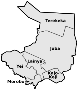
Morobo County is located in the state of Central Equatoria. It is bounded to the north-west by Yei County, to the north-east by Lainya County, to the south-east by Uganda, and to the south-west by the Democratic Republic of the Congo. [7]

The county is located in South Sudan's greenbelt and has fertile soil, making it an ideal location for agricultural activities. Morobo County, according to FEWSNET (2018), is in the equatorial maize and cassava livelihoods zone. Groundnuts, sorghum, milt, banana, cassava, and maize are among the most common and marketable crops grown in the region, but farmers frequently struggle to obtain quality seeds due to trade and transportation issues.

A REACH assessment in 2018 revealed that while 88% of the population had access to a functional market, 100% of the population was estimated to be receiving food aid, and 88% relied on subsistence agriculture to support their households. Furthermore, families in the area reported eating one meal per day on average. Due to "unsafe access to land," half of the population was reported to be food insecure. Aside from agricultural occupations, half of the population reported owning cattle. The county is also well known for mineral extraction in South Sudan. According to a Cordaid report published in 2016, there were approximately 5,000 artisanal gold miners operating in the area, but it is unclear how much of this number has been impacted by the conflict. [7]

Climate

Morobo has a tropical savanna climate (Köppen: Aw). It is warm every month with both a wet and dry season. The average annual temperature for Morobo is 29° degrees and there is about 981 mm of rain in a year. It is dry for 115 days a year with an average humidity of 68% and an UV-index of 6. [8]

Climate Morobo by month

JanFebMarAprMayJunJulAugSepOctNovDec
Day temp. (°C)333432302828272728282830
Night temp. (°C)192121191817171717181819
JanFebMarAprMayJunJulAugSepOctNovDec
Precipitation (mm)3133790110931041251261828811
Days with rain341221262528292928176
Dry days28241995532131325
JanFebMarAprMayJunJulAugSepOctNovDec
Sun hours per day10101099999109910
Wind force (Bft)222222111222
UV-index776666666667

Infrastructure and services

Morobo County is located on the border with Uganda, making it a vital area for both human migration and trade. Kaya is one of the county's unofficial migration points. However, insufficient infrastructure, particularly roads and affordable transportation options, limits Morobo residents' ability to expand their agricultural activities to commercial levels. Residents' ability to access their land for subsistence agricultural livelihoods has also been hampered by the area's insecurity. Insecurity in the area, particularly in 2017, has resulted in the deterioration of schools, clinics, and homes, as well as the destruction of crops.

According to OCHA's (2019) Humanitarian Needs Overview for 2020, Morobo County has an estimated 81,200 people in need, which is approximately 78% of the estimated population reported in the HNO. According to the same report, Morobo County has the highest level of recorded landmine and explosive remnants of war, which have proliferated as a result of the recent conflict in the Equatoria region. This is especially problematic given the high number of IDP border crossings in the area. Landmines have also made it difficult for residents to access basic services in the area, such as healthcare and schools.

Conflict dynamics

Prior to 2016, Morobo County had avoided the worst of the national conflict and was regarded as one of the most stable areas in the country. Armed militia robberies, on the other hand, were common and sometimes deadly. Because of its proximity to Uganda and the Democratic Republic of the Congo, the county is home to a large number of South Sudanese returnees from those countries. Due to border demarcation disputes, there was some tension between communities on both sides of the border with the DRC. According to local media reports, a conflict between residents near the border sparked by the alleged raising of DRC flags in Morobo villages was referred to the national government in May 2016. (Gilbert, 2016). When conflict erupted for the second time in 2016, Morobo County was one of the areas in Central Equatoria where opposition forces fled and remained.

According to VOA (2019), civilians were targeted by armed forces in addition to being caught in the crossfire between government and opposition forces. [9] Attacks on humanitarian workers have also occurred in Morobo. Two aid workers were killed in April 2016 near Gulumbi Village. Armed groups kidnapped and killed three IOM staff monitoring the border for Ebola in Kaya, Morobo County, in October 2019. (IOM, 2019). This resulted in the indefinite suspension of border monitoring. Despite the signing of the R-ARCISS in 2018, the National Salvation Front (NAS), a non-signatory to the agreement, continues to operate in the area, causing insecurity in the county.

Administration and logistics

Payams: Kimba (County Headquarters), Gulumbi, Lujule, Panyume, Wudabi

Main roads:

Rivers in Morobo County

Pollution

Bush burning is rampant in Morobo County, degrading the environment.

Mountain.

Lujule Mountain, Morobo County Lujule Mountain in Morobo.jpg
Lujule Mountain, Morobo County

Secondary schools in Morobo County

Schools in Morobo County have faced challenges from conflict and the displacement of people from other areas. [10]

Languauges spoken by people of Morobo county South Sudan.

  1. Keliko.
  2. Kakwa.
  3. Arabic.
  4. lou.
  5. French.
  6. English.
  7. Lingala.

Primary schools in morobo

Markets

Related Research Articles

<span class="mw-page-title-main">Kakwa people</span> Ethnic group native to Africa

The Kakwa people are a Nilotic ethnic group and part of the Karo people found in north-western Uganda, south-western South Sudan, and north-eastern Democratic Republic of the Congo, particularly to the west of the White Nile river.

<span class="mw-page-title-main">Central Equatoria</span> State of South Sudan

Central Equatoria is a state in South Sudan. With an area of 43,033 square kilometres (16,615 sq mi), it is the smallest of the original South Sudanese states. Its previous name was Bahr al-Jabal, named after a tributary of the White Nile that flows through the state. It was renamed Central Equatoria in the first Interim Legislative Assembly on 1 April 2005 under the government of Southern Sudan. Central Equatoria seceded from Sudan as part of the Republic of South Sudan on 9 July 2011. The state's capital, Juba, is also the national capital of South Sudan. On October 2, 2015, the state was splited into three states: Jubek, Terekeka, and Yei River. The state of Central Equatoria was re-established by a peace agreement signed on 22 February 2020.

Kaya is a city in Central Equatoria, South Sudan.

Yambio is a city in South Sudan.

<span class="mw-page-title-main">Keliko people</span> Ethnic group

The Keliko or Kaliko are an ethnic group in South Sudan and the Democratic Republic of the Congo, with immigrants in Uganda. Most members of the Keliko are Christians. In the Democratic Republic of the Congo, they are called kaliko umi, more especially from Laibo, Mado, awubha awuzi and so on. There is a slight pronunciation between Kaliko people in South Sudan and those in the DRC.

Avokaya is a Central Sudanic language spoken in southern South Sudan and parts of the Democratic Republic of Congo.

<span class="mw-page-title-main">Lainya County</span> County in Central Equatoria, South Sudan

Lainya is a county in Central Equatoria State, South Sudan. Emmanuel Khamis Richard is the current commissioner of Lainya County.

Keliko (Kaliko) is a Central Sudanic language of the Democratic Republic of the Congo and South Sudan.

<span class="mw-page-title-main">Imatong State</span> State of South Sudan from 2015 to 2020

Imatong State was a state in South Sudan that existed between 2 October 2015 and 22 February 2020. It was located in the Equatoria region and it bordered Yei River to the southwest, Jubek to the west, Terekeka and Jonglei to the northwest, Boma to the northeast, Namorunyang to the east, and Uganda to the south.

<span class="mw-page-title-main">Yei River State</span> State of South Sudan from 2015 to 2020

Yei River State was a state in South Sudan that existed from 2 October 2015 to 22 February 2020, when it became a part of the state of Central Equatoria.

<span class="mw-page-title-main">Yei River County</span> County in Central Equatoria, South Sudan

Yei River County is an administrative area in Central Equatoria with a large population of people who settled in that particular county.

Kajo Keji County is an administrative area in Central Equatoria, South Sudan.

Kimba is a Payams Located in Morobo County, South Sudan bordering the DR Congo and Uganda.

Panyume is a place located in Morobo County of Central Equatoria State, South Sudan and also serves as the administrative area of Panyume payam.

River Yei is a river in South Sudan with its source in Panyana Village, Lujule payam in Morobo County of Central Equatoria State.

Aga Fall is a waterfall on the River Yei in the Geri Boma of Wudabi payam, Morobo County in Central Equatoria, South Sudan.

Gulumbi is a payam in Morobo County, Central Equatoria State, South Sudan. The village and Payam headquarters is located along Yei - Kaya.

<span class="mw-page-title-main">Moro Isaac Jenesio</span> South Sudanese politician

Moro Isaac Jenesio is one of the Youthful Leaders of South Sudan. Moro is currently the Minister of Local Government and Law Enforcement for Central Equatoria State in the Transitional Government of National Unity, as of 2023. He is also the Chairperson of the South Sudan National Movement for Change (SSNMC), a constituent Member of South Sudan Opposition Alliance (SSOA) which is one of the leading Partners to RARCSS 2018 South Sudan.

Naphtali Hassan Gale was a South Sudanese politician from Morobo County, a Keliko by tribe. He was a member of Parliament in the Central Equatoria State Parliamentary House representing Lujule West and Wudabi Payams of Morobo County.

Tore is an administrative area and one of the four Payams of Yei River County, Central Equatoria State, South Sudan. its located in the west of Yei and is the biggest town in the region and serves as the Administrative headquarter of Yei River It's located 48 miles maridi road with four boma of mundu, Baka,avokaya and Adio boma

References

  1. "Morobo (County, South Sudan) - Population Statistics, Charts, Map and Location".
  2. "Additional 5 counties established in Yei River State". gurtong. Retrieved 2016-08-12.
  3. "Seed Fair in Morobo". fao.org. Food and Agriculture Organization . Retrieved 2012-07-19.
  4. 1 2 "Morobo".
  5. "Morobo County residents call on armed forces to unite to protect civilians".
  6. Independent, The (2022-12-21). "UPDF to redeploy along Uganda-South Sudan border". The Independent Uganda. Retrieved 2023-01-13.
  7. 1 2 "Morobo". csrf-southsudan.org. Retrieved 2023-01-13.
  8. "Morobo climate ☀️ Best time to visit 🌡️ Temperature". www.besttimetovisit.co.nz. Retrieved 2023-05-15.
  9. https://www.voanews.com/archive/five-civilians-killed-south-sudan-government-rebels-trade-blame.{{cite news}}: Missing or empty |title= (help)[ dead link ]
  10. "Amid conflict and poverty, this school in South Sudan is an unlikely success". TheGuardian.com . 28 October 2014.
  11. "MOROBO COUNTY COMMISSIONER VISITS KANYARA SECONDARY SCHOOL". 18 March 2013.

3°40′09″N30°52′36″E / 3.6693°N 30.8766°E / 3.6693; 30.8766