Terekeka County

Last updated
Terekeka County
Central Equatoria State Counties.svg
Central Equatoria State Counties
Country South Sudan
State Central Equatoria
Headquarters Terekeka
Population
 (2008)
  Total140,396
Time zone UTC+2 (CAT)

Terekeka County is an administrative division of Central Equatoria in South Sudan. [1] It is the capital of surrounding Mundari and Boma counties. It lies on both the east and west bank of the White Nile north of Juba The word "Terekeka" is a combination of two words; "Tirgigi", a kind of hard shrub and "Terere" an open hard ground usually found in the middle of shrub trees. The local referral of "Terere i Tirgigi lukata" became shortened and distorted to create the current name, "Terekeka".

Contents

The current commissioner for Terekeka County is Warnyank Lukö Buyu who replaced James Lino Malou in a republican decree by President Salva Kiir in November 2022. [2]

Location

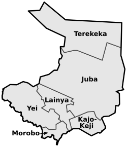
Terekeka County is located at the northern edge of Central Equatoria State. It borders Juba County to the south, Western Equatoria State to the west, Lakes State and Jonglei State to the north, and Eastern Equatoria State to the east. The county contains both low lying swamps and hills in the southern portion of the county. The Nile River runs down the eastern bank of Terekeka Town and Lake Madi is located in the county’s west. [3]

Terekeka was carved out of Juba County in 2001. The main inhabitants of Terekeka county are the Mundari people. [4] In January 2009, Terekeka became the 25th Diocese of the Episcopal Church of the Sudan. The new diocese was headed by Rt. Rev. Micah L. Dawoudi, former Assistant Bishop of Juba Diocese. [5]

Administration and Logistics

There are ten payams in Terekeka namely; Terekeka (County Headquarters), Gameiza, Nyori, Mangala North, Munia, Reggo, Rijong, Tali, Tombek, and Tindilo. [3]

Two major roads are found in the area with the primary road running through Terekeka linking Lakes State’s Yirol to its north and Juba to its south. The roads to Yirol and Juba are accessible during the dry season, however they face “road warnings” in the rainy season. [3]

The secondary road heading west to Mundri East County, also faces “road warnings” in both the rainy and dry season, potentially due to sporadic insecurity. [3]

Economy

The county include low-lying swampy areas that are usually flooding but provide grazing in the dry season, and higher areas with less fertile, sandy soils. Rainfall is about 900 millimetres (35 in) annually. The people both cultivate crops and tend cattle. Cattle provide milk and represent wealth, but are neither sold nor slaughtered except in severe emergencies. [4] The people have suffered from cattle raids by the Dinka Bor of Jonglei State and the Dinka Alyap of Lakes (state) State. The government conducted a disarmament exercise in Terekeka county in 2009, leaving the Mundari people less well armed than the Dinka and less able to defend themselves. [6]

The people use various wild foods including green leaves, fruits and tubers, particularly during the April–May period when no other sources of food remain. Hunting for small wild game lasts from December into April. Fish are caught during the dry season (January to March) using locally manufactured spears, nets and hooks. The fish catch is normally high, and accounts for about 6% of total food. [4]

Infrastructure

As of 2005, just after the end of the Second Sudanese Civil War, most roads were poor and full of potholes and some could be used only in the dry season. Some roads were thought to contain land mines. Most of the people were considered very poor. [4] A 2010 report showed little economic improvement in the county. Literacy levels remain under 20%, roads are in poor shape, buildings are dilapidated and there is little security. There is minimal economic development apart from farming and herding. Goods "imported" from Juba are expensive, there are no banks and no radio stations. [6]

In 2010 6,000 children were enrolled in the 49 primary schools, which had just 52 teachers. The schools were in poor shape and extremely crowded, typically with 80 students in one room with no chairs or tables. There were two secondary schools with five teachers for 300 students. [6]

Conflict Dynamics

Terekeka’s conflict dynamics have long been marked with communal clashes. The Mundari residing in this county share proximity to Bari and Dinka groups, which has at times led to conflict over access to water and land between local armed militias, both of which are needed to sustain livelihoods related to agriculture and animal husbandry (UNICEF, 2003). Poverty, combined with high bride prices, has also encouraged cattle raiding in the area. [7]

While there has been no major fighting between government and opposition forces in Terekeka following the outbreak of civil war in December 2013, its strategic location between along the Juba-Bor highway has made it vulnerable to movement of armed groups and associated displacement and food insecurity. For example, thousands of residents were displaced and sought refuge in the islands of the Nile River or bush around the Juba-Bor highway. Terkeka’s proximity to fighting in Jonglei has also led it to host significant IDP population from the state. The county received an estimated 9,000 IDPs, mainly from Jonglei and Upper Nile states, by May 2014, according to the county commissioner (Eye Radio, 2014). [8]

Tension has also arisen over Terekeka’s administration and boundaries. This was related to President Kiir’s decision to split Central Equatoria State into three, as part of his move to establish 28 states in December 2015. The initiative was reportedly highly unpopular among the Mundari as they perceived it as a curb on their influence. State governors have traditionally come from the Mundari tribe, and the new borders limit the Mundari tribe to governing their own, smaller area around Terekeka. This dispute resulted in heightened tensions in the area and skirmishes between the SPLA and local armed groups (ICG, 2016). Furthermore, both newly-created Jubek and Terekeka States claimed the new Mangala County, which was eventually classified as under Jubek’s administration. In May 2016, fighting broke out between SPLA forces and what were most likely Mundari militia during the inauguration ceremony for the new county government. Approximately 1,200 people were displaced as a result of the clashes, which resulted in the deaths of three government soldiers and one civilian (Su, 2016).

Since the signing of the R-ARCISS peace agreement in 2018, the security situation in relation to the civil war has stabilized, however communal clashes continue to impact the area (REACH, 2019). In April 2019, Terekeka Town hosted a key meeting attended by the government and opposition, facilitated by UNMISS and CTSAMM, to facilitate peace mechanisms in the area (United Nations Peacekeeping, 2019).

CLIMATE

The hottest month of the year in Terekeka is March, with an average high of 102°F and low of 79°F. The cool season lasts for 3.0 months, from June 12 to September 11, with an average daily high temperature below 89°F. The coldest month of the year in Terekeka is August, with an average low of 71°F and high of 87°F. [9]

Related Research Articles

<span class="mw-page-title-main">Lakes State</span> State of South Sudan

Lakes State is a state in South Sudan. It has an area of 43,595.08 km2. Rumbek is the capital of the state. Lakes is in the Bahr el Ghazal region of South Sudan, in addition to Northern Bahr el Ghazal, Western Bahr el Ghazal, and Warrap states. Bahr el Ghazal itself was a former province which was split from the Anglo-Egyptian mudiriyat, or province of Equatoria in 1948. The eastern border was the White Nile with Jonglei State on the opposite bank. To the northeast lied the Unity State. Other borders included Warrap State towards the northwest, Western Equatoria to the south and west, and Central Equatoria to the south.

<span class="mw-page-title-main">Central Equatoria</span> State of South Sudan

Central Equatoria is a state in South Sudan. With an area of 43,033 square kilometres (16,615 sq mi), it is the smallest of the original South Sudanese states. Its previous name was Bahr al-Jabal, named after a tributary of the White Nile that flows through the state. It was renamed Central Equatoria in the first Interim Legislative Assembly on 1 April 2005 under the government of Southern Sudan. Central Equatoria seceded from Sudan as part of the Republic of South Sudan on 9 July 2011. The state's capital, Juba, is also the national capital of South Sudan. On October 2, 2015, the state was split into three states: Jubek, Terekeka, and Yei River. The state of Central Equatoria was re-established by a peace agreement signed on 22 February 2020.

<span class="mw-page-title-main">Jonglei State</span> State of South Sudan

Jonglei State is a state of South Sudan with Bor as its centre of government and the biggest city. Jonglei state comprises nine counties: Bor, Akobo, Ayod, Uror, Duk, Nyirol, Pigi, Twic East, and Fangak. Jonglei State is the largest state by area before reorganisation, with an area of approximately 122,581 km2, as well as the most populous according to the 2008 census conducted in present-day South Sudan's second period of autonomy. The boundaries of the state were again changed as a result of a peace agreement signed on 22 February 2020.

<span class="mw-page-title-main">Mundari people</span> Ethnic group of South Sudan

The Mundari are a small ethnic group of South Sudan. They are a part of the Karo people, one of the Karo ethnic Group

<span class="mw-page-title-main">Bor, South Sudan</span> City in Jonglei State, South Sudan

Bor is a historic city in South Sudan’s central region, being the epicenter of national liberation revolution with multiple landmarks that tells the story. In Malual-Chaat barrack, statues of liberators and destroyed weapons are conserved and exhibited at historical heritage site. It has also served as the headquarters of Jonglei state. The city is situated on the east side of the White Nile at the southern extent of the sudd, South Sudan's vast central wetlands.

<span class="mw-page-title-main">SPLA-Nasir</span> South Sudanese guerrilla organisation (1991-2002)

The SPLA-Nasir was a splinter faction of the Sudan People's Liberation Army (SPLA), a rebel group that fought in the Second Sudanese Civil War. Originally created as an attempt by the Nuer tribe to replace SPLA leader John Garang in August 1991, it gradually became coopted by the government. The break away of Riek Machar from SPLM/A resulted in Nuer ethnic group massacring Garang's ethnic Dinka from Bor in the Bor massacre in 1991. This split resulted in the 1994 National Convention of New Sudan in Chukudum.

Kuol Manyang is a South Sudanese politician. He is a member of the SPLM. He became governor of Jonglei state on 15 December 2007, following the first former governor, Philip Thon Leek from Dinka Bor, to curb cattle raiding and abduction of children in the region.

<span class="mw-page-title-main">South Sudan People's Defence Forces</span> Combined military forces of South Sudan

The South Sudan People's Defence Forces (SSPDF), formerly the Sudan People's Liberation Army (SPLA), is the army of the Republic of South Sudan. The SPLA was founded as a guerrilla movement against the government of Sudan in 1983 and was a key participant of the Second Sudanese Civil War, led by John Garang. After Garang's death in 2005, Salva Kiir was named the SPLA's new Commander-in-Chief. As of 2010, the SPLA was divided into divisions of 10,000–14,000 soldiers.

George Echom Ekeno is a politician who was deputy governor of Eastern Equatoria state in South Sudan, and was later appointed state minister for Environment, Wildlife Conservation & Tourism.

<span class="mw-page-title-main">Mongalla, South Sudan</span> Payam in Central Equatoria, South Sudan

Mongalla or Mangalla is a Payam in Juba County, Central Equatoria State in South Sudan, on the east side of the Bahr al Jebel or White Nile river. It lies about 75 km by road northeast of Juba. The towns of Terekeka and Bor lie downstream, north of Mongalla.

The Aliab Dinka are a subdivision of the Dinka people of South Sudan. They traditionally lived in an area west of the upper White Nile river. The name is also used to refer to a breed of cattle maintained by the Aliab Dinka people and widespread in the region.

Terekeka is a community in Central Equatoria, South Sudan. It is the headquarters of Terekeka County.

Clement Wani Konga is a Mundari leader who fought in the Anyanya independence movement in the south of Sudan in 1969−72. He then joined the army of Sudan and rose to the rank of major general. In 2004 he made peace with the Sudan People's Liberation Movement (SPLM) and was appointed interim governor of Central Equatoria in South Sudan. In August 2015 he was dismissed from his post by president Salva Kiir Mayardit. He continued to be active as chairperson of the Mundari Community.

Ethnic violence in South Sudan has a long history among South Sudan's varied ethnic groups. South Sudan has 64 tribes with the largest being the Dinka, who constitute about 35% of the population and predominate in government. The second largest are the Nuers. Conflict is often aggravated among nomadic groups over the issue of cattle and grazing land and is part of the wider Sudanese nomadic conflicts.

The South Sudan Democratic Movement (SSDM), sometimes called the South Sudan Democratic Movement/Army (SSDM/A), was a South Sudanese militant group. Along with its armed wing, the South Sudan Defence Army (SSDA), rebelled against the government of South Sudan led by President Salva Kiir Mayardit and the Sudan People's Liberation Movement.

<span class="mw-page-title-main">South Sudanese Civil War</span> 2013–2020 civil war in South Sudan

The South Sudanese Civil War was a multi-sided civil war in South Sudan between forces of the government and opposition forces. In December 2013, President Salva Kiir accused his former deputy Riek Machar and 10 others of attempting a coup d'état. Machar denied trying to start a coup and fled to lead the Sudan People's Liberation Movement-in-Opposition (SPLM-IO). Fighting broke out between the Sudan People's Liberation Movement (SPLM) and SPLM-IO, igniting the civil war. Ugandan troops were deployed to fight alongside the South Sudanese government. The United Nations has peacekeepers in the country as part of the United Nations Mission in South Sudan (UNMISS).

<span class="mw-page-title-main">Terekeka State</span> State of South Sudan from 2015 to 2020

Terekeka State was a state in South Sudan that existed between 2 October 2015 and 22 February 2020. It was located in the Equatoria region and it bordered Amadi, Eastern Lakes, Imatong, Jonglei, and Jubek. It has an estimated population of 176,030 in 2014, and the capital and largest city of the state is Terekeka, South Sudan.

Kajo Keji County is an administrative area in Central Equatoria, South Sudan.

This article lists events from the year 2019 in South Sudan

The Battle of Bor was one of the first battles of the South Sudanese Civil War, consisting of a series of clashes for the city of Bor, the capital of Jonglei State, between the SPLA and SPLA defectors under Peter Gadet, part of the force that would become the SPLA-IO. The city changed hands four times between December 18, 2013 and January 18, 2014, ultimately leaving the SPLA in control.

References

  1. Full list of Kiir's proposed new 28 states in S Sudan Archived 2016-03-05 at the Wayback Machine Radio Tamazuj
  2. Ninrew, Chany (2022-11-05). "Kiir sacks Terekeka Commissioner, 5 states MPs". Eye Radio. Retrieved 2023-01-11.
  3. 1 2 3 4 "Terekeka". csrf-southsudan.org. Retrieved 2023-01-11.
  4. 1 2 3 4 "Terekeka County". UN Sudan IG. September 2005.{{cite web}}: Missing or empty |url= (help)
  5. Jonathan Mayen Nguen (April 26, 2009). "Terekeka Becomes a Diocese". Sudan Vision. Retrieved 2011-08-03.
  6. 1 2 3 "The forgotten land, Terekeka County in South Sudan". Bor Globe Network. September 2, 2010.
  7. mathya (2014-05-13). "About 9,000 IDPs need relief aid in Terekeka". Eye Radio. Retrieved 2023-01-11.
  8. "Mobile peace campaign brings hope to cattle camps in the Terekeka area". United Nations Peacekeeping. Retrieved 2023-01-11.
  9. "Terekeka Climate, Weather By Month, Average Temperature (South Sudan) - Weather Spark". weatherspark.com. Retrieved 2023-05-06.