Yei River County is divided into smaller sub-regions (payams). As of January 2023, there are five payams: the Yei Town payam, the Otogo payam, the Mugwo payam, the Tore payam, and the Lasu payam.The county was divided into four counties in April 2016, however, in 2020 the divided counties were all reverted back and merged into Greater Yei River County[2] as follows below:
The county is located in the equatorialmaize and cassavalivelihoods zone, according to FEWSNET (2018). According to an FAO and WFP report from 2018, 30% of the county's households depended on small scale agriculture (p.19). Furthermore, Yei County'ssoil and climate due to climatic changes, is not as an ideal location for agricultural activities as before. Following the outbreak of conflict in 2016 and climatic changes , Yei County experienced one of the country's largest drops in harvested areas, with the county's cereal harvest dropping from surplus to deficit. Before 2016, Yei had a high incoming population from neighboring states and countries. The presence of the Yei River in the area also allows residents to pursue fishing as a source of little diet, though access is limited due to extended periods of insecurity in the area.
According to IPC projections, the county had Minimal (IPC Phase 1) levels of food insecurity in 2016. However, due to the second outbreak of conflict in South Sudan, IPC projects classified the country as being in Crisis (IPC Phase 3) for the first half of the year. Insecurity in the county limited farmers' access to land and also hampered trade routes, which were critical for small businesses to survive.[3]
According to OCHA's (2019) Humanitarian Needs Overview for 2020, there are approximately 224,000 people in the country who have significant humanitarian needs, including IDPs. This corresponds to approximately 83% of the HNO's estimated population. Because of access issues, humanitarian organizations were unable to provide critical services to many vulnerable populations in Yei County in 2019, exacerbating the population's humanitarian needs. The county's protection needs were described as "catastrophic," with one of the highest levels of contamination of landmines/explosive remnants of war (ERW), gender-based violence, and child protection concerns in the country.
Top Performing Private/Church funded Primary Schools in Yei River County, CES - South Sudan irrespective of the order.
Midland Academy Nursery & Primary School - Private
Narrow Gate - Private
EPC Harvesters Primary School - Church funded
Immanuel Model Primary School - Church funded
Spirit Primary School - Private
Light House Primary School - Private
Christ the King Primary School - Church funded
EPC Nehemiah Primary School - Church funded
Administration
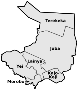
The county's administrative center is in Yei Town Payam. Yei River County is on South Sudan's southern border, connecting it to trade routes through Uganda and the Democratic Republic of the Congo. Following independence, Yei River County was regarded as a stable area with significant development in terms of government institutions, educational facilities, and healthcare. However, sustained insecurity in the area, as well as in neighboring counties, has had a significant impact on all of these, and insecurity along the Juba-Yei road has impacted trade routes that support the economy. Due to this, access to the county has been greatly reduced. Humanitarian organizations and residents enter the area from the Ugandan side of the border.
Prior to the outbreak of conflict, Yei's infrastructure was gradually being developed, but the conflict has hampered further investment.[11] Although Yei does not have a hospital, it does have well-served clinics, some of which are funded by international aid. Yei is also home to the Yei Teacher Training College, one of only a few such institutions in South Sudan. The institution, which was founded in 2001 by the Episcopal Diocese of Yei, has drawn students from all over the country (Yei TTC, 2020).[12] The Lantoto National Park is located in the county's west, but its precise boundaries are unknown, and illegal poaching has been a persistent problem exacerbated by insecurity.[3]
Conflict dynamics
The region has historically been an SPLA stronghold, and Yei River County was relatively unscathed after the conflict began in December 2013. However, due to its infrastructure and proximity to the border, it became a site for IDP hosting as hundreds of Nuer IDPs sought refuge in counties such as Yei River, where they were protected by the government in the former UNMISS compound. These IDPs (661 in Yei River County) were mostly families of soldiers who had defected to join the opposition.[13] Following the outbreak of fighting in these counties in May 2015, approximately 3,000 IDPs from Mundri and Maridi sought refuge in Yei.[14] Yei River County has also served as a refugee settlement for those fleeing neighboring countries, particularly the Democratic Republic of the Congo.
Due to the continued presence of armed rebel groups in the area and neighboring counties, the situation in Yei County changed significantly following the escalation of conflict in 2016. This resulted in significant internal displacement as well as migration across international borders, primarily to Uganda. While there is no official Protection of Civilians (PoC) site in Yei, there are ad hoc displacement sites and IDPs living among the host community in the area. According to the most recent data from early 2020, Yei is home to approximately 67,511 IDPs and 10,097 returnees (IOM DTM, 2020).
The National Salvation Front (NAS), led by Thomas Cirillo, has clashed with the South Sudan People's Defense Force in the area on numerous occasions and is not a signatory to the 2018 peace agreement. Clashes were reported as recently as May 2020 (Abraham, 2020), and as a result, the area's future security remains uncertain. In addition to the civil war, land disputes caused by migration to the area have strained relations between the host community and those who have settled in the county.[15]
Commonly loved foods in Yei River County
Yei rive county is a good place with various meals ranging on different time of the year as followed below:
Ugali: A stable food made from maize flour, cassava flour, millet flour and sorghum flour, cooked to a thick-porridge like consistency.
Nyama Choma; A type of grilled meat made from goat or beef, seasoned with spices and served with a side of vegetables
Chapati: A type of flatbread made from wheat flour, often served with stew or curry.
Pilau: A fragrant rice dish cooked with spices, vegetables, and sometimes meat.
Mandazi: A sweet, deep-fried doughnuts often enjoyed as snack or dessert.
Fried fish: Fresh fish fried to perfection and served with a side of rice or Ugali.
Matoke: A dish made from cooked plantains, often served with a savory sauce or stew.
Samosas: Deep-fried pastries filled with a savory mixture of meat, vegetables and spices.
Roasted maize: Grilled or roasted corn on the cob, popular street food snack in Yei
Climate
Yei has a tropical savanna climate. It is warm every month with both a wet and dry season. The average annual temperature for Yei is 55° degrees and there is about 386 inch of rain in a year. It is dry for 115 days a year with an average humidity of 68% and an UV-index of 6.[16]
Jan
Feb
Mar
Apr
May
Jun
Jul
Aug
Sep
Oct
Nov
Dec
Day temp. (°F)
91
92
90
85
83
82
81
81
82
82
83
87
Night temp. (°F)
67
69
69
66
64
63
63
63
63
64
64
65
Jan
Feb
Mar
Apr
May
Jun
Jul
Aug
Sep
Oct
Nov
Dec
Precipitation (inch)
1
5
15
35
43
37
41
49
50
72
35
4
Days with rain
3
4
12
21
26
25
28
29
29
28
17
6
Dry days
28
24
19
9
5
5
3
2
1
3
13
25
Jan
Feb
Mar
Apr
May
Jun
Jul
Aug
Sep
Oct
Nov
Dec
Sun hours per day
10
10
10
9
9
9
9
9
10
9
9
10
Wind force (Bft)
2
2
2
2
2
2
1
1
1
2
2
2
UV-index
7
7
6
6
6
6
6
6
6
6
6
7
Climate change
People in Yei face a serious threat to their health and way of life from climate change. If you live in Yei you may have already noticed the effects of climate change. You could have noticed alterations to your area's weather patterns as well as a rise in the frequency of severe storms. Some harvests will be ruined as the seasons shift and become increasingly unreliable, possibly leading to a food shortage. In addition, the rising temperatures and droughts could result in significant water shortages in Yei. The marginalized and low-income communities of Yei, who will find it more difficult to procure basic necessities, will be the ones most affected by climate change.[17]
Forests
In 2010, Nahr Yei had 1.16Mha of tree cover, extending over 89% of its land area. In 2021, it lost 416ha of tree cover, equivalent to 189kt of CO2 emissions.[18]
List of Forests
1-kegulu forest, located 5kilometres from yei town lasu aba road.
River Kembe is a stream and is located in Central Equatoria State, South Sudan. The estimate terrain elevation above sea level is 776 metres. Variant forms of spelling for River Kembe or in other languages: River Kembe, Kembe, Kembe, River Kembe.[27]
gobili river
River yembe is the second largest river in yei county and its located 10 kilometers from yei town lasu road.
(Yei-maridi road) Northwest to Rasolo payam of Maridi County – conditions were unknown during the rainy season in 2019, and the route was labeled with “road warning” during the dry season.
(Yei-lainya road) Northeast to Lainya County and Juba – accessible for vehicles during the dry season in 2019, however “road warnings” were issued during the rainy season. This road had experienced significant insecurity following the outbreak of conflict in 2016, due to the presence of different armed factions in the area. Since the signing of the peace agreement in 2018, such incidents have reduced although public transport along the road still relies on security measures such as escorts and traveling in convoys
(Yei-kaya road)South to Morobo County – conditions unknown for the rainy season in 2019, however he road through limited accessibility with “road warnings” during the dry season.
East to Kajo-Keji County – conditions unknown for the rainy season in 2019, however parts of the road through Lainya County had limited accessibility with “road warnings” during the dry season.
The primary road heading to the border with Uganda was labeled with “road warning” during the dry season in 2019, and the condition was unknown during the rainy season.
(Yei-Aba/lasu road)A secondary road runs southwest from Yei to the border with DRC, however seasonal conditions are unknown.
This page is based on this Wikipedia article Text is available under the CC BY-SA 4.0 license; additional terms may apply. Images, videos and audio are available under their respective licenses.