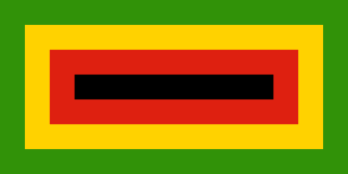
Manicaland is a province in eastern Zimbabwe. After Harare Province, it is the country's second-most populous province, with a population of 2.037 million, as of the 2022 census. Making it the third most densely populated province after Harare and Bulawayo provinces. Manicaland was one of five original provinces established in Southern Rhodesia in the early colonial period. The province endowed with country's major tourist attractions, the likes of Mutarazi Falls, Nyanga National Park and Zimbabwe's top three highest peaks. The province is divided into ten administrative subdivisions of seven rural districts and three towns/councils, including the provincial capital, Mutare. The name Manicaland is derived from one of the province's largest ethnic groups, the Manyika, who originate from the area north of the Manicaland province and as well as western Mozambique, who speak a distinct language called ChiManyika in Shona.

Ndabaningi Sithole was a Zimbabwean politician and statesman who was the founder of the Zimbabwe African National Union (ZANU), a militant, nationalist organisation that opposed the government of Rhodesia, in July 1963. He worked as a United Church of Christ in Zimbabwe (UCCZ) minister. He spent 10 years in prison after the government banned ZANU. A rift along tribal lines split ZANU in 1975, and he lost the 1980 elections to Robert Mugabe.
Chipinge District is a district in Manicaland Province of eastern Zimbabwe. The administrative headquarters is Chipinge.

Birchenough Bridge is the name for both a bridge across the Save River and a village next to the bridge. Birchenough Bridge is called after Sir Henry Birchenough. Birchenough Bridge is located 62 km from Chipinge in the Manicaland province of Zimbabwe linking Chipinge with Buhera.

Zimbabwe African National Union – Ndonga is a minor political party in Zimbabwe. Its members were originally part of Zimbabwe African National Union, but split with what would become ZANU–PF over tribal tensions. A portion of the party reunified with ZANU-PF in 2015.
The Ndau are an ethnic group. The name "Ndau" means Land. Just like the Manyika people in northern Manicaland, their name Manyika also meaning "Owners of the Land", the name Ndau means Land. E.g "Ndau yedu" meaning "our land" When the Ngoni observed this, they called them the Ndau people, the name itself meaning the land, the place or the country in their language. A traditional outsider suggestion is that the name is derived from the Nguni words "Amading'indawo" which means "those looking for a place" as this is what the Gaza Nguni called them and the name then evolved to Ndau. However, they are described in detail to have already been occupying parts of Zimbabwe and Mozambique in 1500s by the Portuguese missionary Joao dos Santos. The five largest Ndau groups are the Magova; the Mashanga; the Vatomboti, the Madanda and the Teve. Ancient Ndau People met with the Khoi/San during the first trade with the Arabs at Mapungumbwe and its attributed to the Kalanga, Venda, Shona, and Ndau peoples. They traded with Arabs with "Mpalu", "Njeti" and "Vukotlo" these are the red, white and blue coloured cloths together with golden beads. Ndau people traded traditional herbs, spiritual powers, animal skins and bones.

Buhera District is a district in Manicaland Province, in eastern Zimbabwe.
Wilson Khumbula, also known as Kujokochera, is a Zimbabwean politician and businessman. He is a former leader of the Zimbabwe African National Union - Ndonga (ZANU-Ndonga), and arguably dissolved the faction in 2015, 2018, and 2021 to join ZANU-PF. He was one of the early members of ZANU-Ndonga, which formed in 1963 under Ndabaningi Sithole.
Learnmore "Judah" Jongwe was a Zimbabwean lawyer and politician who served as Member of the National Assembly of Zimbabwe for Kuwadzana, and spokesman for the Movement for Democratic Change. In August 2002 he was charged with the murder of his wife, Rutendo Muusha, after he had surrendered to the police, he was then put in custody awaiting trial before he died soon after.

Mwenezi, originally known as Nuanetsi, is a small district situated in southern Zimbabwe. It is bisected by the Mwenezi River and the A4 highway, the main thoroughfare that connects the town of Beitbridge, on the border with South Africa, to Masvingo.
Chipinge, formerly known as Chipinga, is a town in Zimbabwe, located in Chipinge District, in Manicaland Province, in southeastern Zimbabwe, close to the border with Mozambique.
Muller Conrad 'Billy' Rautenbach is a Zimbabwean businessman whose ventures include companies that are involved in transport, cobalt, platinum mining, and biofuel production, primarily in Africa. He was born on 23 September 1959, in Salisbury. The 2022 Data Leaks at Credit Suisse appears to confirm allegations, for which he had faced American and European sanctions in earlier years that Rautenbach used the proceeds from a mining deal to support the ZANU-PF regime of dictator Robert Mugabe, during the latter's repressive 2008 election campaign in Zimbabwe. From 1999 to 2009, Rautenbach was a fugitive of fraud and corruption charges in South Africa.
Energy in Zimbabwe is a serious problem for the country. Extensive use of firewood leads to deforestation and the electricity production capacity is too low for the current level of consumption.

Mvurachena Primary School is a Christian, independent, co-educational school in Chipinge, Zimbabwe.

Cecil was a male African lion who lived primarily in the Hwange National Park in Matabeleland North, Zimbabwe. He was being studied and tracked by a research team of the University of Oxford as part of a long-term study.

Zimbabwe experienced severe floods from December 2016 through March 2017 due to heavy rains that followed a two-year drought.
Edline Mutumbami is a Zimbabwean footballer who plays as a defender for Blue Swallows FC and the Zimbabwe women's national team.


