

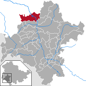
Gumpelstadt is a village of the Moorgrund municipality in the Wartburgkreis district in Thuringia, Germany (since 1994).
Gumpelstadt is a village of the Moorgrund municipality in the Wartburgkreis district in Thuringia, Germany (since 1994).
Gumpelstadt is located at an altitude of about 280 meters on the southwest edge of the Thuringian Forest and about five kilometers northeast of Bad Salzungen.
Gumpelstadt was first mentioned in 1155. It was first a territory of the Fulda monastery. In 1346 it was take over by the House of Wettin.
Between 1629 and 1664 there were witch trials held in Gumpelstadt in which a woman and a man were burned to death and a woman died under torture. [1]
In 1680, with the fracturing of the Ernestine duchies, Gumpelstadt became part of the Principality of Saxe-Meiningen. It was first part of Amt Altenstein, in 1868 it became part of Meiningen county and in 1950 part of Bad Salzungen county. In 1955, Gumpelstadt had 1223 inhabitants. [2]
Historic industries in the village were agriculture and livestock, and later mining and textile industry.
On 25 March 1994, the municipalities Gumpelstadt, Waldfisch and Witzelroda were dissolved and merged to form the new community Moorgrund. [3]

Gumpelstadt is home to 2 nature reserves, Jachzenthal and the mountain Alte Warth, both designated on 6 April 1995.
Hildburghausen is a district in Thuringia, Germany. It is bounded by the district of Schmalkalden-Meiningen, the city of Suhl, the districts of Ilm-Kreis, Saalfeld-Rudolstadt and Sonneberg, and the state of Bavaria. Located roughly halfway between the mountain chains of the Rhön and the Thuringian Forest, the district is densely forested and covered by hilly countryside. Its territory is similar to that of the former Ernestine duchy, Saxe-Hildburghausen.
Ilm-Kreis is a district in Thuringia, Germany. It is bounded by the city of Erfurt, the districts of Weimarer Land, Saalfeld-Rudolstadt and Hildburghausen, the city of Suhl, and the districts of Schmalkalden-Meiningen and Gotha. It is named after the river Ilm, flowing through the district.

Suhl is a city in Thuringia, Germany, located SW of Erfurt, 110 kilometres NE of Würzburg and 130 kilometres N of Nuremberg. With its 37,000 inhabitants, it is the smallest of the six urban districts within Thuringia. Together with its northern neighbour-town Zella-Mehlis, Suhl forms the largest urban area in the Thuringian Forest with a population of 46,000. The region around Suhl is marked by up to 1,000-meter-high mountains, including Thuringia's highest peak, the Großer Beerberg, approximately 5 kilometres NE of the city centre.
Schmalkalden-Meiningen is a Landkreis in the southwest of Thuringia, Germany. Its neighboring districts are the districts Wartburgkreis, Gotha, Ilm-Kreis, the district-free city Suhl, the district Hildburghausen, the Bavarian district Rhön-Grabfeld, and the district Fulda in Hesse.
Wartburgkreis is a Kreis (district) in the west of Thuringia, Germany. Neighboring districts are the districts Unstrut-Hainich-Kreis, Gotha, Schmalkalden-Meiningen, and the districts Fulda, Hersfeld-Rotenburg and Werra-Meißner-Kreis in Hesse.

Schloss Altenstein is a schloss, or palace, upon a rocky hill on the south-western slope of the Thuringian Forest, not far from Eisenach, Thuringia, Germany. It was the summer residence of the Dukes of Saxe-Meiningen, and is surrounded by 160 hectares of English landscape garden, which contain, among other objects of interest, a cavern 300 metres long, through which flows a large and rapid stream.

Bad Salzungen is a town in Thuringia, Germany. It is the capital of the Wartburgkreis district.
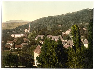
Bad Liebenstein is a municipality and spa town in Wartburgkreis district of Thuringia, Germany.

Kaltennordheim is a town in the Schmalkalden-Meiningen district, in Thuringia, Germany. It is situated in the Rhön Mountains, 22 km southwest of Bad Salzungen, and 35 km east of Fulda. The former municipalities Aschenhausen, Kaltensundheim, Kaltenwestheim, Melpers, Oberkatz und Unterweid were merged into Kaltennordheim in January 2019. At the same time, Kaltennordheim passed from the Wartburgkreis to Schmalkalden-Meiningen.

Steinbach-Hallenberg is a town in the Schmalkalden-Meiningen district, in Thuringia, Germany. It is situated in the Thuringian Forest, 8 km east of Schmalkalden, and 13 km northwest of Suhl. The former municipalities Altersbach, Bermbach, Oberschönau, Unterschönau, Rotterode and Viernau were merged into Steinbach-Hallenberg in January 2019.

Barchfeld is a village and a former municipality in the Wartburgkreis district of Thuringia, Germany. Since 31 December 2012, it is part of the municipality Barchfeld-Immelborn.
Merkers-Kieselbach is a former municipality in the Wartburgkreis district of Thuringia, Germany. Since 31 December 2013, it is part of the municipality Krayenberggemeinde.
Breitungen is a municipality in the Schmalkalden-Meiningen district, Thuringia, Germany. It is situated on the river Werra, southeast of Bad Salzungen.
Leitenhausen was a village in Germany, founded in 1317 A D. It was part of the former municipality Gompertshausen. It was destroyed by the East German authorities in 1972 as it stood too close to the Inner German border, the border between the post-war states of East and West Germany. It lay in the extreme south of Thuringia in Heldburger Land in the district of Hildburghausen, only a few hundred metres away from the Thuringian-Bavarian border.

The Pleß is a mountain, 645.4 m above sea level (NHN), in the county of Schmalkalden-Meiningen in the Salzungen Werra Highland in the German state of Thuringia.
Ferdinand Jung was a German Communist activist who resisted the Nazi government in the 1930s and spent a good deal of time in prisons and concentration camps. In later life he found himself in the political mainstream in his country's second one-party dictatorship and became a senior politician.

The Salzungen Werra Upland is a natural region in Germany that forms part of the East Hesse Highlands in the German states of Hesse and Thuringia.

Süd-Thüringen-Bahn GmbH (STB) is a public, non-state-owned railway company founded on 10 December 1999. The shareholders are Erfurter Bahn GmbH (EB) and Hessische Landesbahn GmbH (HLB), each with a 50 percent stake. The company is based at Erfurter Bahn in Erfurt, Thuringia. The operating location and operational management are located in Meiningen, Thuringia.
Wartburgkreis I is an electoral constituency represented in the Landtag of Thuringia. It elects one member via first-past-the-post voting. Under the current constituency numbering system, it is designated as constituency 5. It covers the southern part of Wartburgkreis and a small area of Schmalkalden-Meiningen.
Olaf Koch was a German conductor and Hochschullehrer.