This article talks about transportation in the Bahamas, a North American archipelagic state in the Atlantic Ocean.
Grand Turk Island is an island in the Turks and Caicos Islands. It is the largest island in the Turks Islands with 18 km2 (6.9 sq mi). Grand Turk contains the territory's capital, Cockburn Town and the JAGS McCartney International Airport. The island is the administrative, historic, cultural and financial center of the territory, and has the second largest population of the islands at approximately 3,720 people.

The Abaco Islands lie in the northern Bahamas 180 miles (290 km) east of South Florida. They comprise the main islands of Great Abaco and Little Abaco, along with smaller barrier cays. The northernmost are Walker's Cay, and its sister island Grand Cay. To the south, the next inhabited islands are Spanish Cay and Green Turtle Cay, with its settlement of New Plymouth, Great Guana Cay, private Scotland Cay, Man-O-War Cay, and Elbow Cay, with its settlement of Hope Town. Southernmost are Tilloo Cay and Lubbers Quarters. Another of note off Abaco's western shore is onetime Gorda Cay, now a Disney Island and cruise ship stop and renamed Castaway Cay. Also in the vicinity is Moore's Island. On the Big Island of Abaco is Marsh Harbour, the Abacos' commercial hub and the Bahamas' third largest city, plus the resort area of Treasure Cay. Both have airports. A few mainland settlements of significance are Coopers Town and Fox Town in the north and Cherokee and Sandy Point in the south. Administratively, the Abaco Islands constitute seven of the 31 Local Government Districts of the Bahamas: Grand Cay, North Abaco, Green Turtle Cay, Central Abaco, South Abaco, Moore's Island, and Hope Town.

Ragged Island is a small island and district in the southern Bahamas. Ragged Island is part of the Jumentos Cays and Ragged Island Chain. The crescent-shaped chain measures over 110 miles (180 km) in length and includes cays known as Raccoon Cay, Hog Cay and Double-Breasted Cay. On 8 September 2017, Duncan Town took a direct hit from Hurricane Irma.

Elbow Cay is an eight-mile-long (13-kilometre) cay in the Abaco Islands of the Bahamas. Originally populated by British loyalists fleeing the newly independent United States of America in 1785, it has survived on fishing, boat building, and salvage. Its main village of Hope Town surrounds a protected harbor with a noted red-and-white-striped one-hundred-and-twenty-foot-tall (37-metre) lighthouse built in 1863.

Great Isaac Cay is a small Bahamian island located about 20 miles (32 km) NNE of the Bimini Islands. It is accessible only by boat.

Hope Town is one of the districts of the Bahamas, on the Abaco islands as well as a small village on Elbow Cay, located in Abaco. The area had a population of 458 in 2010.

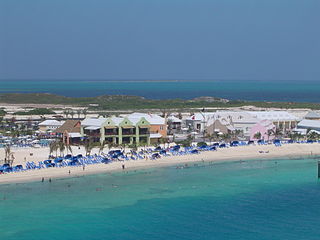
Great Stirrup Cay is a 268-acre (108 ha) island that is part of the Berry Islands in the Bahamas. Norwegian Cruise Line purchased the island from the Belcher Oil Company in 1977 and developed it into a private island for their cruise ship passengers. The northern part of the island has a sandy beach surrounded by rocks with snorkeling areas. The southern part features a helicopter airfield, a large area without vegetation, and numerous concrete blocks. These are all remnants of a previous U.S. military installation and satellite tracking station. The island's lighthouse was originally constructed in 1863 by the Imperial Lighthouse Service. Great Stirrup Cay is adjacent to Little Stirrup Cay, Royal Caribbean Cruises' private island.

Cay Sal Bank is the third largest and the westernmost of the Bahama Banks. It is located between 23º27'N - 24º10'N and 079º25'W – 080º35'W. In a geographical sense, it is separate from the Bahamas proper as it is much closer to Cuba than to the closest Bahamanian island. It is separated by Santaren Channel from the Great Bahama Bank, the western rim of which is 50 km (31 mi) to the east. The Straits of Florida separate it from the United States mainland and the Florida Keys.
The Cat Cays are two islands in the Bahamas, North Cat Cay and South Cat Cay, approximately 10 miles (16 km) south of Bimini. North Cat Cay is a privately owned island and is run as a private members club by the Cat Cay Yacht Club. South Cat Cay is currently under development.

The following outline is provided as an overview of and topical guide to the Bahamas:

The following is an alphabetical list of topics related to the Commonwealth of the Bahamas.

The Exuma Cays Land and Sea Park is a protected area in the Exuma Cays of the Bahamas. The protected area extends from Shroud Cay in the north to Bell Cay in the south. The vegetation consists of mangrove communities, with the east sides being clad in low scrub and the western sides with taller scrub. There are many epiphytic orchids and bromeliads.
Joulter Cays are small uninhabited islands to the north of Andros Island in the Bahamas. Oolitic sand dominates the intertidal zone around the small islands that are covered with vegetation.
Cay Sal is a small island in the Cay Sal Bank between Florida, Cuba, and the Bahamas. It is no longer inhabited.

The Conception Island National Park is a protected area in the Bahamas. The island lies between Cat Cays to the north and Rum Cay to the south. The vegetation consists of mangrove communities, with typical strand vegetation, and the island is visited by green turtles, sea birds and migrating birds.

The Elbow Cays are uninhabited cays in the Cay Sal Bank, Bahamas. They are part of a reef shelf located at the northwestern end of the bank about 80 km off the Cuban coast and 130 km southeast of Key West, Florida. These cays are an excellent scuba diving spot.
Pelican Cays Land and Sea Park is a national park in Central Abaco, the Abaco Islands, the Bahamas. The park was established in 1972 and has an area of 2,100 acres (8 km2). The park's marine environment contains an extensive coral reef and undersea cave habitat, which provide opportunities for snorkelling and underwater diving.
Tilloo Cay National Reserve is a national park in Hope Town, the Abaco Islands, the Bahamas. The reserve was established in 1990 and has an area of 11 acres (4 ha).

