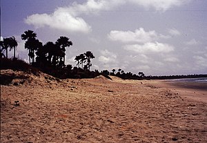
Senegal is a coastal West African nation located 14 degrees north of the equator and 14 degrees west of the Prime Meridian. The country's total area is 196,190 km2 of which 192,000 km2 is land and 4,190 km2 is water.
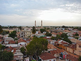
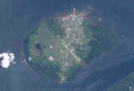
Banjul, officially the City of Banjul, is the capital and fourth largest city of The Gambia. It is the centre of the eponymous administrative division which is home to an estimated 400,000 residents, making it The Gambia's largest and most densely populated metropolitan area. Banjul is on St Mary's Island, where the Gambia River enters the Atlantic Ocean. The population of the city proper is 31,301, with the Greater Banjul Area, which includes the City of Banjul and the Kanifing Municipal Council, at a population of 413,397. The island is connected to the mainland to the west and the rest of Greater Banjul Area via bridges. There are also ferries linking Banjul to the mainland at the other side of the river.

The Gambia is a very small and narrow African country with the border based on the Gambia River. The country is less than 48 km wide at its greatest width. The country's present boundaries were defined in 1889 after an agreement between the United Kingdom and France. It is often claimed by Gambians that the distance of the borders from the Gambia River corresponds to the area that British naval cannon of the time could reach from the river's channel. However, there is no historical evidence to support the story, and the border was actually delineated using careful surveying methods by the Franco-British boundary commission. Apart from its coastline, where the Gambia borders the Atlantic Ocean, it is almost an enclave of Senegal and is by far the smallest country on mainland Africa.

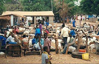
Basse Santa Su, usually known as Basse, is a town in the Gambia, lying on the south bank of the River Gambia. The easternmost major town in the nation, it is the capital of the Upper River Region and is known for its important market. As of 2009 it has an estimated population of 18,414. The history of the town dates back to the founding of Kabakama, now a neighborhood, in the mid 13th century by the Mandinka army of Tiramakhan Traore, who was ultimately buried there, expanding the Mali Empire west.
Daru is the capital of the Western Province of Papua New Guinea and a former Catholic bishopric. Daru town falls under the jurisdiction of Daru Urban LLG.

Lethem is a town in Guyana, located in the Upper Takutu-Upper Essequibo region. It is the regional capital of Upper Takutu-Upper Essequibo.

Kadayanallur is the largest city in Tenkasi district, Tamil Nadu, India. Kadayanallur is 18 km from Tenkasi.

Tumpat is a district (jajahan) in Kelantan, Malaysia. Tumpat is situated at the end of the East Coast Line railway line operated by Keretapi Tanah Melayu which links Kelantan to the western part of Peninsular Malaysia. This strategic location makes it the transportation hub of Kelantan. Tumpat town is approximately 15 km from the state capital, Kota Bharu.

Onslow is a coastal town in the Pilbara region of Western Australia, 1,386 kilometres (861 mi) north of Perth. It has a population of 848 people and is located within the Shire of Ashburton local government area.

Drought in Australia is defined by the Australian Bureau of Meteorology as rainfall over a three-month period being in the lowest decile of what has been recorded for that region in the past. This definition takes into account that drought is a relative term and rainfall deficiencies need to be compared to typical rainfall patterns including seasonal variations. Specifically, drought in Australia is defined in relation to a rainfall deficiency of pastoral leases and is determined by decile analysis applied to a certain area. Note that this definition uses rainfall only because long-term records are widely available across most of Australia. However, it does not take into account other variables that might be important for establishing surface water balance, such as evaporation and condensation.

Chandgad is a Small city and tehsil headquarters of chandgad taluka, of Kolhapur district that is in the Indian state of Maharashtra.
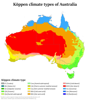
Australia's climate is governed mostly by its size and by the hot, sinking air of the subtropical high pressure belt. This moves north-west and north-east with the seasons. The climate is variable, with frequent droughts lasting several seasons, thought to be caused in part by the El Niño-Southern Oscillation. Australia has a wide variety of climates due to its large geographical size. The largest part of Australia is desert or semi-arid. Only the south-east and south-west corners have a temperate climate and moderately fertile soil. The northern part of the country has a tropical climate, varying between grasslands and desert. Australia holds many heat-related records: the continent has the hottest extended region year-round, the areas with the hottest summer climate, and the highest sunshine duration.
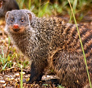
The wildlife of Senegal consists of the flora and fauna of this nation in West Africa. Senegal has a long Atlantic coastline and a range of habitat types, with a corresponding diversity of plants and animals. Senegal has 188 species of mammals and 674 species of bird.
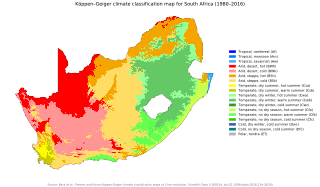
The climate of South Africa is determined by South Africa's situation between 22°S and 35°S, in the Southern Hemisphere's subtropical zone, and its location between two oceans, Atlantic and the Indian.
Abuko is a town in the West Coast Division of the Gambia, five miles southwest of the capital Banjul. It is located in the district of Kombo North/Saint Mary to the north of Banjul International Airport and Abuko Nature Reserve.

Kartung or Kartong is a coastal village in south-western Gambia on the border with Senegal. It is located approximately 60 kilometres from Banjul and 9.5 kilometres from Gunjur. It is located in Kombo South District in the Western Division. As of 2009, it has an estimated population of 5213.
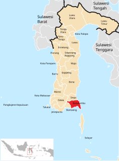
Bulukumba Regency is a regency in the southeast corner of South Sulawesi Province, Indonesia. It covers an area of 1,154.58 km2, and had a population of 394,757 at the 2010 Census and 437,607 at the 2020 Census. The town of Bulukumba is its capital.
The 2009 West Africa floods are a natural disaster that began in June 2009 as a consequence of exceptionally heavy seasonal rainfall in large areas of West Africa. Several rivers, including the Pendjari, Niger, Volta and Senegal rivers, broke their banks, causing destruction of houses, bridges, roads and crops. The floods are reported to have affected 940,000 people across 12 countries, including Burkina Faso, Benin, Ghana, Niger, Senegal, Guinea, and caused the deaths of at least 193 people. In Burkina Faso, one of the most affected countries, 150,000 people fled their homes, mostly in the capital Ouagadougou where rainfall in one day was equal to 25% of normal annual rainfall for the whole country.

Cotagaita is a small town in Bolivia. In 2009 it had an estimated population of 1904.