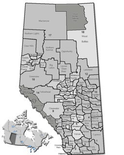
Division No. 12 is a census division in Alberta, Canada. Including the City of Cold Lake, the majority of the division is located in the northeast corner of central Alberta, while the northern portion of the division is located within northern Alberta.

The Pembina River is a tributary of the Athabasca River in central Alberta, Canada.

Beaver Crossing is a hamlet in central Alberta, Canada within the Municipal District of Bonnyville No. 87, located on Highway 28 where it crosses the Beaver River, approximately 12 kilometres (7.5 mi) south of Cold Lake. Near here was Cold Lake House built by the Montreal traders in 1781.

Beaverdam is a hamlet in central Alberta, Canada, within the Municipal District of Bonnyville No. 87, located approximately 16 kilometres (9.9 mi) south of Highway 28 and 30 kilometres (19 mi) southwest of Cold Lake.

Bellis is a hamlet in central Alberta, Canada within Smoky Lake County. Previously an incorporated municipality, Bellis dissolved from village status on January 1, 1946 to become part of the Municipal District of Vilna No. 575.

Edwand is a hamlet in central Alberta, Canada within Smoky Lake County. It is located 4 kilometres (2.5 mi) north of Highway 28, approximately 104 kilometres (65 mi) northeast of Edmonton.

Fabyan is a hamlet in central Alberta, Canada within the Municipal District of Wainwright No. 61. It is located on Highway 14, approximately 10 kilometres (6.2 mi) west of Wainwright, Alberta, and 78 kilometres (48 mi) southwest of Lloydminster. It is located near the Fabyan Trestle Bridge.

Fenn is an unincorporated community in central Alberta in the County of Stettler No. 6, located 1 kilometre (0.62 mi) west of Highway 56, 73 kilometres (45 mi) east of Red Deer.

Fort Kent is a hamlet in central Alberta, Canada within the Municipal District of Bonnyville No. 87, located on Highway 28 approximately 32 kilometres (20 mi) southwest of Cold Lake.

Hilda is a hamlet in southern Alberta, Canada within Cypress County, located 4 kilometres (2.5 mi) east of Highway 41, approximately 67 kilometres (42 mi) northeast of Medicine Hat. In 1910, the post master named the post office "Hilda" after his infant daughter.

Hylo is a hamlet in northern Alberta, Canada within Lac La Biche County. It is located approximately 16 kilometres (9.9 mi) south of Highway 55 and 133 kilometres (83 mi) west of Cold Lake.

La Corey is a hamlet in central Alberta, Canada within the Municipal District of Bonnyville No. 87, located on Highway 55 approximately 38 kilometres (24 mi) west of Cold Lake.

Long Lake is a hamlet in central Alberta, Canada within Thorhild County. It is located on the west shore of Long Lake, approximately 12 kilometres (7.5 mi) east of Highway 63 and 114 kilometres (71 mi) northeast of Edmonton.

Lottie Lake is a hamlet in northern Alberta, Canada within the County of St. Paul No. 19. It is located 1 kilometre (0.62 mi) west of Highway 36, approximately 138 kilometres (86 mi) northeast of Edmonton.

Spedden is a hamlet in central Alberta, Canada within Smoky Lake County. It is located 0.3 kilometres (0.19 mi) north of Highway 36, approximately 106 kilometres (66 mi) southwest of Cold Lake. It was named after one of the original surveyors who died in the area in 1919. Previously it was Cache Lake.

St. Vincent is a hamlet in northern Alberta, Canada within the County of St. Paul No. 19. It is located 3 kilometres (1.9 mi) south of Highway 28, approximately 79 kilometres (49 mi) southwest of Cold Lake.

Therien is a hamlet in central Alberta, Canada within the Municipal District of Bonnyville No. 87, located approximately 7 kilometres (4.3 mi) north of Highway 28 and 74 kilometres (46 mi) southwest of Cold Lake.

Thunder Lake is a hamlet in central Alberta within the County of Barrhead No. 11. It is located on the eastern shore of Thunder Lake, just south of Thunder Lake Provincial Park, and is about 5 kilometres (3.1 mi) west of Highway 18 and approximately 21 kilometres (13 mi) west of Barrhead.

Tulliby Lake is a hamlet in central Alberta, Canada within the County of Vermilion River. It is located approximately 23 kilometres (14 mi) north of Highway 45 and 50 kilometres (31 mi) northwest of Lloydminster.

Venice is a hamlet in northern Alberta, Canada within Lac La Biche County. It is located approximately 11 kilometres (6.8 mi) west of Highway 55 and 130 kilometres (81 mi) northwest of Cold Lake.


