
Anuradhapura is a major city located in the north central plain of Sri Lanka. It is the capital city of North Central Province and the capital of Anuradhapura District. The city lies 205 kilometers (127 mi) north of the current capital of Colombo in the North Central Province, on the banks of the historic Malwathu Oya. The city is now a World Heritage Site famous for its well-preserved ruins of the ancient Sinhalese civilisation.

Kandy is a major city located in the Central Province of Sri Lanka. It was the last capital of the Sinhalese monarchy from 1469 to 1818, under the Kingdom of Kandy. The city is situated in the midst of hills in the Kandy plateau, which crosses an area of tropical plantations, mainly tea. Kandy is both an administrative and religious city and the capital of the Central Province. Kandy is the home of the Temple of the Tooth Relic, one of the most sacred places of worship in the Buddhist world. It was declared a World Heritage Site by UNESCO in 1988. Historically the local Buddhist rulers resisted Portuguese, Dutch, and British colonial expansion and occupation.
The Palk Strait is a strait between the Tamil Nadu state of India and the Jaffna District of the Northern Province of the island nation of Sri Lanka. It connects the Bay of Bengal in the northeast with Palk Bay in the southwest. It is 40 to 85 miles wide and 85 miles long. Several rivers flow into it, including the Vaigai River of Tamil Nadu. The strait is named after Robert Palk, who was a governor of Madras (1755–1763) during the Company Raj period.

Provinces are the first level administrative divisions of Sri Lanka. Currently, Sri Lanka is divided into 9 provinces. Each province is further divided into districts, which are further divided into divisional secretariats.

Hatton is a major town in the Nuwara Eliya District of Central Province, Sri Lanka governed by the Hatton-Dickoya Urban Council. Hatton is a major centre of the Sri Lankan tea industry.

Islam is the third largest religion in Sri Lanka, with about 9.7 percent of the total population following the religion. About 1.9 million Sri Lankans adhere to Islam as per the Sri Lanka census of 2012. The majority of Muslims in Sri Lanka are concentrated in the Eastern Province of the island. Other areas containing significant Muslim minorities include the Western, Northwestern, North Central, Central and Sabaragamuwa provinces. Muslims form a large segment of the urban population of Sri Lanka and are mostly concentrated in major cities and large towns in Sri Lanka, like Colombo. Most Sri Lankan Muslims primarily speak Tamil, though it is not uncommon for Sri Lankan Muslims to be fluent in Sinhalese. The Sri Lankan Malays speak the Sri Lankan Malay creole language in addition to Sinhalese and Tamil.

Batticaloa is a major city in the Eastern Province, Sri Lanka, and its former capital. It is the administrative capital of the Batticaloa District. The city is the seat of the Eastern University of Sri Lanka and is a major commercial centre. It is on the east coast, 111 kilometres (69 mi) south of Trincomalee, and is situated on an island. Pasikudah is a popular tourist destination situated 35 km (22 mi) northwest with beaches and flat year-round warm-water shallow-lagoons.
The Eastern Province is one of the nine provinces of Sri Lanka, the first level administrative division of the country. The provinces have existed since the 19th century but did not have any legal status until 1987 when the 13th Amendment to the Constitution of Sri Lanka established provincial councils. Between 1988 and 2006 the province was temporarily merged with the Northern Province to form the North Eastern Province. The capital of the province is Trincomalee. Kalmunai is the largest and most populous city of Eastern Province.

North Central Province is one of the nine provinces of Sri Lanka. The province has an area of 10,472 km2, making it the largest province by area, and a population of 1,266,663, making it the 3rd least populated province. The city of Anuradhapura is the capital of the province.

Badulla is the capital and the largest city of Uva Province situated in the central hills of Sri Lanka. It is the capital city of Uva Province and the Badulla District.

Nuwara Eliya District is a district in Central Province, Sri Lanka, centered on the tourist city of Nuwara Eliya.

Badulla District is a district in Uva Province, Sri Lanka. The entire land area of the Badulla district is 2,861 km2 (1,105 sq mi) and has a total population of 837,000. The district is bounded by the Kandy district to the North and by Nuwara Eliya and Matale districts to the West. The South-Eastern border creates with the districts of Rathnapura,Monaragala & Ampara. Mainly the economy of the district is based on agricultural farming and livestock.

Matara is a major city in Sri Lanka, on the southern coast of Southern Province. It is the second largest city in Southern Province. It is 160 km (99 mi) from Colombo. It is a major commercial hub, and it is the administrative capital and largest city of Matara District.
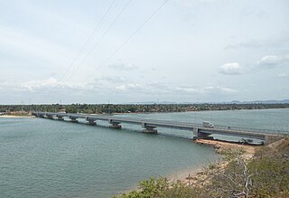
Kinniya is a town on the east coast of Sri Lanka, in the Trincomalee District of the Eastern Province. It is about 20 km (12 mi) from the city of Trincomalee and 240 km (150 mi) from Colombo. Located in Sri Lanka's dry zone, the Kinniya region often experiences hot and dry weather with very little precipitation. Kinniya Bridge is Sri Lanka's longest bridge, which attracts many tourists in the town. Being adjacent to the Trincomalee Harbour, Kinniya was devastated by the 2004 Indian Ocean tsunami.

The Central Province is one of the nine provinces of Sri Lanka. The province has an area of 5,674 km2 and a population of 2,421,148, making it the 2nd most populated province. The city of Kandy stands as its capital since 1469.

The Northern Province is one of the nine provinces of Sri Lanka. The province has an area of 8,884 km2, making it the 3rd largest province by area, and a population of 1,061,315, making it the least populated province. Jaffna is the capital city of the province.

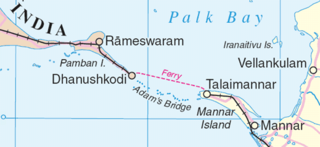
Mannar District is one of the 25 districts of Sri Lanka, the second level administrative division of the country. The district is administered by a District Secretariat headed by a District Secretary appointed by the central government of Sri Lanka. The capital of the district is Mannar, which is located on Mannar Island.

Katugastota is a suburb of the city of Kandy in Kandy District, Central Province of Sri Lanka. It is located along the Kandy-Jaffna A9 highway approximately 4 km (2.5 mi) from the city center of Kandy. Katugastota is one of the three main entry points to the city of kandy. Two major Highways meet at the center of the city which makes Katugastota one of the busiest suburbs in Kandy district.

The Norton Dam is the gravity dam built across the Kehelgamu Oya, which is a main tributary to the Kelani River. The dam is built at Norton Bridge, in the Central Province of Sri Lanka.
Adam's Bridge Marine National Park is a national park surrounding Adam's Bridge in northern Sri Lanka, approximately 30 km (19 mi) north west of Mannar.
