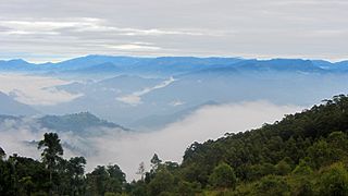
Gurulupota is a village located in Sri Lanka. It is situated in the Central Province, in the Matale District. The village is known for its scenic beauty, with lush greenery and rolling hills surrounding it. The people of Gurulupota are primarily engaged in agriculture, with tea, rubber, and spice cultivation being the main sources of income. The village is also home to a number of temples and other religious sites, which attract visitors from all over the country.
Location: Gurulupota is located about 18 kilometers away from the town of Matale, and can be reached by traveling along the Matale-Dambulla road.
Climate: The village enjoys a moderate climate, with temperatures ranging from 20°C to 28°C throughout the year. The rainy season in Gurulupota typically lasts from October to January.
Agriculture: Agriculture is the main source of income for the people of Gurulupota, and the village is known for its tea, rubber, and spice plantations. The fertile soil and favorable climate of the area make it ideal for cultivation.
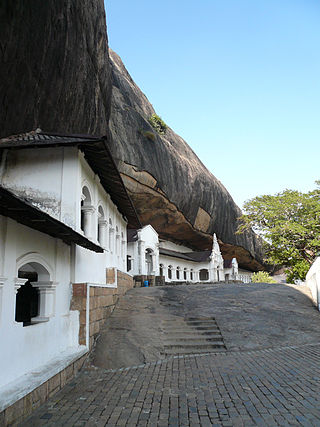
Religion: Gurulupota is home to a number of temples and religious sites, including the Sri Sudharshana Maha Viharaya and the Thalagala Sri Pabatharama Temple. These sites are of great cultural and religious significance to the local people.
Tourism: Gurulupota's natural beauty and religious sites make it a popular destination for tourists visiting Sri Lanka. Visitors can explore the tea and spice plantations, take a dip in the nearby waterfalls, and learn about the village's rich cultural heritage.
Cardamom, sometimes cardamon or cardamum, is a spice made from the seeds of several plants in the genera Elettaria and Amomum in the family Zingiberaceae. Both genera are native to the Indian subcontinent and Indonesia. They are recognized by their small seed pods: triangular in cross-section and spindle-shaped, with a thin, papery outer shell and small, black seeds; Elettaria pods are light green and smaller, while Amomum pods are larger and dark brown.
Kandy is a major city in Sri Lanka located in the Central Province. It was the last capital of the ancient kings' era of Sri Lanka. The city is situated in the midst of hills in the Kandy plateau, which crosses an area of tropical plantations, mainly tea. Kandy is both an administrative and religious city and is also the capital of the Central Province. Kandy is the home of the Temple of the Tooth Relic, one of the most sacred places of worship in the Buddhist world. It was declared a world heritage site by UNESCO in 1988. Historically the local Buddhist rulers resisted Portuguese, Dutch, and British colonial expansion and occupation.
Dambulla is a town situated in the north of Matale District, Central Province of Sri Lanka. It is the second largest populated and urbanised centre after Matale in the Matale District. It is situated 148 km (92 mi) north-east of Colombo, 43 km (27 mi) north of Matale and 72 km (45 mi) north of Kandy. Due to its location at a major junction, it is the centre of major vegetable distribution in the country.
Matale is the administrative capital city of the Matale District. It is the most urbanised and populated centre in the district. Matale is also the second largest municipal and urban centre in central province after Kandy. It is located at the heart of the central hills of the island and lies in a broad, fertile valley at an elevation of 364 m (1,194 ft) above sea level. Surrounding the city are the Knuckles Mountain Range, the foothills were called Wiltshire by the British. They have also called this place as Matelle.
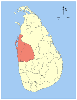
North Western Province is a province of Sri Lanka. The province consists of the districts of Kurunegala and Puttalam. Its capital is Kurunegala, which has a population of 28,571. The province is known mainly for its numerous coconut plantations. Other main towns in this province are Chilaw (24,712) and Puttalam (45,661), which are both small fishing towns. The majority of the population of Wayamba province is of Sinhalese ethnicity. There is also a substantial Sri Lankan Moor minority around Puttalam and Sri Lankan Tamils in Udappu and Munneswaram. Fishing, prawn farming and rubber tree plantations are other prominent industries of the region. The province has an area of 7,888 km2, and a population of 2,370,075.
Ratnapura is a major city in Sri Lanka. It is the capital city of Sabaragamuwa Province, as well as the Ratnapura District, and is a traditional centre for the Sri Lankan gem trade. It is located on the Kalu Ganga in south-central Sri Lanka, some 101 km (63 mi) southeast of the country's capital, Colombo. Ratnapura is also spelled as Rathnapura.
Indian Tamils of Sri Lanka are Tamil people of Indian origin in Sri Lanka. They are also known as Malayaga Tamilar, Hill Country Tamils, Up-Country Tamils or simply Indian Tamils. They are partly descended from workers sent from South India to Sri Lanka in the 19th and 20th centuries to work in coffee, tea and rubber plantations. Some also migrated on their own as merchants and as other service providers. These Tamil speakers mostly live in the central highlands, also known as the Malayakam or Hill Country yet others are also found in major urban areas and in the Northern Province. Although they are all termed as Tamils today, some have Telugu and Malayalee origins as well as diverse South Indian caste origins. They are instrumental in the plantation sector economy of Sri Lanka. In general, socio-economically their standard of living is below that of the national average and they are described as one of the poorest and most neglected groups in Sri Lanka. In 1964 a large percentage were repatriated to India, but left a considerable number as stateless people. By the 1990s most of these had been given Sri Lankan citizenship. Most are Hindus with a minority of Christians and Muslims amongst them. There are also a small minority followers of Buddhism among them. Politically they are supportive of trade union-based political parties that have supported most of the ruling coalitions since the 1980s.
Badulla District is a district in Uva Province, Sri Lanka. The entire land area of the Badulla district is 2,861 km2 (1,105 sq mi) and has a total population of 837,000. The district is bounded by the districts of Monaragala and Rathnapura on the east and south, by Ampara and Kandy districts to the north and by Nuwara Eliya and Matale to the west. Mainly the economy of the district is based on agricultural farming and livestock.
Pussellawa Sinhala: පුස්සැල්ලාව. Tamil: புசல்லாவ, is a l town in Kandy District, Sri Lanka. It is located along the A5 road between Gampola and Nuwara Eliya.
The primary form of agriculture in Sri Lanka is rice production. Rice is cultivated during Maha and Yala seasons. Tea is cultivated in the central highlands and is a major source of foreign exchange. Vegetables, fruits and oilseed crops are also cultivated in the country. There are two Agriculture Parks abbreviated as A. Parks established by the Department of Agriculture. Out of the total population in Sri Lanka, 27.1% engages in agricultural activities. Agriculture accounted for 7.4% of the GDP in 2020.
Agriculture in Indonesia is one of the key sectors within the Indonesian economy. In the last 50 years, the sector's share in national gross domestic product has decreased considerably, due to the rise of industrialisation and service sector. Nevertheless, for the majority of Indonesian households, farming and plantation remains as a vital income generator. In 2013, the agricultural sector contributed 14.43% to national GDP, a slight decline from 2003's contribution which was 15.19%. In 2012, the agricultural sector provides jobs to approximately 49 million Indonesians, representing 41% of the country's total labor force.
Bandarawela is the second largest town in the Badulla District which is 28 km (17 mi) away from Badulla. Bandarawela is 200 km (120 mi) away from Colombo and about 125 km (78 mi) away from Kandy, the two largest cities of Sri Lanka. Thanks to its higher altitude, compared to surrounding locations, Bandarawela has milder weather conditions throughout the year making it a tourist destination for locals. Bandarawela is within hours reach of surrounding towns and cities by both road and rail. The town is influenced by its colonial history and rests among dense, lush forestation occupying a niche among visitors as a base for eco-tourism.
The Central Province is one of the nine provinces of Sri Lanka, the first level administrative division of the country. The Central Province is primarily in the central mountainous terrain of Sri Lanka. It is the 6th largest province by area and is home to 2.5 million people. It is bordered by North Central Province to the north, Uva Province to the east, North Western Province to the west and Sabaragamuwa Province to the south and west. The province's capital is Kandy.
Gelioya is a town located in Udunuwara Divisional Secretariat, Kandy District, Central Province, Sri Lanka. It is situated approximately 14 kilometers east of Kandy, the district capital. Gelioya is a rapidly growing town, known for its scenic beauty, historical significance, and vibrant cultural heritage.
Deraniyagala is a town in the Kegalle district in the Sabaragamuwa Province of Sri Lanka. Deraniyaga city area consists major government administrative offices, textile industries and transportation hub and the district hospital which has seven medical officers including the DMO, Dr N.G.R.R.Senevirathne who upgraded this hospital into a good condition including the ETU with standard facilities. Deraniyagala divisional secretariat area includes 214.6 km2 and population of about 46300. The divisional secreatariate includes 26 grama niladari divisions.
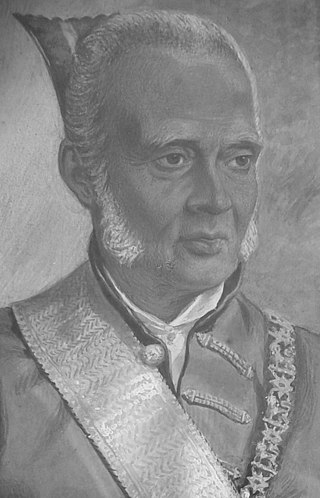
Gate Mudaliyar Jeronis de Soysa was a pioneering Ceylonese entrepreneur and philanthropist. He was a pioneer coffee planter and an industrialist who became the wealthiest Ceylonese of the 19th century by establishing the largest native commercial enterprise of the era. He was instrumental in the establishment of the first Ceylonese bank and is often referred to as a father of private enterprise in British Ceylon. He was the first Mudaliyar to be elevated in recognition of his philanthropy.
Walapane is a town located in Nuwara Eliya District of Sri Lanka. It is a high country area with many green mountains. It was called Wathtumulla in the past. The name Watumulla derived from the former tea factory which was located in the heart of the Walapane town and now demolished since the production of Wattumulla Plantation declined. Walapane is administrated by the government of *Sri Lanka through *Walapane Divisional Secretariat.
Deniyaya is a small town located towards the south of Sri Lanka. It is located in Matara District of the Southern Province. It is surrounded by the Sinharaja rainforest, and the climate is relatively cool. The main source of income is tea cultivation, however people also engage in vegetable cultivation. The village also has many historic temples such as the Gatabaruwa Devalaya.
Coffee production in Sri Lanka peaked in 1870, with over 111,400 hectares being cultivated. The Dutch had experimented with coffee cultivation in the 18th century, but it was not successful until the British began large scale commercial production following the Colebrooke–Cameron Commission reforms of 1833. By 1860, the country was amongst the major coffee-producing nations in the world. Although coffee production remains a source of revenue, it is no longer a main economic sector. In 2014, the country ranked 43rd of largest coffee producers in the world.
Cocoa production contributes to the national economy of Sri Lanka. It is grown in fairly dense shade and generally cultivated under coconut and rubber. Although cocoa production remains a source of revenue, it is no longer a main economic sector. The great part of cocoa cultivation occurs in the Matale, Kandy, Badulla, Kurunegala, Kegalle and Monaragala districts. The first cocoa plants were introduced to the country in 1819. Recent years cocoa production has increased by nearly $22.6 million (2015).
This page is based on this Wikipedia article Text is available under the CC BY-SA 4.0 license; additional terms may apply. Images, videos and audio are available under their respective licenses.