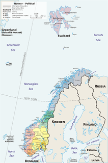
Spangereid is a former municipality in Vest-Agder county, Norway. The municipality existed from 1889 until its dissolution in 1964. The municipality was located in the southwestern part of the present-day municipality of Lindesnes. The municipality included the whole Lindesnes peninsula, plus part of the mainland adjacent to the narrow isthmus which connects the peninsula to the mainland. The administrative centre was the village of Høllen where the Spangereid Church is located.
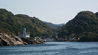
Hidra is a former municipality in Vest-Agder county, Norway. It is located in the present-day municipality of Flekkefjord. The 20.8-square-kilometre (8.0 sq mi) municipality existed from 1893 until its dissolution in 1965. It encompassed the islands and southern coastal part of the present-day municipality of Flekkefjord. The municipality included the islands of Hidra and Andabeløya as well as 56 other islands, plus the mainland coast from Abelsnes to the river Sira. The administrative centre was the village of Kirkehavn where Hidra Church is located.
Finsland or Finnsland is a village in Songdalen municipality in Vest-Agder county, Norway. The village is located about 25 kilometres (16 mi) northwest of Nodeland and about 8 kilometres (5.0 mi) southeast of the village of Bjelland. The village is very small and it is located in a very rural area, but it is the site of Finsland Church, the main church for the northern half of Songdalen municipality. The village was the administrative centre of the old municipality of Finsland which existed from 1838 until its dissolution in 1964.

Vigmostad is a village in Lindesnes municipality in Vest-Agder county, Norway. The village is located along the Audna river in the Audnedalen valley. The village of Konsmo lies about 10 kilometres (6.2 mi) to the north and about 15 kilometres (9.3 mi) north of the village of Vigeland. Vigmostad Church is located in the village.

Laudal is a village in Marnardal municipality in Vest-Agder county, Norway. The village is located on the western shore of the Mandalselva river, about 15 kilometres (9.3 mi) south of the village of Bjelland and about 9 kilometres (5.6 mi) north of the village of Øyslebø. The village of Laudal has 191 residents (2001). Laudal was the administrative centre of the old municipality of Laudal which existed from 1899 until its dissolution in 1964. Laudal Church is located in the small village.
Kumlevollvatnet or Kongevollvatnet is a lake in the municipality of Flekkefjord in Vest-Agder county, Norway. The 3.12-square-kilometre (1.20 sq mi) lake lies along the river Fedaelva, just south of Gyland and about 12 kilometres (7.5 mi) northeast of the town of Flekkefjord.

Austad is a village in Lyngdal municipality in Vest-Agder county, Norway. The village is located in the southern part of Lyngdal, about 6 kilometres (3.7 mi) south of the town of Lyngdal and the village of Korshamn. The village is on the eastern shore of the Rosfjorden. Austad Church is located in the center of the village. The village was the administrative centre of the old municipality of Austad which existed from 1909 until 1963.

Fjotland is a village in Kvinesdal municipality in Vest-Agder county, Norway. The village is located in the northern part of the Kvinesdalen valley on the northeast side of the lake Fjotlandsvatnet. Fjotland is about 17 kilometres (11 mi) southeast of the village of Haughom in Sirdal and about 25 kilometres (16 mi) north of Liknes. Fjotland was the administrative centre of the old municipality of Fjotland which existed prior to 1963. Fjotland Church is located in the village.

Vigeland is the administrative center of Lindesnes municipality in Vest-Agder county, Norway. The village is located along the river Audna, about 5 kilometres (3.1 mi) north of the river's mouth at the Snigsfjorden. The European route E39 highway runs east-west through Vigeland, connecting it to the town of Mandal, about 12 kilometres (7.5 mi) to the southeast. The 1.19-square-kilometre (290-acre) village has a population (2015) of 1,471 which gives the village a population density of 1,236 inhabitants per square kilometre (3,200/sq mi).
Nes is a former municipality in Vest-Agder county, Norway. The 150-square-kilometre (58 sq mi) municipality existed from 1893 until its dissolution in 1965. The municipality is located in the southwestern part of the present-day municipality of Flekkefjord. Its administrative centre was the village of Nes, located just outside the town of Flekkefjord.
Øyslebø og Laudal is a former municipality in Vest-Agder county, Norway. The 250-square-kilometre (97 sq mi) municipality existed from 1838 until 1899. The administrative centre was the village of Øyslebø. The municipality was located in the southern part of the present-day municipality of Marnardal.
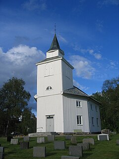
Øvrebø og Hægeland is a former municipality in Vest-Agder county, Norway. The 303-square-kilometre (117 sq mi) municipality existed from 1865 until its dissolution in 1896. It is located in the northern part of the present-day municipality of Vennesla, to the west of the Otra river. The administrative centre of the municipality was the village of Øvrebø, where Øvrebø Church is located.

Nes og Hitterø or Hitterø og Nes is a former municipality in Vest-Agder county, Norway. It is located in the southwestern part of the present-day municipality of Flekkefjord encompassing the Nes peninsula and the island of Hidra. The municipality existed from 1838 until its dissolution in 1893. The administrative centre of the municipality was the small village of Sunde in Nes parish, located just outside the town of Flekkefjord.

Hægeland or Hægelandskrossen is a village in Vennesla municipality in Vest-Agder county, Norway. The village is located along the northeastern shore of the lake Hægelandsvatnet, a short distance south of the Kilefjorden. The Norwegian National Road 9 runs north-south through the village, just past Hægeland Church. The village of Bjelland lies about 15 kilometres (9.3 mi) to the east and the villages of Skarpengland and Øvrebø both lie about 15 kilometres (9.3 mi) to the south. The village of Øvre Eikeland lies about 2 kilometres (1.2 mi) southeast of Hægeland, along the Rv9 highway.

Bakke is a former municipality in Vest-Agder county, Norway. The municipality existed from 1838 until its dissolution in 1965. It was located in the present-day municipalities of Sirdal and Flekkefjord. It included the whole Sirdalen valley along the Rogaland county border, stretching from the Aust-Agder county border in the north to Sirnes and the lake Lundevatnet in the south. The administrative center was the village of Sira where Bakke Church is located.

Gyland is a former municipality in Vest-Agder county, Norway. The 182-square-kilometre (70 sq mi) municipality is located in the northeastern part of the present-day municipality of Flekkefjord. The municipality existed very briefly from 1838 until 1839 and then it was re-created in 1893 and it existed until 1965. The administrative centre was the village of Gyland where Gyland Church is located.

Mandal is the administrative centre of Mandal municipality in Vest-Agder county, Norway. It is the second largest town by population in Vest-Agder county after Kristiansand and the fourth largest town in the Sørlandet/Agder region. The town is located at the mouth of the river Mandalselva at the southern end of the Mandalen valley. The 6.32-square-kilometre (1,560-acre) town has a population (2015) of 10,725 which gives the town a population density of 1,697 inhabitants per square kilometre (4,400/sq mi).
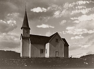
Laudal is a former municipality in Vest-Agder county, Norway. The 93-square-kilometre (36 sq mi) municipality existed from 1899 until 1964. The administrative centre of the municipality was the village of Laudal where Laudal Church is located. The municipality encompassed the central part of what is now the municipality of Marnardal.