
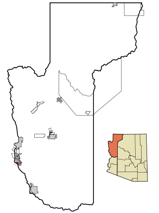
Mohave County occupies the northwestern corner of the U.S. state of Arizona. As of the 2020 census, its population was 213,267. The county seat is Kingman, and the largest city is Lake Havasu City. It is the fifth largest county in the United States.
Arizona Village is a census-designated place (CDP) on the Fort Mojave Indian Reservation in Mohave County, Arizona, United States. The population was 1,057 at the 2020 census, up from 946 in 2010 and 351 in 2000.

Bullhead City is a city located on the Colorado River in Mohave County, Arizona, United States, 97 miles (156 km) south of Las Vegas, Nevada, and directly across the Colorado River from Laughlin, Nevada, whose casinos and ancillary services supply much of the employment for Bullhead City. Bullhead City is located at the southern end of Lake Mohave.

Mohave Valley is an unincorporated community and census-designated place (CDP) in Mohave County, Arizona, United States. The population was 2,693 at the 2020 census. It is geographically connected to Needles, California, Fort Mohave and Bullhead City.

Peach Springs is a census-designated place (CDP) in Mohave County, Arizona, United States. The population was 1,098 at the 2020 census. Peach Springs serves as the administrative headquarters of the Hualapai people and is located on the Hualapai Reservation.

Willow Valley is an unincorporated community and census-designated place (CDP) in Mohave County, Arizona, United States. The population was 1,059 as of the 2020 census.

The Hualapai is a federally recognized Native American tribe in Arizona with about 2300 enrolled members. Approximately 1353 enrolled members reside on the Hualapai Reservation, which spans over three counties in Northern Arizona.

Littlefield is an unincorporated community and census-designated place in Mohave County, Arizona, United States, that is located in the Arizona Strip region. As of the 2020 census, its population was 256, a decline from the figure of 308 tabulated in 2010. It lies just south of Interstate 15, next to the Virgin River, approximately 10 miles (16 km) northeast of Mesquite, Nevada. Littlefield is located in the 86432 ZIP Code.

Wikieup is an unincorporated community and census-designated place (CDP) located on U.S. Route 93 in Mohave County, Arizona, United States. It is located approximately 139 miles (224 km) northwest of Phoenix and 162 miles (261 km) southeast of Las Vegas. As of the 2020 census, the population of Wikieup was 135.

Grand Canyon West is a census-designated place (CDP) in Mohave County, Arizona, United States, located on the Hualapai Reservation. The population was reported as 0 at the 2020 census. Grand Canyon West is home to the tribe's Grand Canyon business operations, including the Grand Canyon West Airport and the Grand Canyon Skywalk. Typically, they are open from 8:00 a.m. – 6:00 p.m., including all holidays.

Fort Mohave is an unincorporated community and census-designated place in Mohave County, Arizona, United States. It is named for a nearby fort that was used during the Mohave War. As of the 2020 census, the population of Fort Mohave was 16,190, up from 14,364 in 2010 and 8,919 in 2000. It is a suburb of Bullhead City. Its recent growth has made it the most populous unincorporated community in Mohave County.

Hackberry is an unincorporated community and census-designated place (CDP) in Mohave County, Arizona, United States. It is located on Arizona State Route 66 28 miles (45 km) northeast of Kingman. Hackberry has a post office which as of 2015 served 68 residential mailboxes with ZIP code 86411. As of the 2020 census, Hackberry had a population of 103.

Valentine is an unincorporated community and census-designated place (CDP) in Mohave County, Arizona, United States. As of the 2020 census it had a population of 39. Valentine is located on Arizona State Route 66 32 miles (51 km) northeast of Kingman. The majority of Valentine is located in a geographically isolated exclave of the Hualapai Reservation and the rest of the community is located in unincorporated Mohave County.
Valentine Elementary School District 22 is a public school district based in Mohave County, Arizona.

Antares is an unincorporated community and census designated place (CDP) in Mohave County, Arizona, United States. As of the 2020 census, it had a population of 132. It exists along part of historic U.S. Route 66.
Crozier is an unincorporated community and census-designated place (CDP) in Mohave County, Arizona, United States. The population was 21 at the 2020 census.
So-Hi is an unincorporated community and census-designated place in Mohave County, in the U.S. state of Arizona. The population was 428 at the 2020 census, down from 477 in 2010.

Truxton is an unincorporated community and census-designated place (CDP) in Mohave County, in the U.S. state of Arizona. The population was 104 at the 2020 census, down from 134 in 2010.

Valle Vista is an unincorporated community and census-designated place (CDP) in Mohave County, in the U.S. state of Arizona. The population was 1,802 at the 2020 census.

Walnut Creek is an unincorporated community and census-designated place (CDP) in Mohave County, in the U.S. state of Arizona. The population was 571 at the 2020 census.