Pitmatic, also colloquially known as "yakka", is a dialect of English used in the counties of Northumberland and Durham in England. It developed as a separate dialect from other Northumbrian dialects such as Geordie partly due to the specialised terms used by mineworkers in the local coal pits. For example, in Northumberland and Tyne and Wear the word Cuddy is an abbreviation of the name Cuthbert but in Durham Pitmatic cuddy denotes a horse, specifically a pit pony. In Lowland Scots, cuddie usually refers to a donkey or ass but may also denote a short, thick, strong horse.

The Arctic Archipelago, also known as the Canadian Arctic Archipelago, is a group of islands north of the Canadian mainland.

Tidewater is a reference to the Atlantic coastal plain region of the United States of America. It includes the low-lying plains of southeast Virginia, northeastern North Carolina, southern Maryland and the Chesapeake Bay. The area got its name from the effects of the changing tides on local rivers, sounds, and the ocean; there is also a cultural heritage that sets the Tidewater regions apart from other parts of the United States. Tidewater region was founded on principles of English gentry in a developing nation where patriotism, freedom and waterborne livelihoods existed. Dialects are distinctive and eroding along with islands and shoreline.
Mackem, Makem or Mak'em is the informal nickname for residents of and people from Sunderland, a city in North East England. It is also a name for the local accent ; and for a fan, whatever their origin, of Sunderland A.F.C. It has been used by the people of Sunderland to describe themselves since the 1980s, prior to which it was mainly used in Tyneside as a disparaging exonym. An alternative name for a Mackem is a Wearsider.

St Brides Bay is a bay in western Pembrokeshire, West Wales.
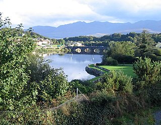
The River Laune is a river in County Kerry, Ireland, which flows from Lough Leane, one of the Lakes of Killarney, through Beaufort, past Ballymalis Castle, through the town of Killorglin, and empties into the sea, first at Castlemaine harbour beside the river Maine and then out through Dingle Bay. The Laune is well known for salmon and trout fishing.
The Vale of Clwyd(Welsh: Dyffryn Clwyd) is a tract of low-lying ground in the county of Denbighshire in northeast Wales. The Vale extends south-southwestwards from the coast of the Irish Sea for some 20 miles forming a triangle of low ground bounded on its eastern side by the well-defined scarp of the Clwydian Range and to the west by numerous low hills. The River Clwyd (Welsh: Afon Clwyd) which rises within Clocaenog Forest, southwest of Denbigh, runs the full length of the vale. It is joined by the two major left bank tributaries of the River Clywedog (Welsh: Afon Clywedog) and River Elwy (Welsh: Afon Elwy) and the smaller right bank tributary of the River Wheeler (Welsh: Afon Chwiler).
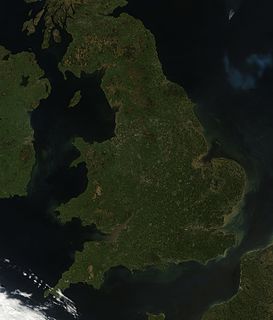
England comprises most of the central and southern two-thirds of the island of Great Britain, in addition to a number of small islands of which the largest is the Isle of Wight. England is bordered to the north by Scotland and to the west by Wales. It is closer to continental Europe than any other part of mainland Britain, divided from France only by a 33 km (21 mi) sea gap, the English Channel. The 50 km (31 mi) Channel Tunnel, near Folkestone, directly links England to mainland Europe. The English/French border is halfway along the tunnel.

Seal Rock is a group of small rock formation islands in the Lands End area of the Outer Richmond District in western San Francisco, California. They are located just offshore in the Pacific Ocean, at the north end of the Ocean Beach, near the Cliff House and Sutro Baths ruins.

The Manacles are a set of treacherous rocks off The Lizard peninsula in Cornwall. The rocks are rich in marine wildlife and they are a popular spot for diving due to the many shipwrecks. Traditionally pronounced mean-a'klz (1808), the name derives from the Cornish meyn eglos, the top of St Keverne church spire being visible from the area.
Dulong or Drung, Derung, Rawang, or Trung, is a Tibeto-Burman language in China. Dulong is closely related to the Rawang language of Myanmar (Burma). Although almost all ethnic Derung people speak the language to some degree, most are multilingual, also speaking Burmese, Lisu, and Mandarin Chinese except for a few very elderly people

The English language spoken and written in England encompasses a diverse range of accents and dialects. The dialect forms part of the broader British English, along with other varieties in the United Kingdom. Terms used to refer to the English language spoken and written in England include: English English, Anglo-English and British English in England.

Northumbria English is a dialect of Northern English linguistically closest to Lowland Scots. Northumbrian is made up of several dialects, with the Geordie dialect (Tyneside) being perhaps the most famous dialect spoken in Northumbria. The other dialects are Northern, Southern or Pitmatic, Mackem and arguably Smoggie (Teesside). It is spoken mainly if not exclusively in the modern day counties of Durham, Northumberland and Tyne and Wear. The Anglo-Saxon kingdom of Northumbria was much more extensive than this, covering Yorkshire and some parts of Lancashire and Scotland.
The Eden Rocks are two rocks lying 1.5 km off the east coast of Dundee Island, at the northern end of the Antarctic Peninsula. A small island was reported there on 30 December 1842 by Captain James Clark Ross of the Royal Navy, who named it "Eden Island" for Captain Charles Eden. Following a survey by the Falkland Islands Dependencies Survey in 1953, it was reported that the feature consists of two rocky islets rising to about 90 m in height and lying close together.
Sharpness Point is a small headland projecting into the North Sea at Tynemouth, Tyne and Wear. The O.S. grid reference is NZ371699.

Loch Sween is a sea loch located near Lochgilphead, Argyll and Bute, Scotland. Castle Sween is located on the southern shore towards the seaward end of the loch. The village of Tayvallich, a favoured haven for water craft as it sits at the head of sheltered Loch a' Bhealaich, lies on the northern shore.
The Tyne Songster is a chapbook style songbook, giving the lyrics of local, now historical songs, with a few bits of other information. It was published by W. & T. Fordyce of Newcastle upon Tyne in 1840.
Frenchman’s Bay is a small bay between South Shields and Marsden Grotto, Tyne and Wear. The O.S. grid reference is NZ392660.

Waterloo Bay is an area of foreshore in Larne, Northern Ireland.


