
Kvam is a municipality in Hordaland county, Norway. The municipality is located along the Hardangerfjorden in the traditional district of Hardanger. The administrative centre of the municipality is the village of Norheimsund. Other larger settlements in the municipality include Øystese, Bru, Ålvik, Tørvikbygd, Omastranda, and Mundheim. Historically, the municipality was named Vikør.
Haga is a surname and place name common to Norway, Sweden and Japan. Haga may refer to:
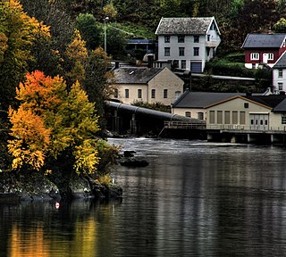
Norheimsund is the administrative centre of the municipality of Kvam in Hordaland county, Norway. The village is located on the northern side of the Hardangerfjord, about 80 kilometres (50 mi) from the city of Bergen. The village of Øystese lies about 4 kilometres (2.5 mi) to the northeast and the village of Vikøy lies about 3 kilometres (1.9 mi) southeast of Norheimsund. The village of Steine is a suburb, immediately to the west of Norheimsund. The 2.5-square-kilometre (620-acre) village has a population (2012) of 2,224; giving the village a population density of 890 inhabitants per square kilometre (2,300/sq mi), the largest settlement in the whole municipality.

Øystese is a village in the municipality of Kvam in Hordaland county, Norway. It is located along the Hardangerfjord about 7 kilometres (4.3 mi) east of the municipal centre of Norheimsund. Norwegian County Road 7 passes through the village. The 1.89-square-kilometre (470-acre) village has a population (2012) of 1,881; giving the village a population density of 995 inhabitants per square kilometre (2,580/sq mi).

Dale or Dalekvam is the administrative centre of Vaksdal municipality, in Hordaland county, Norway. The village lies at the western end of the Bergsdalen valley, about 5 kilometres (3.1 mi) northeast of the village of Stanghelle on the shore of the Veafjorden. The village lies along the European route E16, the Bergen Line, and the river Daleelva. The 0.72-square-kilometre (180-acre) urban area of Dale has a population (2013) of 1,163; giving the village area a population density of 1,615 inhabitants per square kilometre (4,180/sq mi). The small village of Dalegarden at the southern end of Dale is included in the "urban area" of Dale.

Skare or Skarde is a village in Odda municipality in Hordaland county, Norway. The village is located about 15 kilometres (9.3 mi) straight south of the town of Odda and about 5 kilometres (3.1 mi) northwest of the village of Seljestad. The village sits at the junction of Norwegian National Road 13 and European route E134. Skare Church is located in the village. The 0.29-square-kilometre (72-acre) village has a population (2013) of 320, giving the village a population density of 1,103 inhabitants per square kilometre (2,860/sq mi). The Espelandsfossen waterfall lies about 1.5 kilometres (0.93 mi) north of the village, just off the side of the National Road 13.
Bru or Ploganes is a village in the municipality of Kvam in Hordaland county, Norway. It's located in the Strandebarm area, on the northern shore of the Hardangerfjorden. It is located about 6 kilometres (3.7 mi) north of the village of Omastranda and about 10 kilometres (6.2 mi) northwest from the village of Kysnesstranda in Jondal Municipality.

Osøyro is the administrative centre of Os municipality in Hordaland county, Norway. The village lies on the southwestern part of the Bergen Peninsula, along the western shore of the Fusafjorden, about 25 kilometres (16 mi) south of the city centre of Bergen. The European route E39 highway runs through the village on its way to Bergen. There is a car ferry from the east side of Osøyro to the village of Fusa, across the Fusafjorden. Os Church is located in the village.
Søfteland or Syfteland is a village in Os municipality in Hordaland county, Norway. It lies on the Bergen Peninsula, along the European route E39 highway, about 6 kilometres (3.7 mi) north of the municipal centre of Osøyro and about 20 kilometres (12 mi) south of the city of Bergen. The mountain Møsnuken lies about 3.5 kilometres (2.2 mi) east of the village and the mountain Lyshornet lies about 2.3 kilometres (1.4 mi) west of the village. The 0.94-square-kilometre (230-acre) village has a population (2013) of 1425, giving the village a population density of 1,516 inhabitants per square kilometre (3,930/sq mi).

Knarrevik or Knarrvika is a village in Fjell municipality in Hordaland county, Norway. It is located along the Byfjorden on the eastern coast of the island of Litlesotra, just north of the municipal centre of Straume. The western end of the Sotra Bridge lies at Knarrevik.
Straume is the administrative center of Fjell municipality in Hordaland county, Norway. The village is located on the western part of the island of Litlesotra, just south of the village of Foldnes and southwest of the village of Knarrvika. Straume is the centre of government for the municipality and it is also the centre of commerce for the municipality. The large Sartor Senter, a regional shopping center is located in Straume.
Eikelandsosen is the administrative center of the municipality of Fusa in Hordaland county, Norway. It is located at the end of the Eikelandsfjorden, a small arm off the main Fusafjorden. The village sits to the southeast of the village of Holmefjord, west of the village of Holdhus, and northeast of the village of Fusa. The 0.7-square-kilometre (170-acre) village has a population (2013) of 477, giving the village a population density of 681 inhabitants per square kilometre (1,760/sq mi).

Fedje is the administrative centre of Fedje municipality in Hordaland county, Norway. The village is located on the northern shores of the island of Fedje. The fishing village is an old trading center, which grew up around Kræmmerholmen, a small island in the Fedje harbor. The 0.68-square-kilometre (170-acre) village has a population (2013) of 429, giving the village a population density of 631 inhabitants per square kilometre (1,630/sq mi). Fedje Church is located in the village, serving the people of the whole municipality.

Lofthus is a village in the municipality of Ullensvang, which is located in the Hardanger region of Hordaland county, Norway. The village lies along the eastern shore of the Sørfjorden, along Norwegian National Road 13. Lofthus is located about 10 kilometres (6.2 mi) south of the village of Kinsarvik and about 30 kilometres (19 mi) north of the town of Odda. The 0.67-square-kilometre (170-acre) village of Lofthus has a population (2013) of 556, giving the village a population density of 830 inhabitants per square kilometre (2,100/sq mi).
Tysse is the administrative centre of Samnanger municipality in Hordaland county, Norway. The village is located near the end of the Samnangerfjorden. It is located immediately south of the village of Haga, and it is considered to be part of the "urban area" of Haga by Statistics Norway. The village lies at the mouth of the river Tysseelva which runs through the Tyssedalen valley.
Årland is a village in Samnanger municipality in Hordaland county, Norway. The village is located on the northeastern shore of the Samnangerfjorden, west of the village of Haga. It sits along Norwegian County Road 7, which runs from the city of Bergen to Samnanger. Samnanger Church is located in this village. The newspaper Samningen has been published in Årland since 1977.

Haga Church is a parish church in Samnanger municipality in Hordaland county, Norway. It is located in the village of Haga. The church is part of the Samnanger parish in the Hardanger og Voss deanery in the Diocese of Bjørgvin. The white, wooden church was built in 1995 by the architect Helge Hjertholm. The church was consecrated on 5 February 1995. The church has a fan-shaped sanctuary that seats about 230 people.
Hammarsland is a village in Sund municipality in Hordaland county, Norway. The village is located on the island of Sotra, just east of the municipal centre of Skogsvåg in the northern part of the municipality. The 0.56-square-kilometre (140-acre) village has a population (2013) of 875, giving the village a population density of 1,563 inhabitants per square kilometre (4,050/sq mi).
Sveio is the administrative centre of Sveio municipality in Hordaland county, Norway. The village is located on the northwestern shore of the lake Vigdarvatnet, about half-way between the villages of Våga and Førde. The 0.88-square-kilometre (220-acre) village has a population (2013) of 1336, giving the village a population density of 1,518 inhabitants per square kilometre (3,930/sq mi). The village lies along Norwegian County Road 47. Sveio Church is located here. The newspaper Vestavind has been published in Sveio since 1986.


