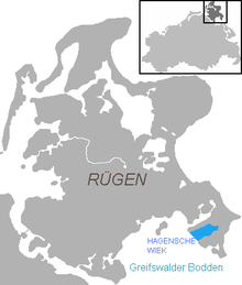
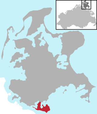
Hagensche Wiek is a cove in the east of the Rügischer Bodden that cuts deeply into the Mönchgut peninsula, the southeast tip of the German island of Rügen.
It is about 5kilometres long, 2.5kilometres wide and opens towards the southwest onto the Rügischer Bodden, the northern half of the Bay of Greifswald. In the north, the Hagensche Wiek is bounded by the narrow, elongated peninsula of Reddevitzer Höft, in the south by the actual Mönchgut with the Zicker Hills (Zickersche Berge), up to 66 metres high. In the east the cove approaches within 1,000 metres of the Baltic Sea coast not far from the village of Lobbe in the municipality of Middelhagen.
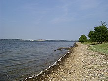
View over the Hagensche Wiek towards the peninsula of Reddevitzer Höft
Gager harbour on the Hagensche Wiek
The municipalities of Gager and Middelhagen with their hamlets of Alt Reddevitz and Mariendorf lie on the Hagensche Wiek. In Gager is the only harbour on the bay, used by fishing and sports boats and protected by a mole.
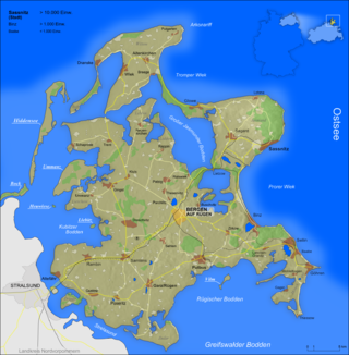
Rügen is Germany's largest island. It is located off the Pomeranian coast in the Baltic Sea and belongs to the state of Mecklenburg-Western Pomerania.
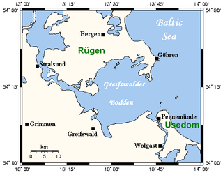
The Bay of Greifswald or Greifswald Bodden is a basin in the southwestern Baltic Sea, off the shores of Germany in the state of Mecklenburg-Vorpommern. With an area of 514 km², it is the largest Bodden of the German Baltic coast.
Mönchgut is a peninsula of 29.44 square kilometers with 6600 inhabitants in the southeast of Rügen island in Mecklenburg-Western Pomerania, Germany. It lies just between the Greifswalder Bodden and the rest of the Baltic Sea. Mönchgut contains the districts of Göhren and Thiessow; the peninsula is part of the Mönchgut-Granitz administration area. It is also a part of the Biosphere Reserve of Südost-Rügen.
The island of Ummanz lies in the Baltic Sea, off the west coast of the island of Rügen, and belongs, like the latter, to the county of Vorpommern-Rügen in the German state of Mecklenburg-Western Pomerania.
Bodden are briny bodies of water often forming lagoons, along the southwestern shores of the Baltic Sea, primarily in Germany's state of Mecklenburg-Vorpommern. These lagoons can be found especially around the island of Rügen, Usedom and the Fischland-Darss-Zingst peninsula. Some of them are protected reserves, forming the Western Pomerania Lagoon Area National Park.
Trent is a municipality in the Vorpommern-Rügen district, in Mecklenburg-Vorpommern, Germany.
The Großer Jasmunder Bodden belongs to the Northern Rügener Boddens and is a water body on the southern edge of the Baltic Sea in the German state of Mecklenburg-Vorpommern. It is a bodden, a type of lagoon that occurs in northern Europe especially on the coast of Pomerania. It lies within the island of Rügen, is around 14 kilometres long, an average of six kilometres wide and is up to nine metres deep with an average depth of 5.3m. The Großer Jasmunder Bodden has an area of 58.6 square kilometres; if the Breetzer Bodden, Breeger Bodden, Lebbiner Bodden, Neuendorfer Wiek and Tetzitzer See are included the total area of water comes to over 94 square kilometres.
The Udarser Wiek is a bay on Germany's Baltic Sea coast, covering an area of about 8 km², between the islands of Rügen in the north and Ummanz in the south. In the west, the bodden transitions into the Schaproder Bodden and in the southeast to the Gahlitz in the lake of Koselower See. At the northeast end of the bay lies the island of Öhe.
The Schmale Heide is a 9.5-kilometre-long and roughly 2-kilometre-wide bar between the Baltic seaside resort of Binz and the village of Neu Mukran near Sassnitz on the German island of Rügen. It lies in the municipality of Binz and is bounded to the northwest by the lagoon of the Kleiner Jasmunder Bodden and to the east by the bay of Prorer Wiek.
The Wieker Bodden is a lagoon or bodden, that is largely surrounded by the German Baltic Sea island of Rügen. It is part of the North Rügen Bodden Chain.
The Zudar is a peninsula on the German Baltic Sea island of Rügen. It is about 18 square kilometres in area and sharply divided.
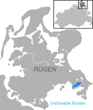
The Rügische Bodden is a bay which is part of a larger stretch of water, the Greifswalder Bodden, bounded on two sides by the German mainland and on a third by the Baltic Sea island of Rügen. It is located southeast of Rügen island between Mönchgut and the Zudar peninsula. At Mönchgut, several headlands project into the bodden: the Reddevitz Höft, the Klein Zicker and the Großer Zicker. The inlet between Rügen and the Reddevitzer Höft is known as Having; between the Reddevitzer Höft and the Großer Zicker lies the inlet of Hagensche Wiek. Other bays are the Schoritzer Wiek, the Selliner See and the Neuensiener See. Its southern boundary would be the line between the headlands of the Zudar and Mönchgut peninsulas. There are harbours in Lauterbach, Baabe and Seedorf.
The Schaabe is a bar, almost twelve kilometres long, on the German Baltic Sea island of Rügen. It joins the peninsulas of Jasmund and Wittow.
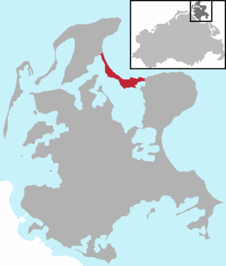
The Having is an inlet in the northeast of the Rügischer Bodden, the northern half of the Bay of Greifswald, which cuts deeply into the peninsula of Mönchgut, the southeastern tip of the German island of Rügen.
The Reddevitz Höft or Reddevitzer Höft is a peninsular forming part of the German Baltic Sea island of Rügen. It is part of the Mönchgut peninsula, with which it is linked in the southeast by a good 130 metre wide isthmus. The Reddevitzer Höft is over four kilometres long and up to 500 metres wide. In its western part, which end in a cliffed coast, the land climbs to a height of over 33 metres. At the eastern end is the village of Alt Reddevitz, part of the municipality of Middelhagen. The namen is derived from the Low German word höft for "head".
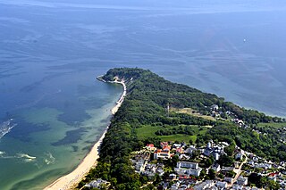
The Nordperd(Perd = Slavic for protrusion or prominence) is a cape on the German Baltic Sea island of Rügen. It is part of the Southeast Rügen Biosphere Reserve and the Mönchgut Nature Reserve.
The Southeast Rügen Biosphere Reserve is a biosphere reserve in the German state of Mecklenburg-Vorpommern, which covers the southeastern part of the island of Rügen, the lagoon of Rügischer Bodden between Putbus and Thiessow, the outer coast between Thiessow and Binz and the island of Vilm.
The Wreecher See is a cove, southwest of the town of Putbus on the German Baltic Sea island of Rügen.
The All Saints Day flood of 1304 was a storm surge that hit the southwestern Baltic Sea coast on 1 November that year. The region of Western Pomerania was particularly badly affected by the flooding. 271 people died as a result of the flood. The dating of the disaster to All Saints' Day in 1304, which gave the flood its name, goes back to the Stralsundische Chronik by Johann Berckmann. This date is, however, not confirmed, although it is probable that the year was 1304.
Mönchgut is a municipality in the district of Vorpommern-Rügen, in Mecklenburg-Vorpommern, Germany. It was created with effect from 1 January 2018 by the merger of the former municipalities of Gager, Middelhagen and Thiessow. Its name derives from the Mönchgut peninsula.
This page is based on this Wikipedia article Text is available under the CC BY-SA 4.0 license; additional terms may apply. Images, videos and audio are available under their respective licenses.