Related Research Articles

The Wetʼsuwetʼen are a First Nation who live on the Bulkley River and around Burns Lake, Broman Lake, and François Lake in the northwestern Central Interior of British Columbia.
Bulkley Junction Provincial Park is a provincial park in British Columbia, Canada, located on the west side of the Skeena River opposite Hazelton. It was established in 1997 and expanded in 2004 from 133 ha. to its current size of 169 ha.
Boulder Creek Provincial Park is a provincial park in British Columbia, Canada, located to the west of BC Highway 16 near Smithers, in the Bulkley Valley.
Driftwood Canyon Provincial Park is a provincial park in British Columbia, Canada. Driftwood Canyon Provincial Park covers 23 hectares of the Bulkley River Valley, on the east side of Driftwood Creek, a tributary of the Bulkley River, 10 km northeast of the town of Smithers. The park is accessible from Driftwood Road from Provincial Highway 16. It was created in 1967 by the donation of the land by the late Gordon Harvey (1913–1976) to protect fossil beds on the east side of Driftwood Creek. The beds were discovered around the beginning of the 20th century. The park lands are part of the asserted traditional territory of the Wet'suwet'en First Nation.

The Bulkley Valley is in the northwest Central Interior of British Columbia, Canada.

Witset is a Wet'suwet'en village in Central British Columbia, Canada on the west side of the Bulkley River on Coryatsaqua (Moricetown) Indian Reserve No. 2, and on Moricetown Indian Reserve No.1. The current village was built during the early 1900s. Evidence of inhabitants date back to around 5,500 years ago.

The Hazelton Mountains are a grouping of mountain ranges on the inland lee of the Kitimat Ranges of the Coast Mountains in northwestern British Columbia, Canada, spanning the area of Hazelton south to the Nechako Reservoir. Defined by the British Columbia geographic names office, they span from the Nass River to the Nechako Plateau, and between the Coast Mountains and the Bulkley River, they are considered by geographers to be part of the Interior Mountains complex, though in local perspective they are considered to be part of the Coast Mountains. They are neighboured on the west by the Kitimat Ranges and on the east by the southernmost section of the Skeena Mountains; beyond the Nass River, which is their northern boundary, are the Boundary Ranges of the Coast Mountains. To their southeast is the Nechako Plateau, including the Quanchus Range on the near-island between Ootsa and Eutsuk Lakes of the Nechako Reservoir.

The Stswecem'c Xgat'tem First Nation, formerly known as Canoe Creek Band/Dog Creek Indian Band, created as a result of merger of the Canoe Creek Band and Dog Creek Band is a First Nations government of the Secwepemc (Shuswap) Nation, located in the Fraser Canyon-Cariboo region of the Central Interior of the Canadian province of British Columbia. It was created when the government of the then-Colony of British Columbia established an Indian reserve system in the 1860s. It is a member government of the Northern Shuswap Tribal Council.
The Lytton First Nation, a First Nations band government, has its headquarters at Lytton in the Fraser Canyon region of the Canadian province of British Columbia. While it is the largest of all Nlaka'pamux bands, unlike all other governments of the Nlaka'pamux (Thompson) people, it is not a member of any of the three Nlaka'pamux tribal councils, which are the Nicola Tribal Association, the Fraser Canyon Indian Administration and the Nlaka'pamux Nation Tribal Council.
New Hazelton is a district municipality on the south side of the Bulkley River in the Skeena region of west central British Columbia, Canada. On BC Highway 16, the locality is by road about 68 kilometres (42 mi) northwest of Smithers and 137 kilometres (85 mi) northeast of Terrace. New Hazelton is one of the "Three Hazeltons", the other two being the original "Old" Hazelton to the northwest and South Hazelton to the west.
The Bulkley Ranges are a mountain range in northern British Columbia, Canada, located between the Skeena and Bulkley Rivers south of Hazelton, north of the Morice River and Zymoetz River. It has an area of 7851 km2 and is a subrange of the Hazelton Mountains which in turn form part of the Interior Mountains.
Hagwilget Canyon is a canyon on the Bulkley River of northwestern British Columbia, Canada, located several kilometres upstream from that river's confluence with the Skeena River at Hazelton, at the Wet'suwet'en village of Hagwilget.

ʼKsan is a historical village and living museum of the Gitxsan Indigenous people in the Skeena Country of Northwestern British Columbia, Canada. ʼKsan is located near Hazelton at the confluence of the Skeena and Bulkley Rivers on Gitxsan territory.
The Skeena Country is a historic geographic region comprising areas of both the British Columbia Coast and the British Columbia Interior in northwestern British Columbia, Canada.
The Rocher Déboulé Range, formerly known as the Roche Déboulé Mountains, is a subrange of the Bulkley Ranges, located south of Hazelton in northern British Columbia, Canada.
The Telkwa Range is a subrange of the Bulkley Ranges, located south of the junction of the Telkwa River and Bulkley River in northern British Columbia, Canada.
Horneline Creek Provincial Park is a provincial park in far northern British Columbia, Canada. It is located west of the Kechika River about 130 km south of Lower Post and 30 km north of Denetiah Provincial Park and southwest of the community of Liard River.
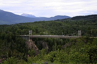
Hagwilget Canyon Bridge is a suspension bridge over the Hagwilget Canyon on the Bulkley River, at the Wet'suwet'en village of Hagwilget, British Columbia. The current bridge was constructed in 1931, and later reinforced in 1990.
Kelly Lake is a community in the Peace River Country of northeastern British Columbia, Canada. It is west of the border with the province of Alberta.

Hagwilget Peak is the northernmost mountain in the Rocher Déboulé Range in northern British Columbia, Canada. The 2,076-metre (6,811-foot) mountain summit is conspicuously situated immediately south of Hazelton, British Columbia. Overlooking New Hazelton, it rises 1,770 m (5,807 ft) above the surrounding valley. Precipitation runoff from the mountain drains into the Skeena River and Bulkley River. Based on the Köppen climate classification, Hagwilget Peak is located in a subarctic climate zone with cold, snowy winters, and mild summers. Temperatures can drop below −20 °C with wind chill factors below −30 °C. Originally labelled Nil-ke-auda on George Dawson's map for an 1879–80 report for the Geological Survey of Canada, it was later adopted as Awillgate Peak in 1917. The spelling changed to Hagwilget Peak on 1 February 1963, when officially adopted by the Geographical Names Board of Canada to conform with the modern spelling of the namesake village, Hagwilget.
References
| | This First Nations in Canada-related article is a stub. You can help Wikipedia by expanding it. |
| | This article about a location in the Cariboo Regional District, Canada is a stub. You can help Wikipedia by expanding it. |