
Wetʼsuwetʼen are a First Nations people who live on the Bulkley River and around Burns Lake, Broman Lake, and Francois Lake in the northwestern Central Interior of British Columbia. The name they call themselves, Wetʼsuwetʼen, means "People of the Wa Dzun Kwuh River or Bulkley River".
Bulkley Junction Provincial Park is a provincial park in British Columbia, Canada, located on the west side of the Skeena River opposite Hazelton.
Boulder Creek Provincial Park is a provincial park in British Columbia, Canada, located to the west of BC Highway 16 near Smithers, in the Bulkley Valley.

The Bulkley Valley is located in the northwest Central Interior of British Columbia, Canada.

Witset is a Wet'suwet'en village in Central British Columbia, Canada on the west side of the Bulkley River on Coryatsaqua (Moricetown) Indian Reserve No. 2, and on Moricetown Indian Reserve No.1. The current village was built during the early 1900s. Evidence of inhabitants date back to around 5,500 years ago.
Seeley Lake Provincial Park is a provincial park in British Columbia, Canada, located south of the confluence of the Skeena and Bulkley Rivers at Hazelton, and to the south of that settlement.
Stuart River Provincial Park is a provincial park in British Columbia, Canada. It is located in two sections north and northwest of Vanderhoofalong the Stuart River southeast of Stuart Lake and the city of Fort St. James. The upper section is located at 54°13′20″N124°00′00″W and comprises c.7391 ha. while the lower, eastern section is centred at 54°03′00″N123°37′00″W and comprises c.3390 ha. and is within the Greater Prince George area. The upper site, which is located around the confluence of the Stuart and Nechako Rivers, includes the site of Chinlac, a Dakelh village whose inhabitants were massacred and enslaved by the Tsilhqot'in of Anahim Lake c. 1745.

The Knik Glacier is located just 50 miles (80 km) east of Anchorage, Alaska on the northern end of the Chugach Mountains. The ice field averages over 25 miles (40 km) long and over 5 miles (8.0 km) across, making it one of the largest glaciers in southcentral Alaska. Knik Glacier feeds the 25-mile (40 km) long Knik River which empties into the Knik Arm section of Cook Inlet.

The Canoe Creek Band/Dog Creek Indian Band, also known as the Canoe Creek First Nation and/or Dog Creek First Nation is a First Nations government of the Secwepemc (Shuswap) Nation, located in the Fraser Canyon-Cariboo region of the Central Interior of the Canadian province of British Columbia. It was created when the government of the then-Colony of British Columbia established an Indian Reserve system in the 1860s. It is a member government of the Northern Shuswap Tribal Council.
The Lytton First Nation, a First Nations government, has its headquarters at Lytton in the Fraser Canyon region of the Canadian province of British Columbia. While it is the largest of all Nlaka'pamux bands, unlike all other governments of the Nlaka'pamux (Thompson) people, it is not a member of any of the three Nlaka'pamux tribal councils, which are the Nicola Tribal Association, the Fraser Canyon Indian Administration and the Nlaka'pamux Nation Tribal Council.
The Bulkley Ranges is mountain range in northern British Columbia, Canada, located between the Skeena and Bulkley Rivers south of Hazelton, north of the Morice River and Zymoetz River. It has an area of 7851 km2 and is a subrange of the Hazelton Mountains which in turn form part of the Interior Mountains.

'Ksan is a historical village and living museum of the Gitxsan Indigenous people in the Skeena Country of Northwestern British Columbia, Canada. 'Ksan is located near Hazelton at the confluence of the Skeena and Bulkley Rivers on Gitxsan territory.
Hagwilget or Hagwilgyet is a First Nations reserve community of the Wet'suwet'en people located on the lower Bulkley River just east of Hazelton in northwestern British Columbia, Canada. The community's name means "well-dressed" as in "ostentatious," though another meaning is "the quiet people". It has also been spelled Awillgate and Ackwilgate and it has also been named Rocher Déboulé - "falling rock" - a reference to a landslide in this area from Rocher Déboulé Mountain, which blocked salmon runs on the Bulkley River at this location.
The Telkwa Range is a subrange of the Bulkley Ranges, located south of the junction of the Telkwa River and Bulkley River in northern British Columbia, Canada.
Horneline Creek Provincial Park is a provincial park in far northern British Columbia, Canada. It is located west of the Kechika River about 130 km south of Lower Post and 30 km north of Denetiah Provincial Park and southwest of the community of Liard River.
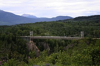
Hagwilget Canyon Bridge is a suspension bridge over the Hagwilget Canyon on the Bulkley River, at the Wet'suwet'en village of Hagwilget, British Columbia. The current bridge was constructed in 1931, and later reinforced in 1990.
Katit Indian Reserve No. 1 is the main Indian reserve of the Wuikinuxv people, and is one of the three reserves governed by the Wuikinuxv Nation band government. It is located in British Columbia, Canada, on the entrance to Owikeno Lake on the north side of the Wannock River near to, but separate from, the non-native community and sport fishing resort of Rivers Inlet. Similarly-named Katit Island is in the Wannock River at 51°40′41″N127°11′48″W, while Kahtit Creek is downstream, near the mouth of the Wannock River at 51°40′47″N127°15′00″W near the Wuikinuxv village known as Oweekeno.


