Hakahana

Last updated
Hakahana
Hakahana.JPG
Shacks in Hakahana (2011)
Karte Vorstadt Windhoek-Hakahana.png
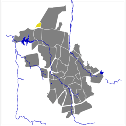
Suburb Hakahana (yellow) in the City of Windhoek
Namibia location map.svg
Red pog.svg
Hakahana
Hakahana in Namibia
Coordinates: 22°30′25″S17°6′12″E / 22.50694°S 17.10333°E / -22.50694; 17.10333
CountryFlag of Namibia.svg  Namibia
Time zone UTC+2 (South African Standard Time)

Hakahana is a suburb of Windhoek, the capital of Namibia. The township is situated in the north of the town between the suburbs of Katutura, Wanaheda, and Okuryangava.

Hakahana was also a former constituency in Khomas Region, Namibia. In 2003, the constituency was split into Eastern Hakahana and Western Hakahana, both soon renamed into Tobias Hainyeko constituency and Moses ǁGaroëb constituency, respectively. Hakahana means "Hurry up" in Otjiherero. [1]

Related Research Articles

<span class="mw-page-title-main">ǁKaras Region</span> Region in Namibia

The ǁKaras Region is the southernmost, largest, and least densely populated of the 14 regions of Namibia; its capital is Keetmanshoop. The name assigned to the region reflects the prominence of the Karas mountain range in its southern part. The ǁKaras region contains the municipality of Keetmanshoop, the towns Karasburg, Lüderitz and Oranjemund, and the self-governed villages Aroab, Berseba, Bethanie, Koës and Tses.

<span class="mw-page-title-main">Erongo Region</span> Region in Namibia

Erongo is one of the 14 regions of Namibia. The capital is Swakopmund. It is named after Mount Erongo, a well-known landmark in Namibia and in this area. Erongo contains the municipalities of Walvis Bay, Swakopmund, Henties Bay and Omaruru, as well as the towns Arandis, Karibib and Usakos. All the main centres within this region are connected by paved roads.

<span class="mw-page-title-main">Khomas Region</span> Region in Namibia

Khomas is one of the fourteen regions of Namibia. Its name refers to the Khomas Highland, a high plateau landscape that dominates this administrative subdivision. Khomas is centered on the capital city Windhoek and provides for this reason superior transportation infrastructure. It is located in the central highlands of the country and is bordered by the Erongo region to the west and the northwest and by the Otjozondjupa region to the north. To the east is the Omaheke region, while in the south is the Hardap region. The region is characterized by its hilly countrysize and many valleys. It has well-developed economical, financial, and trade sectors. Khomas Region occupies 4.5% of the land area of Namibia but has the highest population of any of its regions (16.2%). Khomas is one of only three Namibian regions to have neither shoreline nor a foreign border.

<span class="mw-page-title-main">Otjozondjupa Region</span> Region in Namibia

Otjozondjupa is one of the fourteen regions of Namibia. Its capital is Otjiwarongo. The region further contains the municipalities of Okahandja and Grootfontein and the towns Okakarara and Otavi. As of 2020, Otjozondjupa had 97,945 registered voters.

<span class="mw-page-title-main">Oshikoto Region</span> Region in Namibia

Oshikoto is one of the fourteen regions of Namibia, named after Lake Otjikoto. Its capital is Omuthiya. Further major settlements in the region are Tsumeb, Otjikoto's capital until 2008, and Oniipa. As of 2020, Oshikoto had 112,170 registered voters.

<span class="mw-page-title-main">Omusati Region</span> Region in Namibia

Omusati is one of the fourteen regions of Namibia, its capital is Outapi. The towns of Okahao, Oshikuku and Ruacana as well as the self-governed village Tsandi are situated in this region. As of 2020, Omusati had 148,834 registered voters.

<span class="mw-page-title-main">Omaheke Region</span> Region in Namibia

Omaheke is one of the fourteen regions of Namibia, the least populous region. Its capital is Gobabis. It lies in eastern Namibia on the border with Botswana and is the western extension of the Kalahari desert. The self-governed villages of Otjinene, Leonardville and Witvlei are situated in the region. As of 2020, Omaheke had 48,594 registered voters.

<span class="mw-page-title-main">Ohangwena Region</span> Region in Namibia

Ohangwena is one of the fourteen regions of Namibia, its capital is Eenhana. Major settlements in the region are the towns Eenhana and Helao Nafidi as well as the self-governed village of Okongo and the proclaimed settlements Ongenga and Omungwelume. As of 2020, Ohangwena had 150,724 registered voters.

<span class="mw-page-title-main">Kunene Region</span> Region in Namibia

Kunene is one of the fourteen regions of Namibia. Its capital is Opuwo, its governor is Marius Sheya. The region's name comes from the Kunene River which forms the northern border with Angola. Besides the capital Opuwo, the region contains the municipality of Outjo, the town Khorixas and the self-governed village Kamanjab. Kunene is home to the Himba people, a subtribe of the Herero, as well as to Damara people and Nama people. As of 2020, Kunene had 58,548 registered voters.

<span class="mw-page-title-main">Regions of Namibia</span>

Namibia uses regions as its first-level subnational administrative divisions. Since 2013, it has 14 regions which in turn are subdivided into 121 constituencies.

<span class="mw-page-title-main">Samora Machel Constituency</span> Electoral constituency in the Khomas region of central Namibia

Samora Machel Constituency is a constituency in Windhoek in the Khomas Region of central Namibia. The constituency is located across four northern suburbs of Windhoek: Wanaheda, Greenwell Matongo, Goreangab, and part of Havana. It had a population of 50,110 in 2011, up from 29,382 in 2001. As of 2020 it had 45,962 registered voters.

<span class="mw-page-title-main">John Pandeni Constituency</span> Electoral constituency in the Khomas region of central Namibia

John Pandeni constituency, formerly known as Soweto is a constituency in the Khomas Region of Namibia. In 2008, it was renamed after John Pandeni, a member of the South West Africa People's Organization (SWAPO) and its militant wing, the People's Liberation Army of Namibia (PLAN). Pandeni was the first regional councilor for the former Soweto constituency and the first governor of Khomas. This constituency is inside the city of Windhoek in the formerly all-Black suburb of Katutura. It had a population of 15,121 in 2011, up from 13,865 in 2001. As of 2020, it has 14,758 registered voters.

<span class="mw-page-title-main">Tobias Hainyeko constituency</span> Electoral constituency in the Khomas region of central Namibia

Tobias Hainyeko constituency is an electoral constituency in Windhoek, the capital of Namibia. It had a population of 45,912 in 2011, up from 34,348 in 2001. As of 2020 it had 36,530 registered voters.

<span class="mw-page-title-main">Administrative divisions of Namibia</span>

Namibia is divided into 14 regions subdivided, which are further subdivided into 121 constituencies. The administrative divisions of Namibia are tabled by Delimitation Commissions and accepted or declined by the National Assembly.

<span class="mw-page-title-main">2015 Namibian local and regional elections</span> Elections in Namibia

Namibia held elections for their local and regional councils on 27 November 2015. Ballots were cast using electronic voting.

<span class="mw-page-title-main">Ncuncuni Constituency</span> Electoral constituency in the Kavango West region of northern Namibia

Ncuncuni is a constituency in the Kavango West region of Namibia. It is located west of Rundu, one of Namibia's largest cities. It had a population of 38,281 in 2011, up from 26,623 in 2001. As of 2020 the constituency had 4,554 registered voters.

<span class="mw-page-title-main">2020 Namibian local and regional elections</span> Elections in Namibia

Local and regional elections were held in Namibia on 25 November 2020 to elect new local and regional councils. The previous round of elections was held in 2015 and won by the ruling SWAPO party.

References

  1. Maletsky, Christof (27 August 2008). "Constituency named after John Pandeni". The Namibian . Archived from the original on 4 December 2008.