Windhoek is the capital and largest city of the Republic of Namibia. It is located in central Namibia in the Khomas Highland plateau area, at around 1,700 metres (5,600 ft) above sea level, almost exactly at the country's geographical centre. The population of Windhoek in 2011 was 325,858, growing continually due to an influx from all over Namibia.
Namibia, officially the Republic of Namibia, is a country in southern Africa. Its western border is the Atlantic Ocean; it shares land borders with Zambia and Angola to the north, Botswana to the east and South Africa to the south and east. Although it does not border Zimbabwe, less than 200 metres of the Zambezi River separates the two countries. Namibia gained independence from South Africa on 21 March 1990, following the Namibian War of Independence. Its capital and largest city is Windhoek, and it is a member state of the United Nations (UN), the Southern African Development Community (SADC), the African Union (AU), and the Commonwealth of Nations.
A suburb is a mixed-use or residential area, existing either as part of a city or urban area or as a separate residential community within commuting distance of a city. In most English-speaking countries, suburban areas are defined in contrast to central or inner-city areas, but in Australian English and South African English, suburb has become largely synonymous with what is called a "neighborhood" in other countries and the term extends to inner-city areas. In some areas, such as Australia, India, China, New Zealand, the United Kingdom, and a few U.S. states, new suburbs are routinely annexed by adjacent cities. In others, such as Saudi Arabia, Canada, France, and much of the United States, many suburbs remain separate municipalities or are governed as part of a larger local government area such as a county.
Windhoek Central consists of residential and business properties as well as public spaces. Most of Windhoek's governmental and administrative buildings are situated here. The name addition Business District refers to the possibility to apply for business rights which is generally granted for erven in Windhoek that are situated in any proclaimed business district.
A cadastre is a comprehensive land recording of the real estate or real property's metes-and-bounds of a country.
In Windhoek, Namibia, Independence Avenue runs through the heart of downtown and is "easily explored by foot". Prior to independence, the street was known as Kaiserstrasse.
The Alte Feste is a fortress and museum in downtown Windhoek, the capital of Namibia.
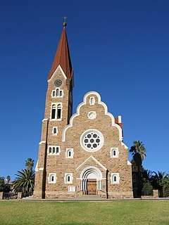
The Christ Church is a historic landmark and Lutheran church in Windhoek, Namibia, designed by architect Gottlieb Redecker.
A geographic coordinate system is a coordinate system that enables every location on Earth to be specified by a set of numbers, letters or symbols. The coordinates are often chosen such that one of the numbers represents a vertical position and two or three of the numbers represent a horizontal position; alternatively, a geographic position may be expressed in a combined three-dimensional Cartesian vector. A common choice of coordinates is latitude, longitude and elevation. To specify a location on a plane requires a map projection.
This page is based on this Wikipedia article Text is available under the CC BY-SA 4.0 license; additional terms may apply. Images, videos and audio are available under their respective licenses.
Related Research Articles
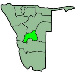
Khomas is one of the fourteen regions of Namibia. Its name refers to the Khomas Highland, a high plateau landscape that dominates this administrative unit. Khomas is centered on the capital city Windhoek and provides for this reason superior transportation infrastructure. It is located in the central highlands of the country and is bordered by the Erongo region to the west and the northwest and by the Otjozondjupa region to the north. To the east is the Omaheke region, while in the south is the Hardap region. The region is characterized by its hilly countrysize and many valleys. It has well-developed economical, financial, and trade sectors. Khomas Region occupies 4.5% of the land area of Namibia but has the highest population of any of its regions (15%). Khomas is one of only three Namibian regions to have neither shoreline nor a foreign border.
Omaheke is one of the fourteen regions of Namibia, its capital is Gobabis. It lies on the eastern border of Namibia and is the Western extension of the Kalahari desert. The name Omaheke is the Herero word for Sandveld.
Karibib is a town in the Erongo Region of western Namibia. It has 3,800 inhabitants and owns 97 square kilometres (37 sq mi) of town land. Karibib is the district capital of the Karibib electoral constituency. It is situated on the Khan River, halfway between Windhoek and Swakopmund on the B2, the main road between the Walvis Bay and Johannesburg. The town is known for its aragonite marble quarries and the Navachab Gold Mine.
Windhoek West is a suburb of Windhoek, the capital of Namibia. Its population is 38,969.. The Namibia University of Science and Technology is located in Windhoek-West.
Damaraland was a name given to the north-central part of what later became Namibia, inhabited by the Damaras. It was bounded roughly by Ovamboland in the north, the Namib Desert in the west, the Kalahari Desert in the east, and Windhoek in the south.
Okahandja is a city of 24,100 inhabitants in Otjozondjupa Region, central Namibia, and the district capital of the Okahandja electoral constituency. It is known as the Garden Town of Namibia. It is located 70 km north of Windhoek on the B1 road. It was founded around 1800, by two local groups, the Herero and the Nama.
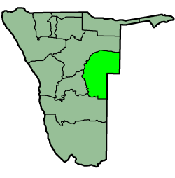
Otjiwarongo is a city of 28,000 inhabitants in the Otjozondjupa Region of Namibia. It is the district capital of the Otjiwarongo electoral constituency and also the capital of Otjozondjupa.
Trekkopje is a mountain in the Erongo Region of Namibia, c. 85 kilometres (53 mi) north-east of Swakopmund on the road to Usakos.
Daan Viljoen Game Reserve is a game reserve near Windhoek, Namibia. It is situated in the hill area of Khomas Hochland.
The park has many walking paths and allows tourists to travel around by themselves. The park is a good example of the wildlife of Namibia. It is named for Daniel Thomas du Plessis Viljoen (1892–1972), the South African administrator of South West Africa from 1953 to 1963.
Ongwediva is a town in the Oshana Region in the north of Namibia. It is the district capital of the Ongwediva electoral constituency. As of 2010 it had 27,000 inhabitants and covered 4,102 hectares of land. Ongwediva has seven churches, two private schools and 13 government-run schools. Most of the inhabitants speak Oshiwambo.
Gibeon is a meteorite that fell in prehistoric times in Namibia. It was named after the nearest town: Gibeon.
The Supreme Court of Namibia is the supreme court in all legal matters of the laws of Namibia. It is the court of last resort and the highest appellate court in the country. It is located in the centre of Namibia's capital city, Windhoek. A Supreme Court decision is supreme in that it can only be reversed by an Act of Parliament that contradicts it, or by another ruling of the Supreme Court itself.
Hochland Park is a residential suburb in Windhoek, the capital of Namibia. It is named after the German Khomas Hochland, the central-Namibian plateau area in which Windhoek is situated.
The Windhoek Industrial and Agricultural Show is an annual trade fair in Windhoek, the capital of Namibia. It combines an agricultural exhibition, several industrial and retail offerings, and a range of entertainment facilities. The Windhoek Show was first held in 1899 and is since 1966 conducted annually. Held during the first week of October, the Windhoek Show is the biggest industrial and agricultural exhibition in Namibia. It attracts close to 100,000 visitors per year.
St. Paul's College is a private school in Windhoek, the capital of Namibia.
Windhoek West Constituency is an electoral constituency in the Khomas Region of Namibia. It contains the affluent suburbs of Hochland Park, Pioneers Park, Academia - Windhoek, Cimbebasia, Rocky Crest, Windhoek North and Windhoek West.
Mudumu is a National Park in Caprivi Region in north-eastern Namibia. The Park was established in 1990. It covers an area of 737 square kilometres (285 sq mi). Botswana borders it to the west and is surrounded by communal area conservancies. The Kwando River forms the western border with Botswana. Various communal area conservancies and community forests surround Mudumu National Park.
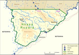
Nkasa Rupara National Park, also Nkasa Lupala National Park, formerly Mamili National Park, is a national park in Namibia. It is centered on the Nkasa and Rupara islands on the Kwando/Linyanti River in the south-western corner of East Caprivi. Botswana lies to the west, south and east, and Sangwali village to the north. It is Namibia's largest formally protected wetland area.
It is one of Namibia’s protected areas that benefits local communities surrounding parks. The unfenced park forms a trans-boundary link for wildlife migration between Angola, Botswana, Namibia and Zambia. Nkasa Rupara is part of the Kavango Zambezi Transfrontier Conservation Area.
Neudamm is a farm and settlement in the Khomas Region of central Namibia, situated on the B6 between Windhoek and Gobabis close to Windhoek's international airport. The entire area is a campus of the University of Namibia for agricultural education and experimental farming. Neudamm Railway Station connects the settlement to the railway network.