Hakahau

Last updated
Hakahau
Baie d'Hakahau (Ua Pou), vue du nord-ouest.jpg
Marquesas Islands location map.svg
Red pog.svg
Location within Marquesas Islands
Location of Hakahau
Hakahau
Coordinates: 9°21′40″S140°2′57″W / 9.36111°S 140.04917°W / -9.36111; -140.04917
Country France
Overseas collectivity French Polynesia
Subdivision Marquesas Islands
Commune Ua-Pou
Area
1
4.333 km2 (1.673 sq mi)
Population
 (2022) [1]
1,654
  Density380/km2 (990/sq mi)
Time zone UTC−10:00
1 French Land Register data, which excludes lakes, ponds, glaciers > 1 km2 (0.386 sq mi or 247 acres) and river estuaries.

Hakahau is the main village and port of the island of Ua Pou, in the Marquesas Islands, northeast of French Polynesia. It is the capital of the municipality. It is located at the bottom of a sheltered bay on the northeast side of the island, and has a sheltered dock by a jetty. The Aranui 3 stops at Hakahau. [2]

Contents

Geography

Climate

Hakahau has a tropical monsoon climate (Köppen climate classification Am). The average annual temperature in Hakahau is 25.5 °C (77.9 °F). The average annual rainfall is 1,345.5 mm (52.97 in) with May as the wettest month. The temperatures are highest on average in March, at around 26.2 °C (79.2 °F), and lowest in September, at around 25.0 °C (77.0 °F). The highest temperature ever recorded in Hakahau was 32.1 °C (89.8 °F) on 13 April 2007; the coldest temperature ever recorded was 16.2 °C (61.2 °F) on 28 August 1997.

Climate data for Hakahau (1991−2020 normals, extremes 1997−present)
MonthJanFebMarAprMayJunJulAugSepOctNovDecYear
Record high °C (°F)31.5
(88.7)
31.7
(89.1)
31.6
(88.9)
32.1
(89.8)
31.6
(88.9)
31.4
(88.5)
30.7
(87.3)
30.7
(87.3)
31.0
(87.8)
31.3
(88.3)
31.4
(88.5)
31.2
(88.2)
32.1
(89.8)
Mean daily maximum °C (°F)28.6
(83.5)
29.0
(84.2)
29.3
(84.7)
29.4
(84.9)
29.2
(84.6)
28.7
(83.7)
28.2
(82.8)
28.0
(82.4)
28.1
(82.6)
28.4
(83.1)
28.4
(83.1)
28.7
(83.7)
28.7
(83.7)
Daily mean °C (°F)25.5
(77.9)
25.9
(78.6)
26.2
(79.2)
26.1
(79.0)
26.0
(78.8)
25.6
(78.1)
25.1
(77.2)
25.0
(77.0)
25.0
(77.0)
25.2
(77.4)
25.3
(77.5)
25.5
(77.9)
25.5
(77.9)
Mean daily minimum °C (°F)22.4
(72.3)
22.9
(73.2)
23.0
(73.4)
22.9
(73.2)
22.8
(73.0)
22.4
(72.3)
22.0
(71.6)
22.0
(71.6)
21.9
(71.4)
22.0
(71.6)
22.2
(72.0)
22.4
(72.3)
22.4
(72.3)
Record low °C (°F)18.0
(64.4)
19.1
(66.4)
18.1
(64.6)
17.1
(62.8)
17.4
(63.3)
18.0
(64.4)
17.1
(62.8)
16.2
(61.2)
16.4
(61.5)
17.1
(62.8)
17.7
(63.9)
18.4
(65.1)
16.2
(61.2)
Average precipitation mm (inches)152.5
(6.00)
117.8
(4.64)
186.5
(7.34)
123.2
(4.85)
114.2
(4.50)
108.1
(4.26)
128.2
(5.05)
77.7
(3.06)
64.0
(2.52)
78.3
(3.08)
117.4
(4.62)
77.6
(3.06)
1,345.5
(52.97)
Average precipitation days (≥ 1.0 mm)11.511.714.012.012.611.512.610.19.411.011.79.0137.0
Source: Météo-France [3]

Related Research Articles

<span class="mw-page-title-main">Tubuai</span> Island in French Polynesia

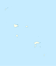
Tubuai, Tubuaʻi or Tupuaʻi is the main island of the Austral Island group, located 640 km (400 mi) south of Tahiti. In addition to Tubuai, the group of islands include Rimatara, Rurutu, Raivavae, Rapa and the uninhabited Îles Maria. They are part of the Austral Islands in the far southwest of French Polynesia in the south Pacific Ocean. Tubuai island sustains a population of 2,185 people on 45 km2 of land. Due to its southerly position, Tubuai has notably cooler weather than Tahiti.

<span class="mw-page-title-main">Saint-Louis, Réunion</span> Commune in Réunion, France

Saint-Louis is the fifth-largest commune in the French overseas department of Réunion. It is located on the southwest part of the island of Réunion, adjacent to Saint-Pierre.

<span class="mw-page-title-main">Saint-Paul, Réunion</span> Subprefecture and commune in Réunion, France

Saint-Paul is the second-largest commune in the French overseas department of Réunion. It is located on the extreme west side of the island of Réunion.

<span class="mw-page-title-main">Le Mont-Dore (New Caledonia)</span> Commune in New Caledonia, France

Le Mont-Dore is a commune in the suburbs of Nouméa in the South Province of New Caledonia, an overseas territory of France in the Pacific Ocean.

<span class="mw-page-title-main">Punaauia</span> Commune in French Polynesia, France

Puna'auia is a commune in the suburbs of Papeʻete in French Polynesia, an overseas territory of France in the Pacific Ocean. Puna'auia is located on the island of Tahiti, in the administrative subdivision of the Windward Islands, themselves part of the Society Islands. In the late 1890s, the French painter Paul Gauguin lived in Puna'auia. Here he painted his masterpiece Where Do We Come From? What Are We? Where Are We Going?. The commune borders Faʻaʻā on the north and Pāʻea on the south.

<span class="mw-page-title-main">Sainte-Marie, Martinique</span> Commune in Martinique, France

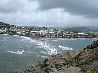
Sainte-Marie is a town and the fifth-largest commune in the French overseas department of Martinique. It is located on the northeast side of the island of Martinique.

<span class="mw-page-title-main">Boulouparis</span> Commune in New Caledonia, France

Boulouparis is a commune in the South Province of New Caledonia, an overseas territory of France in the Pacific Ocean.

<span class="mw-page-title-main">Paea</span> Commune in French Polynesia, France

Pāʻea is a commune in the suburbs of Papeʻete in French Polynesia, an overseas territory of France in the southern Pacific Ocean. Pāʻea is located on the island of Tahiti, in the administrative subdivision of the Windward Islands, themselves part of the Society Islands. At the 2022 census it had a population of 12,756.

<span class="mw-page-title-main">Papara</span> Commune in French Polynesia, France

Paparā is a commune of French Polynesia, an overseas territory of France in the Pacific Ocean. Paparā is located on the island of Tahiti, in the administrative subdivision of the Windward Islands, themselves part of the Society Islands. At the 2022 census it had a population of 11,743.

Afaahiti is a village and associated commune in Tahiti. It is located on Tahiti Iti close to the Taravao isthmus, which connects Tahiti Nui to Tahiti Iti. The area is rural with many small villages. The official languages are French and Tahitian. The currency is the Pacific franc (XPF). Population as of 2022 was 6,829. Tahiti's west coast freeway runs nearby the commune. The Faaa International Airport is another way to transport in Afaahiti.

<span class="mw-page-title-main">La Plaine-des-Palmistes</span> Commune in Réunion, France

La Plaine-des-Palmistes is a commune in the French overseas department of Réunion.

<span class="mw-page-title-main">Le Morne-Rouge</span> Commune in Martinique, France

Le Morne-Rouge is a commune and town in the French overseas department and island of Martinique.

<span class="mw-page-title-main">Takaroa</span> Atoll in French Polynesia

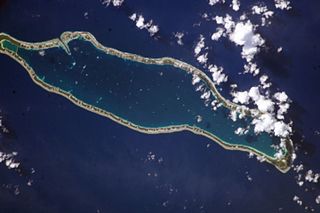
Takaroa, Taka-roa or Takapua, is an atoll in the Tuamotu group in French Polynesia. It has a length of 27.4 kilometres and a width of 7 km (4 mi); its land area is 20 square kilometres.

<span class="mw-page-title-main">Macouba</span> Commune in Martinique, France

Macouba is a village and commune in the French overseas department of Martinique.

<span class="mw-page-title-main">Fonds-Saint-Denis</span> Commune in Martinique, France

Fonds-Saint-Denis is a village and commune in the French overseas department and region, and island, of Martinique. It is the smallest commune of the island.

<span class="mw-page-title-main">Sisco, Haute-Corse</span> Commune in Corsica, France

Sisco is a commune in the Haute-Corse department of France on the island of Corsica. It takes its name from the Ruisseau de Sisco, which flows through the commune and enters the Tyrrhenian Sea in the village of Sisco.

<span class="mw-page-title-main">Pao Pao</span> Associated commune on the island of Moʻorea, in French Polynesia

Pao Pao is an associated commune on the island of Moʻorea, in French Polynesia. It is part of the commune Moʻorea-Maiʻao. According to the census in 2022, it had a population of 4,895. It is the largest village in Moʻorea.

<span class="mw-page-title-main">Bora-Bora (commune)</span> Place in French Polynesia, France

Bora-Bora is a commune of French Polynesia, an overseas territory of France in the Pacific Ocean. The commune is in the administrative subdivision of the Leeward Islands. Its population was 10,758 at the 2022 census.

<span class="mw-page-title-main">Opoa</span> Associated commune of Taputapuatea in French Polynesia, France

Opoa is a village on the island of Raiatea, in French Polynesia. According to the 2022 census, it had a population of 1,205.

<span class="mw-page-title-main">Papetoai</span> Associated commune of Moʻorea-Maiʻao in French Polynesia, France

Papetoai is an associated commune on the island of Mo'orea, in French Polynesia. It is part of the commune Moorea-Maiao. According to the 2022 census, it had a population of 2,214.

References

  1. "Les résultats du recensement de la population 2022 de Polynésie française" [Results of the 2022 population census of French Polynesia](PDF) (in French). Institut de la statistique de la Polynésie française. January 2023.
  2. Wheeler, Tony; Carillet, Jean-Bernard (1997). Tahiti & French Polynesia . Lonely Planet. p.  320. ISBN   978-0-86442-287-3.
  3. "Fiche Climatologique Statistiques 1991-2020 et records" (PDF). Météo-France . Retrieved August 25, 2022.