Pangani District Council is one of eleven administrative districts of Tanga Region in Tanzania. The District covers an area of 1,756 km2 (678 sq mi). It is bordered to the north by Muheza District, to the east by Zanzibar Channel, to the south by the Chalinze District of Pwani Region, and to the west by the Handeni District. The district is comparable in size to the land area of Guadeloupe. The district seat (capital) and largest settlement in Pangani district is the town of Pangani. The district is named after the historic Pangani River. As of the 2022 census, the population was Pangani district was 75,642, making it the least populous district in Tanga Region.

The Usambara Mountains of northeastern Tanzania in tropical East Africa, comprise the easternmost ranges of the Eastern Arc Mountains. The ranges of approximately 90 kilometres (56 mi) long and about half that wide, are situated in the Lushoto District of the Tanga Region. They were formed nearly two million years ago by faulting and uplifting, and are composed of Precambrian metamorphic rocks. They are split into two sub-ranges; the West Usambaras being higher than the East Usambaras, which are nearer the coast and receive more rainfall.
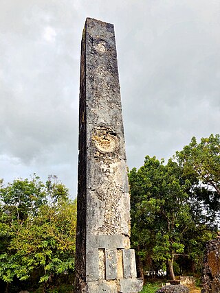
The Tongoni Ruins are a 15th century Swahili ruins of a mosque and forty tombs located in Tongoni ward in Tanga District inside Tanga Region of Tanzania. The largest and possibly most significant Swahili site in Tanzania is Tongoni, which is located 25 km north of the Pangani River. Overlooking Mtangata Bay, about forty standing tombs and a Friday mosque of the "northern" style occupy a third of a hectare. People from the area continue to worship there spiritually. They bury their departed family members to the south of the historic tombs. The area was a different place four to five centuries ago. Contrary to its almost unnoticed presence today, it was a prosperous and a respected Swahili trading centre during the 15th century. Most of the ruins are still not yet been uncovered. The site is a registered National Historic Site.

Nyumba ya Mungu Dam is a Tanzanian, hydroelectric dam located in and operated in Mwanga District, Kilimanjaro Region. It was built in the late 1960s and is Kilimanjaro region's largest artificial water body. Nyumba ya Mungu Reservoir. The reservoir is shared with Moshi District of Kilimanjaro Region and Simanjiro District of Manyara Region. Nyumba ya Mungu means 'House of God'. Its installed capacity is 8 megawatts (11,000 hp).

Pangani Falls Dam is a dam in Tanzania, which is part of the Pangani Hydro Systems. The dam is located at Koani in the Muheza District of the Tanga Region, about 8 km (5.0 mi) south of another power station at Hale. The Pangani falls power station has two turbines and has an installed capacity of 68 megawatts (91,000 hp).
Hale Dam is a hydroelectric dam in Tanzania, located in the town of Hale in Mnyuzi ward of Korogwe District of Tanga Region. Its installed capacity is 21 megawatts (28,000 hp). Thousands of people were displaced to build the dam.
The Zigua or in some sources Zigula are a Bantu ethnic and linguistic people hailing from far northern Pwani Region and western southern Tanga Region in Tanzania. In Tanga Region they are the majority in Handeni District, northern Kilindi District and also are a historically significant population south of the Pangani River in Pangani District. They speak the Zigula language. In 1993, the Zigua population was estimated to number 355,000 people, today they number 631,000 people.

The Pangani longclaw is a species of bird in the family Motacillidae, which includes the pipits and wagtails. It is found in Tanzania, Kenya and Somalia. The bird's natural habitats are dry savanna and subtropical or tropical dry lowland grassland.

Ctenochromis pectoralis, the Pangani haplo, is a species of fish in the family Cichlidae. It was originally characterized in the Pangani River of Tanzania, and may also be present in Kenya. It is listed as extinct by IUCN as a result of a 1996 evaluation, but this appears to be incorrect. A more recent IUCN publication stated that this species is not endangered in any way.

Oreochromis jipe, the Jipe tilapia, is a critically endangered species of cichlid fish native to Kenya and Tanzania, where it is restricted to Lake Jipe and the Pangani River. The population in the Pangani River shows some morphological differences compared to the population in Lake Jipe, and it is sometimes recognized as a separate species, the Pangani tilapia. Whether regarded as one or two species, the Jipe–Pangani tilapia forms a species flock with the threatened Lake Chala tilapia from the same general region of Kenya and Tanzania.
Ligunga is a town in southern Tanzania near the border with Mozambique.

Chillianwala is a village and union council of Mandi Bahauddin District in the Punjab province of Pakistan. It is located at 32°39'0N 73°36'0E at an altitude of 218 metres and lies to the north-east of the district capital Mandi Bahauddin.

Tanzania Ports Authority (TPA) is a parastatal public corporation acting under the aegis of the Ministry of Infrastructure Development, that has the responsibility "to manage and operate" the ocean ports and lake ports of the country of Tanzania. The Tanzania Ports Authority headquarters are located in Mchafukoge ward of Ilala District in Dar es Salaam Region. It is a member of the Port Management Association of Eastern and Southern Africa.
Lela is a small town in western Kenya near Lake Victoria. Elevation 1454m.
Sandama is a small town in south central Malawi. To the immediate east is a border with Mozambique.
Samburu is a village located in Kwale County, Kenya.

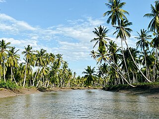
The Pangani River, is a major river of northeastern Tanzania. It has two main sources: the Ruvu, which rises as Lumi at Kilimanjaro, passes through Lake Jipe, and empties into the Nyumba ya Mungu Reservoir, and the Kikuletwa River, coming from the west and mainly fed by rivers of Mount Meru in Arusha Region, which also enters into the Nyumba ya Mungu Reservoir in Kilimanjaro Region. Just after leaving the reservoir the stream becomes the main Pangani, which empties into the Indian Ocean in Tanga Region at the Tangan port town of Pangani.
Msangazi River is a river of Tanzania. It is part of the Pangani River basin.

Zanzibar Electricity Corporation is a state owned utility firm that provides transmission and distribution service of electricity in the Zanzibar Archipelago. The firm was incorporated in 2006 as the successor of the State Fuel and Power Corporation and is wholly owned by the Revolutionary Government of Zanzibar.

Pangani Mashariki is an administrative ward in Pangani District of Tanga Region in Tanzania. The ward cover the eastern part of Pangani Town. The ward is also the seat of the district capital, with the district council building located in the north of the ward. Pangani mashariki is one of 13 wards in Pangani District as of 2012. The ward covers an area of 13 km2 (5.0 sq mi), and has an average elevation of 37 m (121 ft).